Method for measuring height by fusing unmanned helicopter barometric altimeter and GPS (global positioning system)

A barometric altimeter and unmanned helicopter technology, which is applied in the field of unmanned aerial vehicles and aerospace, can solve the problems of limited application range, achieve the effects of light weight, improved reliability and accuracy, and improved safety

Inactive Publication Date: 2011-04-20
TSINGHUA UNIV
View PDF3 Cites 42 Cited by
  • Summary
  • Abstract
  • Description
  • Claims
  • Application Information

AI Technical Summary

Problems solved by technology

Due to the reasons mentioned above, the above two measurement method...

Method used


Image

  • Method for measuring height by fusing unmanned helicopter barometric altimeter and GPS (global positioning system)
  • Method for measuring height by fusing unmanned helicopter barometric altimeter and GPS (global positioning system)
  • Method for measuring height by fusing unmanned helicopter barometric altimeter and GPS (global positioning system)

Examples


Embodiment Construction

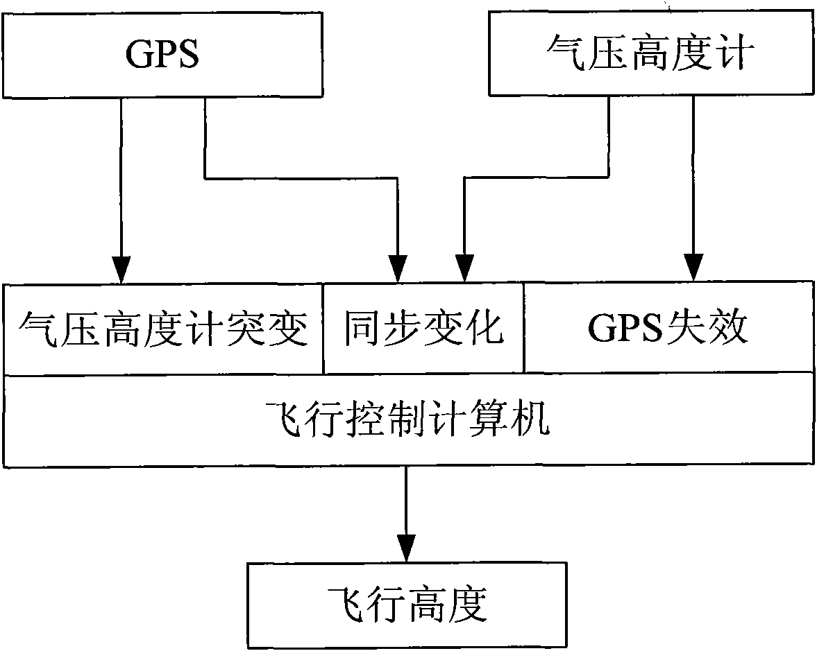
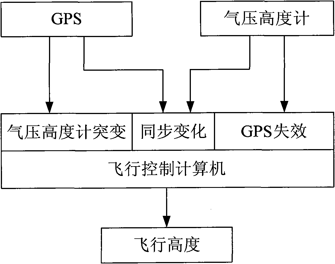
[0015] The unmanned helicopter barometric altimeter and GPS fusion altimeter method is composed of barometric altimeter, GPS global positioning system and flight control computer.

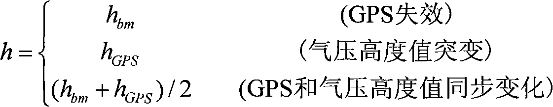
[0016] According to the following different situations, the flight control computer fuses the altitude measurement value of the barometric altimeter and GPS as the flight altitude h of the helicopter.

[0017] Case 1, when the unmanned helicopter takes off in buildings and bushes, the GPS will fail and the height h cannot be measured GPS . Therefore, when the GPS fails, the barometric altitude h is used bm As the flight height value h of the helicopter.

[0018] In the second case, when the weather changes suddenly or gusts of wind blow over the unmanned helicopter, it will cause a sudden change in air pressure. At this time, the measured value h of the barometric altimeter bm There will also be a sudden change, but in fact the flying height h of the helicopter may not change. Therefore, when ...


PUM


Abstract

The invention discloses a method for measuring height by fusing an unmanned helicopter barometric altimeter and a GPS (global positioning system), belonging to the technical field of unmanned helicopter flight control. The method is characterized in that a barometric altimeter, the GPS and a flight control computer are utilized, wherein, the barometric altimeter and the GPS form a redundancy height measuring system; the effective flight height value of the unmanned helicopter is obtained after the height measuring value of the barometric altimeter and the height measuring value of the GPS are fused by the flight control computer, when the GPS is in failure, the height value of the barometric altimeter is adopted; when the height value of the air pressure changes suddenly, and the height value of the GPS does not change, the height value of the GPS is adopted; and when the height value of the air pressure and the height value of the GPS change synchronously, the mean value of the height values of the GPS and the air pressure is taken as the flight height value. By fusing the height measuring value of the barometric altimeter and the height measuring value of the GPS, the method provided by the invention has the advantages that the reliability and accuracy of the height measurement are improved, and the conditions that the barometric altimeter is easily influenced by gust when being used singly and the GPS is easily influenced by the surrounding condition when being used singly are avoided.

Description

technical field [0001] The invention is a method for measuring the flying height of the unmanned helicopter, which can accurately and reliably measure the flying height of the unmanned helicopter by fusing the measured values ​​of the barometric altimeter and GPS. Mainly used in aerospace, UAV and other technical fields. Background technique [0002] There are usually five methods for measuring the flight height of unmanned helicopters, namely using barometric altimeter, GPS, laser range finder, ultrasonic range finder and radar range finder to measure the flight height. [0003] The barometric altimeter has a large measurement range, but it is susceptible to inaccurate altitude measurement due to weather changes and gusts; [0004] The GPS height measurement range is large, but it is easily blocked by surrounding buildings and trees and fails. Therefore, when the unmanned helicopter takes off in buildings and bushes, it will be unable to measure the flight altitude due to...

Claims


Application Information

Patent Timeline
IPC IPC(8): G01C5/00G01C5/06G01S19/42
Inventor 王冠林朱纪洪
Owner TSINGHUA UNIV
Why Eureka
Try Eureka