Navigation method, electronic map system and navigation device

A navigation method and electronic map technology, applied to road network navigators and other directions, can solve problems such as unrealized guiding users to information point A

Active Publication Date: 2011-05-04
NAVINFO
View PDF5 Cites 8 Cited by
  • Summary
  • Abstract
  • Description
  • Claims
  • Application Information

AI Technical Summary

Problems solved by technology

[0010] like figure 2 As shown, the user needs to reach information point A (that is, information point A as the destination), the situation is as follows: road L1 and road L2 interchange, information point A can only reach road L2 actually, but if the existing technology is used at this time, then The navigation system calculates the distance between information point A and the surrounding roads (road L1 and road L2). The distance between information point A and road L1 is shorter than

Method used


Image

  • Navigation method, electronic map system and navigation device
  • Navigation method, electronic map system and navigation device
  • Navigation method, electronic map system and navigation device

Examples


Embodiment Construction

[0064] In order to make the technical problems, technical solutions and advantages to be solved by the embodiments of the present invention clearer, the following will describe in detail with reference to the drawings and specific embodiments.

[0065] The embodiments of the present invention aim at the problem that the existing navigation technology cannot accurately guide the user from the current point to the destination, and provide a navigation method, an electronic map system and a navigation system that can accurately guide the user from the current point to the destination. device.

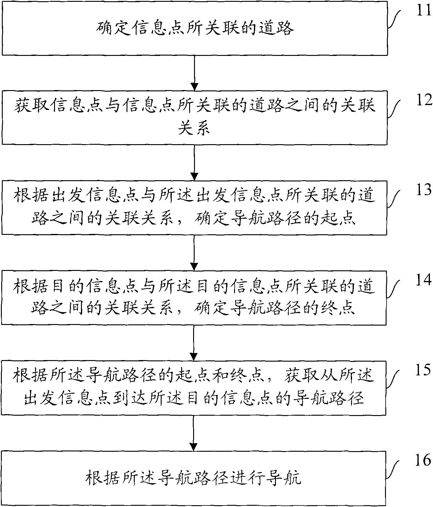
[0066] Such as image 3 As shown, the navigation method of the present invention includes:

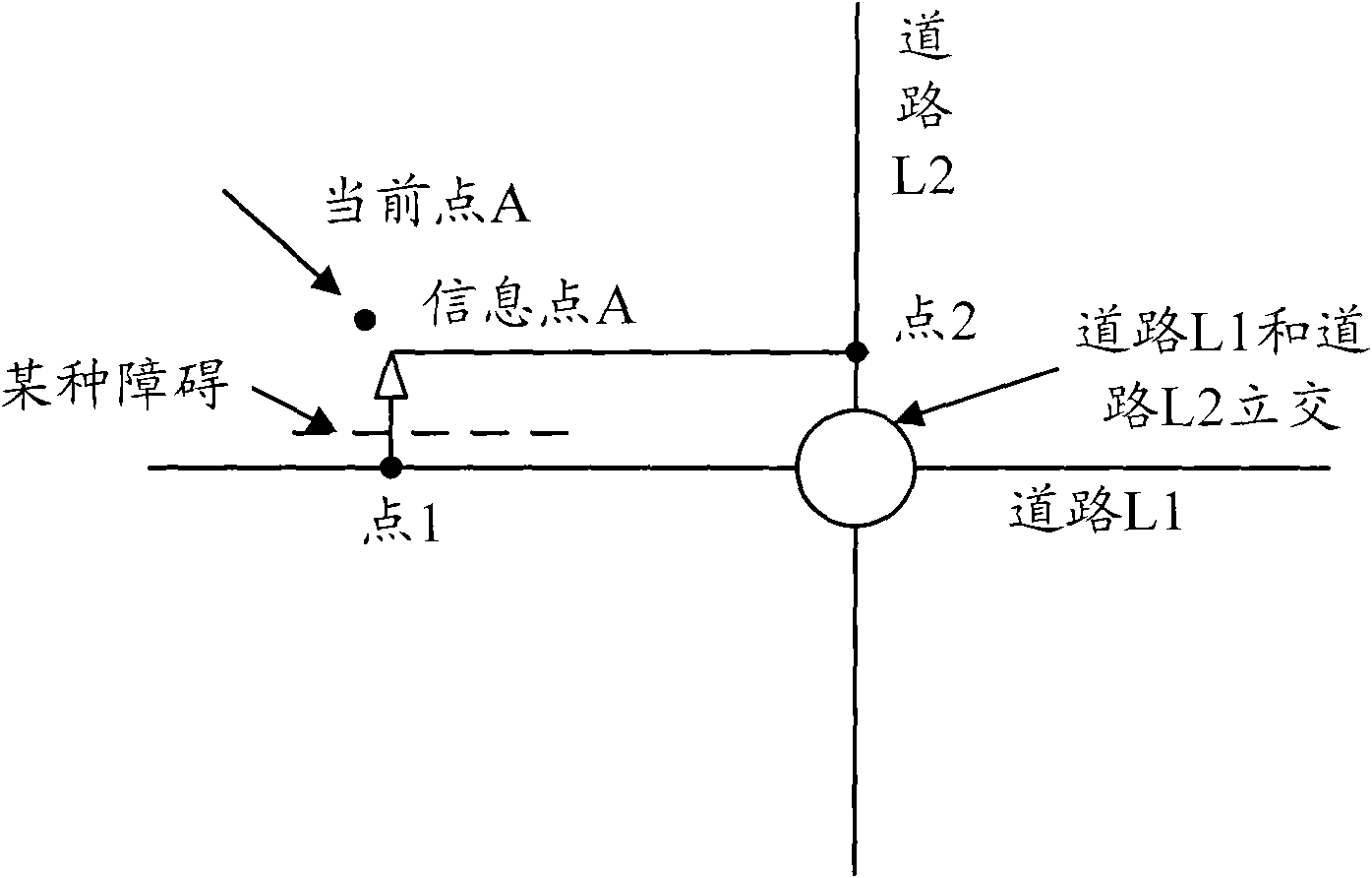
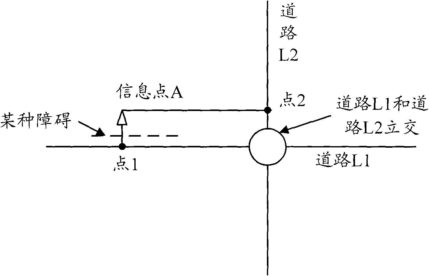
[0067] Step 11, determine the road associated with the information point, the road associated with the information point refers to: the road closest to the information point and passing through the information point; the information point here is the information defined in the electronic map field...


PUM


Abstract

The invention provides a navigation method, an electronic map system and a navigation device. The method comprises the steps: confirming a road which is associated with an information point; obtaining an associating relationship between the information point and the road which is associated with the information point; confirming a starting point of a navigation path according to an associating relationship between a starting information point and a road which is associated with the starting information point; confirming the end point of the navigation path according to an associating relationship between a destination information point and a road which is associated with the destination information point; obtaining a navigation path from the starting information point to the destination information point according to the starting point and the end point of the navigation path; and navigating according to the navigation path. The scheme adopted by the invention can accurately confirm the starting point of the navigation, and the most important is that the navigation arriving at the destination accurately can be realized.

Description

technical field [0001] The invention relates to the technical field of navigation based on an electronic map, in particular to a navigation method, an electronic map system and a navigation device capable of accurately determining the starting point of navigation and, more importantly, accurately reaching the destination. Background technique [0002] In the existing navigation technology, there must be a road network in the navigation electronic map to realize the planning of the navigation route, thereby realizing the navigation. [0003] To guide the user from the current point to the destination, the navigation system first needs to determine a certain point on the road that the current point can reach, and a certain point on the road that the destination can reach, and then use the certain point on the road that the current point can reach as the The starting point of the navigation path is a certain point on the road that can be reached by the destination as the end po...

Claims


Application Information

Patent Timeline
IPC IPC(8): G01C21/34
Inventor 胡发根
Owner NAVINFO
Why Eureka
Try Eureka