Processing system of web map and geographical space analysis as well as device and method thereof

A geospatial and web map technology, applied in the direction of electrical digital data processing, special data processing applications, instruments, etc., can solve the problem of not providing geospatial analysis and so on

Inactive Publication Date: 2011-06-29
FENG CHIA UNIVERSITY
View PDF0 Cites 4 Cited by
  • Summary
  • Abstract
  • Description
  • Claims
  • Application Information

AI Technical Summary

Problems solved by technology

Relatively speaking, the Google Maps-oriented system map platform does not provide geospatial analysis functions, unless a specific program is developed to achieve similar functions, but it is also limited to vector data of simple "points, lines, and planes" , perform nested actions, such as simple position positioning, etc.

Method used


Image

  • Processing system of web map and geographical space analysis as well as device and method thereof
  • Processing system of web map and geographical space analysis as well as device and method thereof
  • Processing system of web map and geographical space analysis as well as device and method thereof

Examples


Embodiment Construction

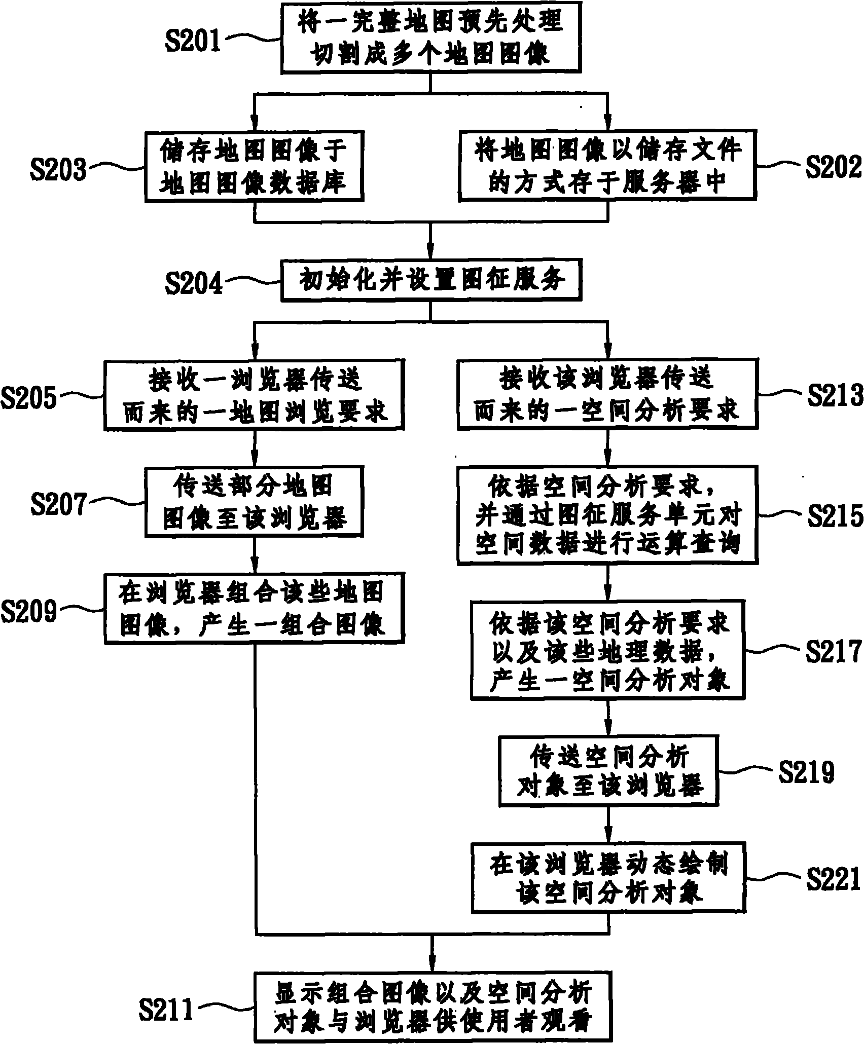
[0028] The present invention speeds up the browsing speed by pre-segmenting and processing the map and storing it in the server, cooperates with the self-developed feature service (Feature Service) to perform geospatial analysis (Geospatial Analysis) according to user needs, and uses the browser to analyze the results Dynamically draw and display for users to watch.

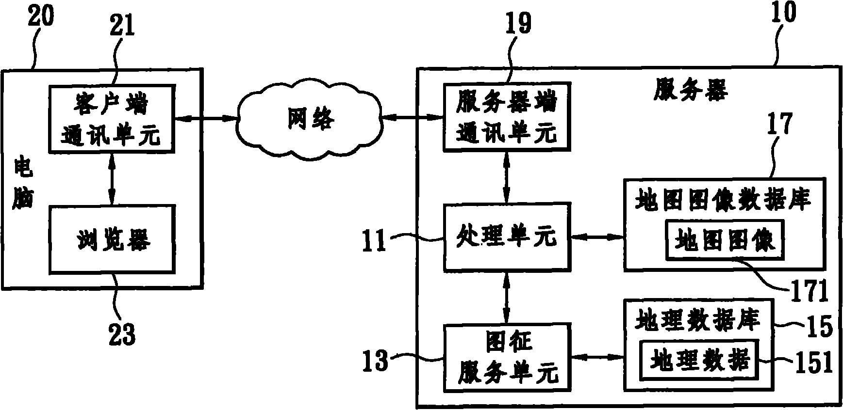
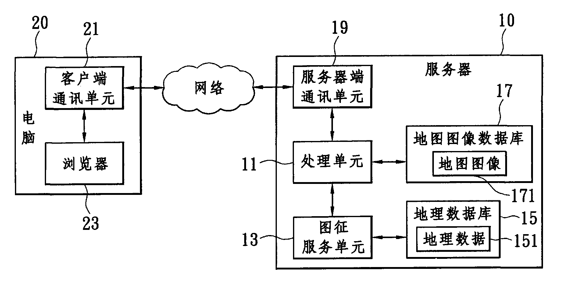
[0029] see figure 1 , is a block diagram of an embodiment of a processing system for web map and geospatial analysis, including a server 10 and a computer 20 connected to the server 10 through a network. Server 10 provides web map browsing and geospatial analysis services, that is, a web map and geospatial analysis device, including a processing unit 11, a graphic feature service unit 13, a geographic database 15, a map image database 17, and a Server-side communication unit 19. Among them, the processing unit 11 is the computing processing center of the server 10, and has an AJAX processing module (figure omit...


PUM


Abstract

The invention discloses a processing system of web map and geographical space analysis as well as a device and a method thereof. The system comprises a server for providing web map browsing and geographical space analysis and a computer connected with the server; the serve comprises a processing unit, an emblem service unit, a geographical database, a map image database and a server end communication unit, and the computer comprises a client communication unit and a browser. Map browsing speed is quickened and complete geographical space analysis is provided by adopting a self-developed emblem service, executing the geographical space analysis with brief mechanism, and utilizing the preset map image combined with the region browsed by a user to serve as a geographical image transmitting method.

Description

technical field [0001] The invention relates to a method for processing maps on a webpage, in particular to a processing system for webpage maps and geospatial analysis and its device and method. Background technique [0002] The system maps of the known web geographic information system (Web GIS) are mainly divided into two types, one is oriented by the web map service standard (Web Map Service, WMS) formulated by the Open Geospatial Consortium (OGC) The system map platform, the other is the system map platform oriented by WMTS (Web Map Tiled Service), generally the more well-known one is Google Maps. [0003] Among them, the WMS-oriented system map platform provides the function of geospatial analysis (Geospatial Analysis), but the browsing speed is too slow. The analysis is generated on the server in real time, and then sent to the user for browsing, so the speed is relatively slow. [0004] The Google Maps-oriented system map platform generates a complete map in advanc...

Claims


Application Information

Patent Timeline
Patent Type & Authority Applications(China)
IPC IPC(8): G06F17/30
Inventor 林育生李勇庆萧欣永陈美心周天颖
Owner FENG CHIA UNIVERSITY
Why Eureka
Try Eureka