Multi-layer hybrid indexing method

A multi-layer, index-based technology, applied in the field of map drawing, can solve problems such as the increase in the amount of map information, and achieve the effect of improving browsing speed and overall drawing efficiency

Inactive Publication Date: 2017-05-31
HUBEI KINGTOPWARE INFORMATION TECH
View PDF4 Cites 7 Cited by
  • Summary
  • Abstract
  • Description
  • Claims
  • Application Information

AI Technical Summary

Problems solved by technology

[0009] There are more and more layers, resulting in a larger amount of information drawn on the entire map

Method used


Image

  • Multi-layer hybrid indexing method
  • Multi-layer hybrid indexing method
  • Multi-layer hybrid indexing method

Examples


Embodiment Construction

[0048] The present invention will be further described below in conjunction with the accompanying drawings and embodiments.

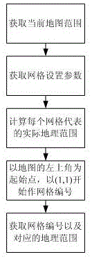
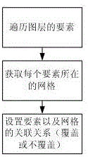
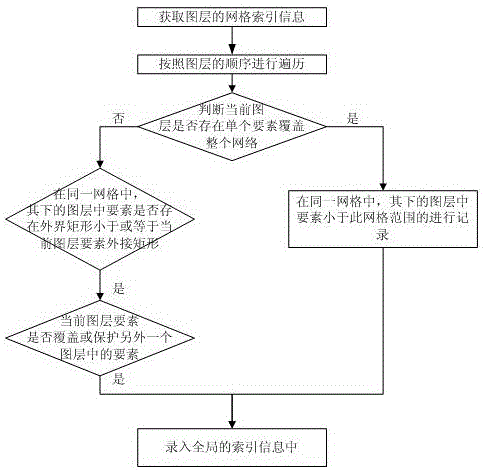
[0049] Such as Figure 1 to Figure 3 As shown, a multi-layer hybrid indexing technology to improve the overall drawing efficiency of the map, including the following steps:

[0050] Step 1. Select the indexing method. There are many existing spatial indexing methods. Here, it is recommended to use the grid indexing method as the overall indexing method;

[0051] Step 2, get the information of the current map

[0052] Step 201, obtaining all layers of the map;

[0053] Step 202, obtaining the layers of the map and numbering the layers, numbering from top to bottom, numbering starts from 0, the upper layer has a smaller number, and the lower layer has a larger number;

[0054] Step 203, obtaining the total amount of data of each layer;

[0055] Step 3, the rules for constructing the index, the grid size and distribution of the grid index for construct...


PUM


Abstract

The invention discloses a multi-layer hybrid indexing method. The method comprises the steps of selecting an indexing mode; acquiring current map information; constructing indexing rules as well as grid size and distribution for grid indexing; constructing an index according to the grid size and distribution for each layer; constructing an index of the whole map according to the layer sequence of the whole map; and setting a drawing effect according to a global indexing result. According to the method, a multi-layer hybrid indexing technology is proposed, the multi-layer index is constructed for the map under the condition that layer distribution is fixed in the same map, and the overall drawing efficiency of the map is improved.

Description

technical field [0001] The invention belongs to the technical field of map drawing, and in particular relates to a multi-layer hybrid indexing method. Background technique [0002] Spatial index refers to a data structure arranged in a certain order according to the position and shape of spatial objects or a certain spatial relationship between spatial objects, which contains the general information of spatial objects, such as object identification, circumscribing rectangle and pointing space A pointer to the object entity. [0003] Spatial data query, namely spatial index, is a description of the location information of data stored on the medium and is used to improve the efficiency of data acquisition by the system. It is also called Spatial Access Method (SAM). It refers to a data structure arranged in a certain order according to the position and shape of the spatial object or a certain spatial relationship between the spatial objects, which contains the general informa...

Claims


Application Information

Patent Timeline
Patent Type & Authority Applications(China)
IPC IPC(8): G06T11/60G06F17/30
Inventor 李三玉郑波邹晶范翼何亮陈俊伟周争义郑良
Owner HUBEI KINGTOPWARE INFORMATION TECH
Why Eureka
Try Eureka