Space position sharing method based on electronic map, device and system

An electronic map and spatial location technology, which is applied in the directions of maps/plans/charts, electronic digital data processing, special data processing applications, etc., can solve the problems of cumbersome operation and inability to obtain the position changes of companions, and achieve continuous location sharing and improve The effect of user experience

Inactive Publication Date: 2011-08-10
BEIJING LINGTU SOFTWARE TECH CO LTD
View PDF3 Cites 21 Cited by
  • Summary
  • Abstract
  • Description
  • Claims
  • Application Information

AI Technical Summary

Problems solved by technology

[0004] The technical problem to be solved by the present invention is to provide a spatial location sharing method based on an electronic map,

Method used


Image

  • Space position sharing method based on electronic map, device and system
  • Space position sharing method based on electronic map, device and system
  • Space position sharing method based on electronic map, device and system

Examples


Embodiment Construction

[0026] In order to make the above objectives, features and advantages of the present invention more obvious and understandable, the present invention will be further described in detail below with reference to the accompanying drawings and specific embodiments.

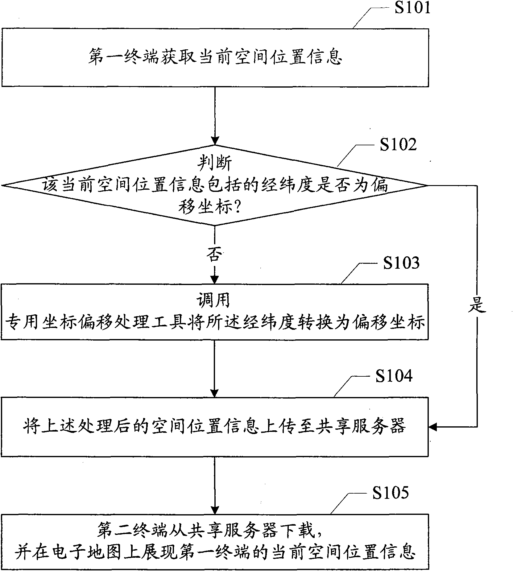
[0027] Reference figure 1 , Shows the flow of the first embodiment of the method for sharing a spatial location based on an electronic map of the present invention. The system includes a sharing server and at least two terminals. The method includes the following steps repeatedly executed at a preset time interval:

[0028] Step S101: the first terminal obtains current spatial location information;

[0029] The way the first terminal obtains the user’s spatial location information can be obtained by calling the GPS positioning module, and the obtained spatial location information includes latitude, longitude and direction angle; the spatial location information can also be obtained by the user tapping his own location on the ...


PUM


Abstract

The invention provides a space position sharing method based on an electronic map, a device and a system. The method comprises the following steps which are carried out repeatedly according to a pre-set time interval: using a first terminal to obtain current space positional information; judging whether longitudes and latitudes included in the current space positional information are offset coordinates, if not, calling a special coordinate offset processing tool to convert the longitudes and latitudes to the offset coordinates; uploading the processed current space positional information to a sharing server; and downloading a second terminal from the sharing server and displaying the current space positional information of the first terminal on the electronic map. In the method, the current position situation is obtained according to the pre-set time interval and is uploaded to a server to be downloaded and displayed by a sharing user after the corresponding offset processing is carried out on the current position situation as required, so as to realize continuous position sharing and lead a companion to dynamically know the variation condition of the position.

Description

Technical field [0001] The present invention relates to the technical field of geographic information processing, and in particular to a method, device and system for spatial location sharing based on electronic maps. Background technique [0002] Electronic maps are currently commonly used tools in public travel and life, and can be used to identify geographic locations. In practical applications, users will not only care about their location, but sometimes also care about the location of their peers and their location changes. [0003] However, in section 6.13 of the national mandatory standard GB20263-2006 "Basic Requirements for the Safe Processing of Electronic Navigational Maps", "spatial location coordinate values. Except for the officially announced spatial location coordinate values ​​of the country" as content that cannot be expressed. From the existing electronic map, the coordinate information of the spatial location cannot be directly obtained. In order to share the s...

Claims


Application Information

Patent Timeline
IPC IPC(8): G06F17/30G09B29/00
Inventor 龚晓岚丁胜昔英正明
Owner BEIJING LINGTU SOFTWARE TECH CO LTD
Why Eureka
Try Eureka