Underwater vehicle path planning method based on ocean current historical statistic information

A technology of historical statistics and path planning, applied in the direction of navigation calculation tools, etc.

Active Publication Date: 2011-09-07
哈尔滨哈船导航技术有限公司
View PDF5 Cites 49 Cited by
  • Summary
  • Abstract
  • Description
  • Claims
  • Application Information

AI Technical Summary

Problems solved by technology

[0004] The purpose of the present invention is to solve the defect of considering less ocean current factors in traditional path planning, and proposes a method for underwater submersible path planning based on historical statistical information of ocean currents

Method used


Image

  • Underwater vehicle path planning method based on ocean current historical statistic information
  • Underwater vehicle path planning method based on ocean current historical statistic information
  • Underwater vehicle path planning method based on ocean current historical statistic information

Examples


Embodiment Construction

[0017] The present invention will be further described in detail with reference to the accompanying drawings and embodiments.

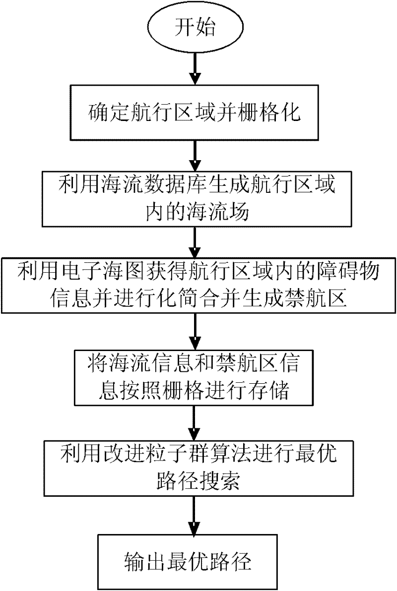
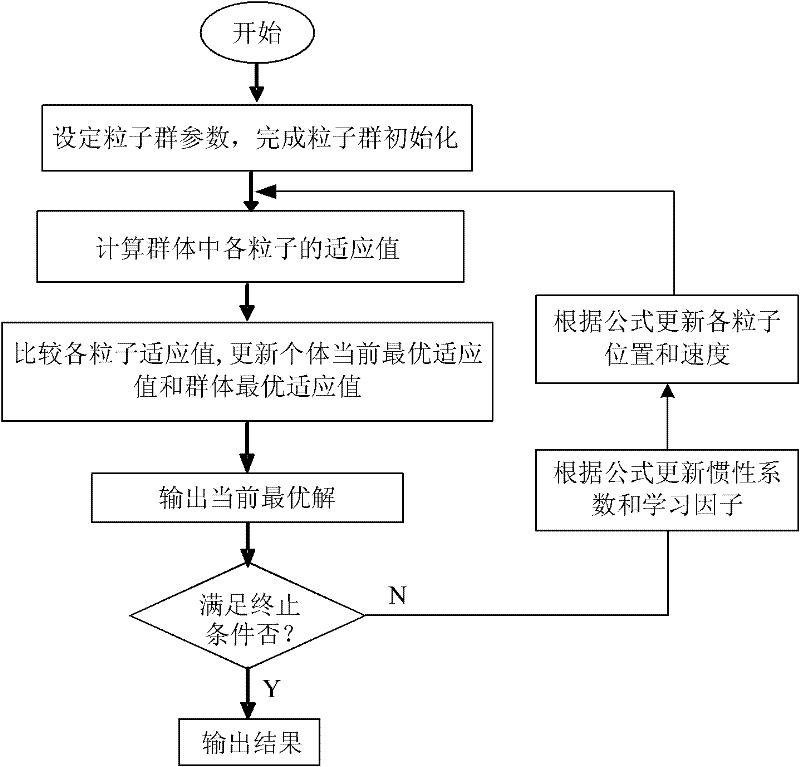
[0018] The present invention is a path planning method for underwater submersibles based on historical statistical information of ocean currents, which includes key contents such as environment modeling, ocean current field generation, path evaluation function design, and improved particle swarm algorithm design. The specific process is as follows: figure 1 shown, including the following:

[0019] Step 1. Determine the navigation area and rasterize the navigation area.

[0020] The navigation area is a rectangular area whose diagonal is the line connecting the starting point and the ending point of the route. Along the longitude and latitude directions, the division is performed at equal intervals in units of 10' to generate a grid area with a size of 10'X10'.

[0021] Step 2. Use the ocean current history statistics database to generate the ocean c...


PUM


Abstract

The invention discloses an underwater vehicle path planning method based on ocean current historical statistic information, comprising the following steps of: determining a sailing region, rasterizing the sailing region, generating an ocean current field in the sailing region by an ocean current historical statistic database, taking an electronic chart as an environment field to simplify and combine obstacles, islands and phytal zones in the sailing region and generate a prohibited area, storing ocean current information and prohibited area information according to grids, creating a path evaluation function, searching for an optimal path by a particle swarm optimization algorithm, outputting the optimal path and ending the path planning process. In the method provided by the invention, the ocean current field closer to a true value is generated by the ocean current historical statistic database, under the condition of taking full account of ocean current influence, the path evaluation function is designed based on safety, economical efficiency and smoothness, the particle swarm optimization algorithm is used as a path searching algorithm to perform global path planning for the underwater vehicle so as to plan an underwater vehicle sailing path which is closer to a practical sailing path.

Description

technical field [0001] The invention belongs to the field of underwater submersible path planning, in particular to an underwater submersible path planning method based on historical statistical information of ocean currents. Background technique [0002] Path planning is one of the key technologies of intelligent control of underwater vehicles. As people pay more and more attention to marine resources, underwater vehicles play an increasingly important role in ocean development, military reconnaissance and submarine rescue. People's requirements and expectations for intelligent control and autonomous navigation of underwater vehicles It is also getting higher and higher, and the path planning technology is directly related to the intelligence level of the underwater submersible to a certain extent. Since underwater submersibles often work in a large-scale open three-dimensional space environment, they are affected by various marine environmental elements. In this case, th...

Claims


Application Information

Patent Timeline
Patent Type & Authority Applications(China)
IPC IPC(8): G01C21/20
Inventor 刘厂高峰赵玉新李刚沈志峰张振兴
Owner 哈尔滨哈船导航技术有限公司
Why Eureka
Try Eureka