Spatial information service system based on geographical index

A spatial information service and spatial information technology, applied in the direction of electrical digital data processing, special data processing applications, instruments, etc., can solve the problems of high server pressure, low spatial information reality, low efficiency, etc., and achieve the effect of improving positioning speed

Inactive Publication Date: 2011-10-19
TONGJI UNIV
View PDF1 Cites 12 Cited by
  • Summary
  • Abstract
  • Description
  • Claims
  • Application Information

AI Technical Summary

Problems solved by technology

This method also has disadvantages: (1) Each server needs to retrieve from a large amount of spatial information when performing spatial information operations, and the efficiency is low, so the pressure on each server is relatively high; (2) The spatial information is updated , each server needs to be updated, and the realism of spatial information is low

Method used


Image

  • Spatial information service system based on geographical index
  • Spatial information service system based on geographical index
  • Spatial information service system based on geographical index

Examples


Embodiment Construction

[0025] The present invention will be described in detail below in conjunction with the accompanying drawings and specific embodiments.

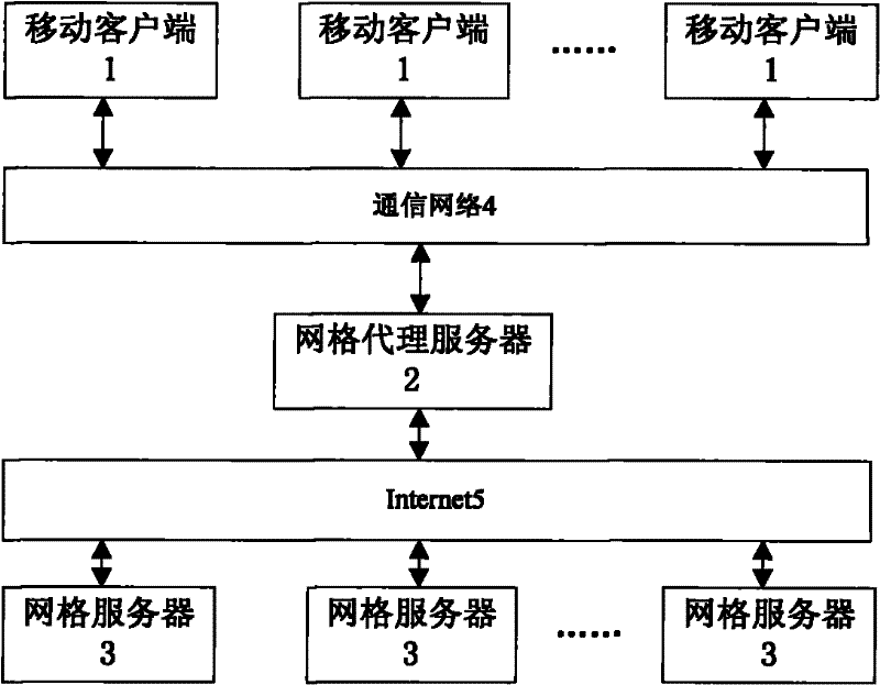
[0026] Such as figure 1 As shown, a geographic index-based spatial information service system includes a grid server 3, a mobile client 1, and a grid proxy server 2. The mobile client 1 is connected to the grid proxy server 2 through a communication network 4, Described grid server 3 is connected with grid proxy server 2 through Internet 5, and described grid server 3 is provided with the first spatial information local indexing mechanism, and described mobile client 1 is provided with the second information local indexing mechanism , the grid proxy server 2 is provided with a global distributed index mechanism, the grid server 3 registers with the grid proxy server 2, and sends its own spatial resource related information to the grid proxy server 2, the network The grid proxy server 2 stores the global index information of spatial resources...


PUM


Abstract

The invention relates to a spatial information service based on a geographical index, comprising a grid server, a mobile client and a grid agent server; the grid server is provided with a first spatial information local index mechanism; the mobile client is provided with a second information local index mechanism; the grid agent server is provided with a globally distributed index mechanism; the grid server registers on the grid agent server, and simultaneously sends the relevant information of a respective spatial resource to the grid agent server; the grid agent server stores the global index information of the spatial resource of each grid server; the mobile client sends the request of spatial information mobile grid service to the grid agent server; and the grid agent server judges which grid server of requested data to send the request to the owned grid server according to the requested place information. Compared with the prior art, the spatial information service based on the geographical index has the advantages of promoting the locating speed of spatial information resources, and the like.

Description

technical field [0001] The invention relates to a spatial information service system, in particular to a geographic index-based spatial information service system. Background technique [0002] In the service of spatial information, WebGIS enables people to share and serve spatial information based on the Internet. However, the traditional GIS and WebGIS architectures are closed, most of them are based on a single system C / S or B / S structure, and different WebGIS have no cooperation, which makes people build GIS at a huge cost. The system is like isolated islands on the data / information ocean, which hinders the full sharing and mobile services of spatial information, resulting in a situation of "massive data and insufficient information". Grid (Grid) attempts to realize the comprehensive connection of various resources on the Internet, and finally realize resource sharing and collaborative work in the network virtual environment, and eliminate resource islands or informatio...

Claims


Application Information

Patent Timeline
Patent Type & Authority Applications(China)
IPC IPC(8): G06F17/30
Inventor 陈鹏童小华田根何兵
Owner TONGJI UNIV
Why Eureka
Try Eureka