Method for automatically generating virtual navigation mark on electronic navigation channel chart according to water level change

A technology of electronic navigation map and water level change, applied in the field of river navigation map

Active Publication Date: 2012-02-22
广西远长公路桥梁工程有限公司
View PDF5 Cites 16 Cited by
  • Summary
  • Abstract
  • Description
  • Claims
  • Application Information

AI Technical Summary

Problems solved by technology

This method has two disadvantages. One is that the virtual buoy cannot reflect the change of water level in time; the other is that the download process is troublesome, which increases the workload of the crew and the cost of broadband usage.

Method used


Image

  • Method for automatically generating virtual navigation mark on electronic navigation channel chart according to water level change
  • Method for automatically generating virtual navigation mark on electronic navigation channel chart according to water level change
  • Method for automatically generating virtual navigation mark on electronic navigation channel chart according to water level change

Examples


Embodiment Construction

[0052] The present invention will be further described below in conjunction with the accompanying drawings and specific embodiments.

[0053] Further illustrate the present invention below in conjunction with accompanying drawing and specific embodiment:

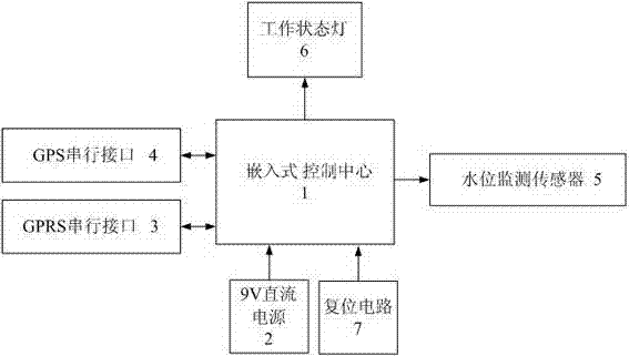
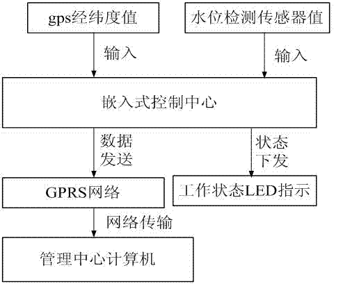
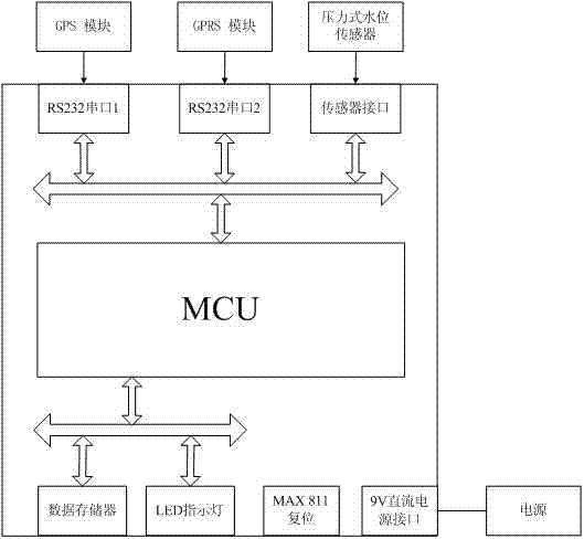
[0054] 1. Reference figure 1 , a water level automatic remote control detection device is composed of 1. embedded control center, 2. working DC power supply, 3.GPRS module, 4.GPS module, 5. water level pressure sensor, 6. remote management center computer, and its working steps are as follows :

[0055] a. The device is packaged in a metal box and connected to the water level sensor and solar power supply through a shielded cable.

[0056] b. The embedded control center is connected to the working power supply module. After the power supply, the embedded control center starts to work, circularly detects the changes of various module parameters, calculates and analyzes the detection results and sends the information to the...


PUM


Abstract

The present invention discloses a method for automatically generating a virtual navigation mark on an electronic navigation channel chart according to water level change. According to the method, an automatic water level remote control detection device with GPS positioning is installed on a river reach; the automatic water level remote control detection device transmits detected water level information to a computer in a management center; the computer in the management center receives and releases the water level data; a terminal computer automatically generates a virtual navigation mark based on the existing electronic map layer information according to the water level data, and displays new virtual navigation mark information on the electronic navigation channel chart. With the present invention, the remote and real time monitoring of the water level of the river can be easily performed by the navigational fair department and the water conservancy department, the management department can real timely view the water level of the key point of the river, the virtual navigation mark can be automatically generated according to the water level change, and the safety guarantee is provided for ship navigation.

Description

technical field [0001] The invention relates to a river channel map, in particular to a method for automatically detecting, sending and receiving a river water level and automatically generating a virtual navigation mark according to the received water level. technical background [0002] A navigation mark is a kind of transportation facility installed in rivers, lakes and oceans to ensure safe navigation of ships, avoid dangerous areas, and guide navigation. It has played a great role in the development of shipping. As a large water country with vast sea area and numerous rivers and lakes, my country's shipping industry has developed rapidly. However, the development of shipping economy is restricted by the safety of navigation, which requires the navigation mark business to continuously innovate and adapt to the development of shipping economy. According to incomplete statistics, as of the end of 2008, my country has set up more than 40,000 navigation buoys of various typ...

Claims


Application Information

Patent Timeline
Patent Type & Authority Applications(China)
IPC IPC(8): G01C21/00G01F23/00G01S19/42G08C17/02
Inventor 陈向进李文勇崔更申
Owner 广西远长公路桥梁工程有限公司
Why Eureka
Try Eureka