Remote-sensing aerial surveying elevation fitting method

An elevation and aerial survey technology, which is applied in the field of remote sensing aerial survey elevation fitting, can solve the problems that cannot meet the requirements of large-scale topographic map measurement specifications, large elevation errors, and low elevation accuracy.

Active Publication Date: 2012-07-18
CENT SOUTHERN CHINA ELECTRIC POWER DESIGN INST CHINA POWER ENG CONSULTING GROUP CORP
View PDF1 Cites 6 Cited by
  • Summary
  • Abstract
  • Description
  • Claims
  • Application Information

AI Technical Summary

Problems solved by technology

At present, the remote sensing aerial survey platform has a large error between the elevation measured by the aerial survey office and the elevation measured by the total station and other field surveying instruments, which cannot meet the requirements of th

Method used


Image

  • Remote-sensing aerial surveying elevation fitting method
  • Remote-sensing aerial surveying elevation fitting method
  • Remote-sensing aerial surveying elevation fitting method

Examples


Embodiment Construction

[0041] Below in conjunction with accompanying drawing and specific embodiment the present invention is described in further detail:

[0042] refer to figure 1 As shown, the remote sensing aerial survey elevation fitting method includes the following steps:

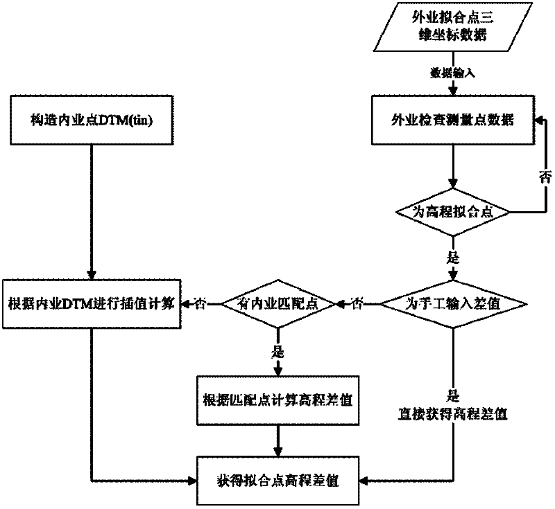
[0043] Step 1: Set up field-measured detection points, and use the three-dimensional coordinate data of field-measured detection points to determine the field-measured elevation surface;

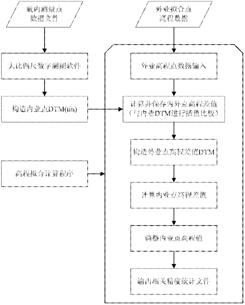
[0044] The second step: use the remote sensing aerial survey platform to measure the large-scale topographic map and extract the three-dimensional coordinate data of the large-scale topographic map;

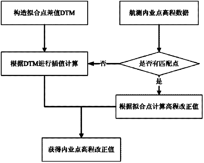
[0045] Step 3: Combined with the field measured elevation surface data values, the polynomial fitting model is used to fit the elevation of the three-dimensional coordinate data in the large-scale topographic map, and the elevation correction value of each point in the large-scale topographic map is obtained;

[0046] Step 4: Combining th...


PUM


Abstract

The invention relates to the technical field of power engineering survey, in particular to a remote-sensing aerial surveying elevation fitting method. The remote-sensing aerial surveying elevation fitting method comprises the following steps: setting a field surveyed monitoring point, surveying three-dimensional coordinate data of the monitoring point by using a field surveying instrument, and determining a field surveyed elevation surface; surveying a large-scale topographic map, extracting three-dimensional coordinate data of the large-scale topographic map; in combination with a data value of the field surveyed elevation surface, performing elevation fitting on the three-dimensional coordinate data of the large-scale topographic map by using a polynomial fitting model, and working out an elevation correcting value of each point in the large-scale topographic maps; and correcting the elevation data of the large-scale topographic map by a triangular planar fitting method to the field surveyed elevation surface so as to obtain the elevation value of each point in the large-scale topographic map. Through the adoption of the remote-sensing aerial surveying elevation fitting method, the elevation precision of the large-scale topographic map is effectively improved, thus meeting a requirement on the precision of the surveyed elevation of the large-scale topographic map in survey specifications.

Description

technical field [0001] The invention relates to the technical field of electric power engineering survey, belongs to the field of surveying and mapping science and technology, in particular to a remote sensing aerial survey elevation fitting method. Background technique [0002] Remote sensing aerial survey is mainly used to obtain high-precision topographic map data in real time. At present, the remote sensing aerial survey platform has a large error between the elevation measured by the aerial survey office and the elevation measured by the total station and other field surveying instruments, which cannot meet the requirements of the large-scale topographic map measurement specifications, especially in the various survey stages of power engineering. method, the height measurement accuracy of the topographic map is low, and there is no feasible method to solve this problem at present. Contents of the invention [0003] The purpose of the present invention is to provide a...

Claims


Application Information

Patent Timeline
IPC IPC(8): G01C5/00
Inventor 胡吉伦徐辉程正逢易祎王黎
Owner CENT SOUTHERN CHINA ELECTRIC POWER DESIGN INST CHINA POWER ENG CONSULTING GROUP CORP
Why Eureka
Try Eureka