An airborne interferometric synthetic aperture radar complex scene elevation inversion method and system

An interferometric synthetic aperture and complex scene technology, applied in the field of airborne interferometric synthetic aperture radar complex scene elevation inversion, can solve the problems of lack of elevation data, low elevation accuracy in low coherence areas, and difficult interferometric processing steps, so as to improve the elevation accuracy. , Improve the accuracy of elevation inversion and meet the needs of high-precision geographic surveying and mapping

Active Publication Date: 2022-03-08
BEIJING INST OF RADIO MEASUREMENT
View PDF9 Cites 0 Cited by
  • Summary
  • Abstract
  • Description
  • Claims
  • Application Information

AI Technical Summary

Problems solved by technology

) conditions, conventional interferometric processing cannot satisfy high-precision elevation inversion
At the same time, low-coherence areas such as overlap and shadow are more prominent in complex scenes, which causes great difficulties in the interference processing step. Traditional interference processing cannot obtain effective elevation data in low-coherence areas, which easily causes the lack of elevation data in the scene.
[0003] The current method of dealing with the height inversion of complex scenes mainly uses a single flight mode, then performs traditional interferometric processing for height inversion, and then directly interpolates the height information of the low-coherence area, resulting in low height accuracy of the low-coherence area. Unable to meet the needs of high-precision geographic surveying and mapping

Method used


Image

  • An airborne interferometric synthetic aperture radar complex scene elevation inversion method and system
  • An airborne interferometric synthetic aperture radar complex scene elevation inversion method and system
  • An airborne interferometric synthetic aperture radar complex scene elevation inversion method and system

Examples


Embodiment Construction

[0031] The principles and features of the present invention are described below in conjunction with the accompanying drawings, and the examples given are only used to explain the present invention, and are not intended to limit the scope of the present invention.

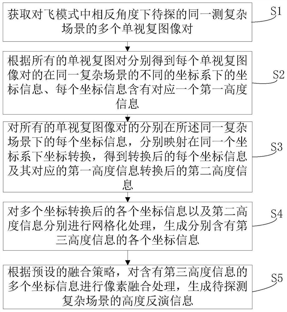
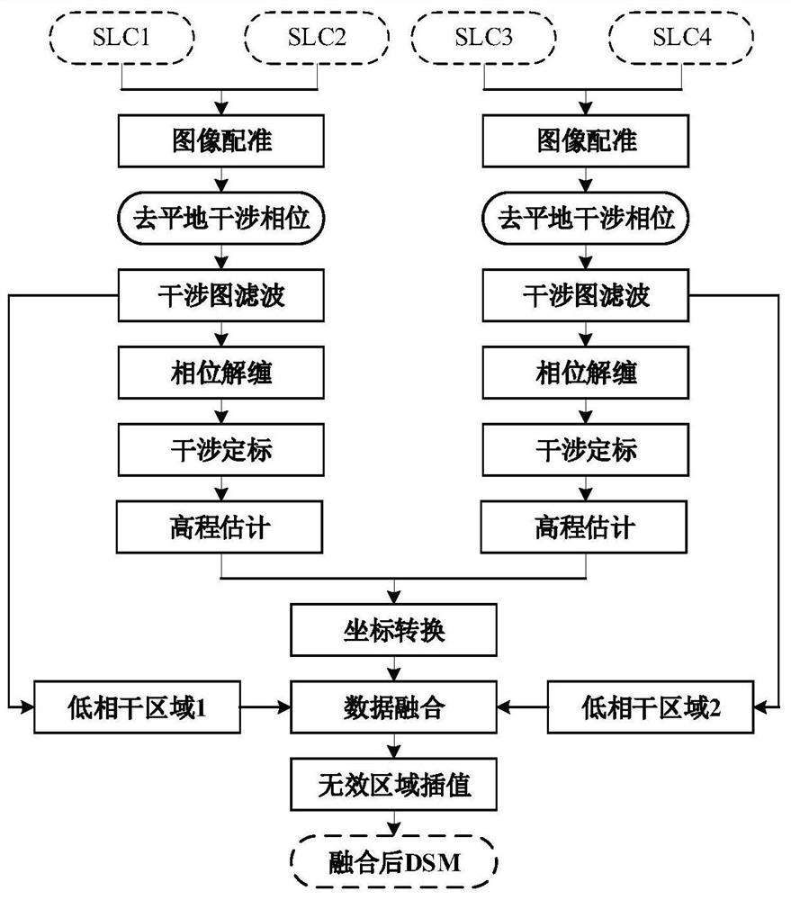
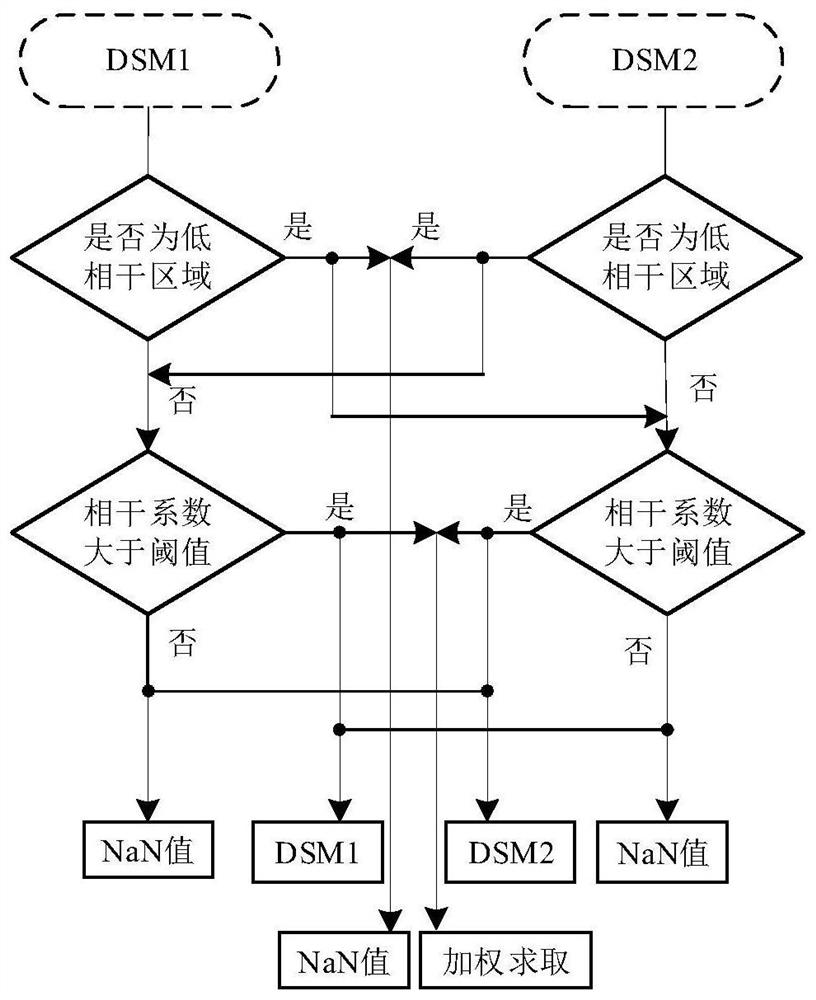
[0032] Such as Figure 1-Figure 11 as shown, figure 1 One of the schematic flow charts provided for the embodiment of the complex scene elevation inversion method of the present invention; figure 2 The overall schematic diagram provided for other embodiments of the complex scene elevation inversion method of the present invention, wherein SLC represents a single-view complex image pair, and SLC1 and SLC2 are single-view complex images acquired for the first flight to form a single-view complex image pair, SLC3 and SLC4 are single-view complex images acquired in the second flight, forming a single-view complex image pair, and DSM stands for digital surface model; image 3 Schematic diagram of the data fusion metho...


PUM


Abstract

The invention provides an airborne interferometric synthetic aperture radar complex scene elevation inversion method and system, the method comprising: obtaining a plurality of single-view complex image pairs of the same complex scene to be detected at opposite angles in the fly-by-flight mode; All single-view complex image pairs obtain coordinate information in different coordinate systems of each single-view complex image pair, and each coordinate information contains a corresponding first height information; for each coordinate of all single-view complex image pairs Information, respectively mapped in the same coordinate system for coordinate conversion, to obtain each coordinate information after conversion and the second height information after conversion of the corresponding first height information; for each coordinate information after multiple coordinate conversions and the second height information The height information is gridded separately to generate each coordinate information containing the third height information; according to the preset fusion strategy, pixel fusion processing is performed on multiple coordinate information containing the third height information to generate the coordinate information of the complex scene to be detected. Highly inverted information.

Description

technical field [0001] The invention relates to the field of airborne interferometric synthetic aperture radar, in particular to an elevation inversion method and system for an airborne interferometric synthetic aperture radar complex scene. Background technique [0002] Elevation inversion of complex scenes is a key problem to be solved by airborne interferometric synthetic aperture radar. Elevation inversion. At the same time, low-coherence areas such as overlapping and shadows are more prominent in complex scenes, which has caused great difficulties in the interferometric processing step. Traditional interferometric processing cannot obtain effective elevation data in low-coherence areas, which easily causes the lack of elevation data in the scene. [0003] The current method of dealing with the height inversion of complex scenes mainly uses a single flight mode, then performs traditional interferometric processing for height inversion, and then directly interpolates the...

Claims


Application Information

Patent Timeline
Patent Type & Authority Patents(China)
IPC IPC(8): G01S13/90G01S7/41G01C5/00
CPCG01S13/90G01S13/9094G01S13/9023G01S7/418G01C5/00
Inventor 张斌郑浩韦立登李爽
Owner BEIJING INST OF RADIO MEASUREMENT
Why Eureka
Try Eureka