A 3D city modeling method based on bim and gis

A city modeling and city model technology, applied in the field of 3D city modeling based on BIM and GIS, can solve the problem of inability to take into account geographic data processing, analysis capabilities, strong dependence on the technical level of modelers, and building model elevation accuracy. To achieve the effect of good quality of urban modeling, perfect elevation information of ground objects, and strong timeliness

Active Publication Date: 2022-05-17
GUANGDONG BOZHILIN ROBOT CO LTD
View PDF0 Cites 0 Cited by
  • Summary
  • Abstract
  • Description
  • Claims
  • Application Information

AI Technical Summary

Problems solved by technology

[0003] The construction of traditional 3D city models mainly relies on commercialized computer-aided design software, and adopts a large number of manual interactive modeling methods. For large-scale urban scenes, this method has long production cycle, high cost, difficult update, poor timeliness, and poor timeliness. Problems such as strong dependence on the technical level of modelers have become one of the important bottlenecks restricting the development of digital cities, and traditional 3D city modeling obtains building heights through visual estimation or manual measurement to model. There are problems such as lack of elevation information of ground objects, poor elevation accuracy of building models, and poor roof fineness. At the same time, traditional 3D urban modeling cannot take into account the internal design and implementation of buildings in the microscopic field and the geographic data processing and analysis capabilities in the macroscopic geographic environment. , therefore, the present invention proposes a three-dimensional city modeling method based on BIM and GIS to solve the problems existing in the prior art

Method used


Image

  • A 3D city modeling method based on bim and gis

Examples


Embodiment Construction

[0033] In order to make the technical means, objectives, and effects of the invention easy to understand, the present invention will be further described below in conjunction with specific embodiments.

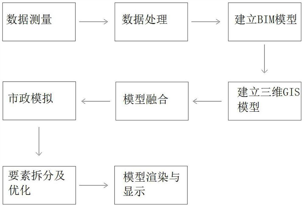
[0034] Such as figure 1 As shown, the present embodiment provides a three-dimensional city modeling method based on BIM and GIS, and the specific steps are as follows:

[0035] Step 1: Data Measurement

[0036] Install cameras, infrared scanning sensors and lidar on multiple groups of drones, use multiple groups of drones to scan over the city, and collect GIS data, including physical objects such as artificial buildings and natural geographic locations, and spatial parameter information, including Buildings, roads, terrain, trees, waters and bridges, record and shoot urban building dimensions, external color textures, and obstacles, before drone aerial survey operations, determine the project aerial survey in the drone's built-in Google Earth Range, comprehensive flight con...


PUM


Abstract

The invention discloses a three-dimensional city modeling method based on BIM and GIS, comprising the following steps: data measurement, data processing, establishment of a BIM model, establishment of a three-dimensional GIS model, model fusion, municipal simulation, element splitting and optimization, model rendering and Display; the present invention can easily obtain the precise height, appearance size and internal space information of the building through BIM, thus integrating BIM and GIS, first modeling the building, and then sharing the building space information with its surrounding geographical environment, and applying it to the three-dimensional city In GIS analysis, the cost of building space information can be reduced without a large amount of manual interactive modeling, and the use of unmanned aerial vehicles and unmanned vehicles to collect data has high efficiency, short production cycle and strong timeliness. At the same time, the present invention collects data Finally, through data classification and comparison, calculation and simulation of point cloud and aerial photo data, the elevation information of ground objects is improved, the elevation accuracy of building models is high, and the roof is more refined.

Description

technical field [0001] The invention relates to the field of architectural design, in particular to a three-dimensional city modeling method based on BIM and GIS. Background technique [0002] Digital city represents the development direction of urban informatization and is an important means to promote the informatization of the whole country. Since entering the 21st century, digital city has developed rapidly and has become one of the most potential strategic high-tech fields. , in various application systems of digital cities, the 3D city model is gradually replacing the 2D city map, and has become an important tool in many fields such as urban planning, urban management, public safety, heritage protection, traffic navigation, tourism and vacation, military defense, film and television entertainment, etc. The expression form of basic geospatial information. [0003] The construction of traditional 3D city models mainly relies on commercialized computer-aided design softw...

Claims


Application Information

Patent Timeline
Patent Type & Authority Patents(China)
IPC IPC(8): G06T17/05G06T15/00G06T15/04G06T19/00G06F16/29
CPCG06T15/005G06T15/04G06T17/05G06T19/003G06T2200/08
Inventor 孙军杨泓斌胡高梁艺光郑泽杭
Owner GUANGDONG BOZHILIN ROBOT CO LTD
Why Eureka
Try Eureka