Rapid extraction and reconstruction method for data power line of airborne LIDAR

A power line and data technology, applied in the field of surveying and mapping, can solve the problem of point cloud sparse data being inapplicable, and achieve the effects of improving inspection efficiency, high extraction efficiency, and avoiding accidents

Inactive Publication Date: 2012-07-18
CHINESE ACAD OF SURVEYING & MAPPING
View PDF3 Cites 62 Cited by
  • Summary
  • Abstract
  • Description
  • Claims
  • Application Information

AI Technical Summary

Problems solved by technology

The extraction rate of this method reaches 93.8%, but it is not suitable for data with sparse point clouds
The power line detection module in Finland's Terrasolid software can realize the detection of power lines and the distance measurement to ground objects, but it

Method used


Image

  • Rapid extraction and reconstruction method for data power line of airborne LIDAR
  • Rapid extraction and reconstruction method for data power line of airborne LIDAR
  • Rapid extraction and reconstruction method for data power line of airborne LIDAR

Examples


Embodiment Construction

[0021] In order to describe the technical content, structural features, achieved goals and effects of the present invention in detail, the following will be described in detail in conjunction with specific embodiments and accompanying drawings.

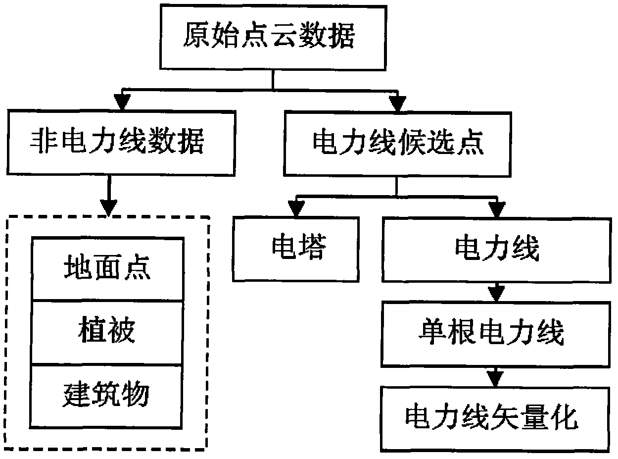
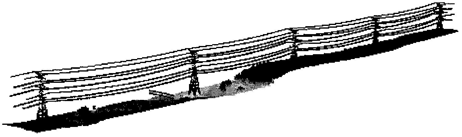
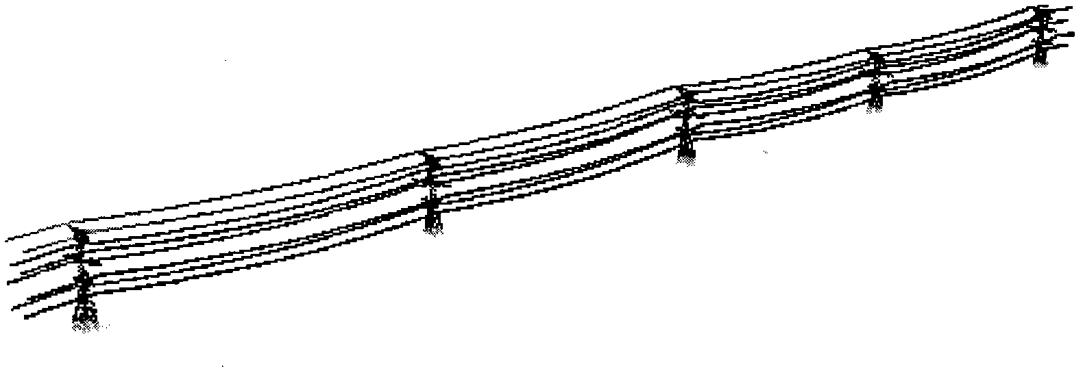
[0022] The specific flowchart of extracting and reconstructing power lines from airborne LIDAR (lidar) data is as follows: figure 1 shown. The power line must first solve the problem of separating the power line point cloud from a large number of original laser point clouds, that is, to separate the non-power line point cloud data (such as figure 1 ground points, vegetation and buildings, etc.) and power line data, and remove the tower from the candidate point cloud of the power line. Secondly, according to the spatial characteristics of the power line, the direction of the power line is judged, and the data of a single power line is identified from the data points of the power line. Finally, vectorize the power line data and perfor...


PUM


Abstract

The invention provides a rapid extraction and reconstruction method for a data power line of an airborne LIDAR. The method comprises the following steps of: acquiring a large amount of laser point cloud data by using an airborne laser radar measurement system, and filtering the laser point cloud data by properly setting an elevation threshold value to reject point cloud data not formed by a power line; after the filtration of the point cloud data is finished, rejecting a pylon according to the variation characteristics of point cloud density on the two sides of the pylon; counting the point number of each layer of power line in the point cloud data of the power line by adopting a histogram counting analysis method, layering the power line, and fitting the power line in the same layer, thereby separating point cloud data on a single power line; and fitting the power lines by utilizing a catenary equation, estimating a catenary equation parameter, and finally realizing the vectorization of the power line. By the method, automatic power line extraction and pylon extraction between a plurality of spans can be rapidly realized, and extraction efficiency is high; and the method can be used for the transmission line safety inspection of a power sector, and transmission line inspection efficiency is greatly improved.

Description

technical field [0001] The invention relates to the technical field of surveying and mapping, and more specifically, to a method for fast extraction and reconstruction of airborne LIDAR data power lines. Background technique [0002] The spatial positioning measurement accuracy of the current helicopter line inspection technology is not high, and the helicopter equipped with the LIDAR (light radar) system can just solve this problem better. The airborne LIDAR system can obtain aerial digital images and laser point cloud data, and the data can be processed to detect safety faults on the ground and objects in the transmission line corridor. At present, the laser radar system has been used in the survey, design and maintenance of the power grid in foreign countries, while our country is in its infancy. [0003] Lidar technology detects power lines, the key is the identification and reconstruction of power lines. At present, some scholars have studied this and achieved certain...

Claims


Application Information

Patent Timeline
IPC IPC(8): G01S17/89G01S7/48
Inventor 刘正军梁静张继贤左志权
Owner CHINESE ACAD OF SURVEYING & MAPPING
Why Eureka
Try Eureka