An Atmospheric Correction Method for Remote Sensing Satellite Multispectral Data

A technology for atmospheric correction and remote sensing satellites, applied in radio wave measurement systems, instruments, etc., can solve problems such as different characteristics, research purposes and requirements, differences, etc., to achieve high accuracy, reduced production time, and complete methods.

Active Publication Date: 2011-12-21
CHINA CENT FOR RESOURCES SATELLITE DATA & APPL
View PDF5 Cites 23 Cited by
  • Summary
  • Abstract
  • Description
  • Claims
  • Application Information

AI Technical Summary

Problems solved by technology

[0004] At present, there are many achievements in atmospheric correction abroad. Other foreign remote sensing satellites such as LANDSAT, SPOT, MODIS, and ASTER have carried out corresponding atmospheric corrections according to the characteristics of their respective satellites; Atmospheric correction research of domestic remote sensing satellite data has produced some related algorithms, but due to the rapidly changing atmospheric conditions, the influence and importance of the local atmosphere on remote sensing data are different at that time, and the sensor band settings of each satellite are different, and the characteristics are different. The purpose and requirements of research are also different. Even in the same area, the atmospheric conditions are complex and changeable, and the atmospheric conditions of each image are also significantly different. It is difficult to have an algorithm that is universally applicable.

Method used


Image

  • An Atmospheric Correction Method for Remote Sensing Satellite Multispectral Data
  • An Atmospheric Correction Method for Remote Sensing Satellite Multispectral Data
  • An Atmospheric Correction Method for Remote Sensing Satellite Multispectral Data

Examples


Embodiment Construction

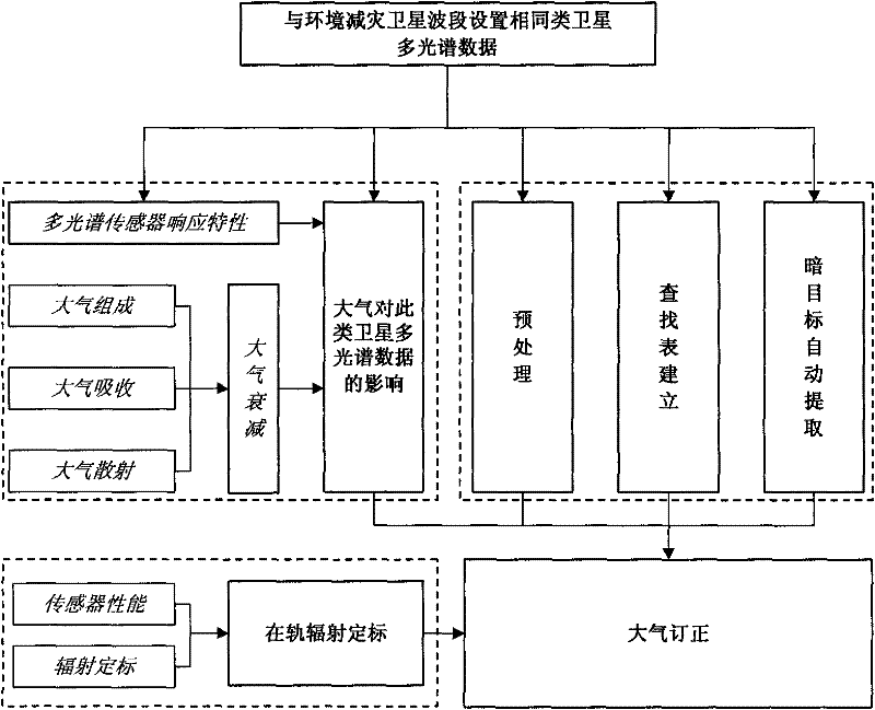
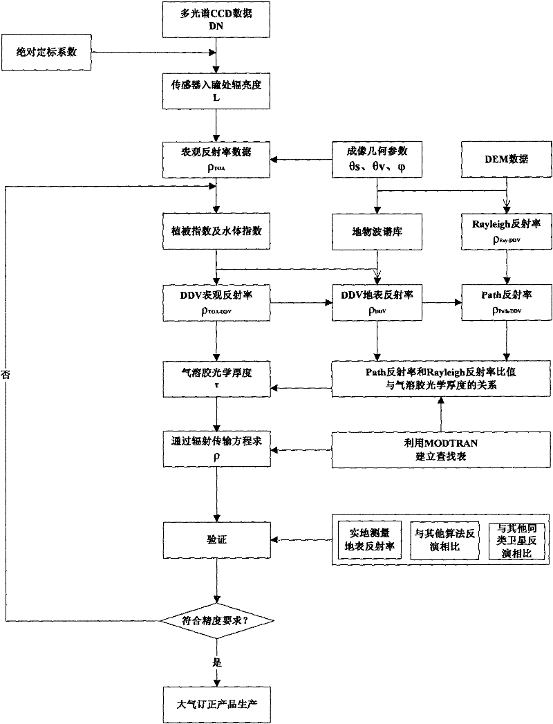
[0030] Such as figure 1 , 2 Shown, the atmospheric correction method of a kind of remote sensing satellite multispectral data of the present invention, the steps are as follows:

[0031] (1) Read the multispectral data of remote sensing satellites, preprocess the multispectral data, and convert the multispectral data into apparent radiance data and apparent reflectance data;

[0032] (1.1) Apparent radiance

[0033] Read the multispectral CCD data, and calculate the radiance at the entrance pupil of the multispectral sensor, that is, the apparent radiance, according to the formula ① according to the absolute calibration coefficient in the attached file of the data:

[0034] L ( λ ) = DN ( λ ) A ( λ ) ...


PUM


Abstract

The invention discloses an atmospheric correction method for multispectral data of a remote sensing satellite. The method comprises the following steps of: (1) reading data, and converting the data into apparent radiance data and apparent reflectivity data; (2) calculating decision factors, i.e. a ratio vegetation index, a soil adjustable vegetation index and a normalization water body index in adecision tree method according to the apparent reflectivity data; (3) acquiring apparent reflectivity data in a dark target area according to the apparent reflectivity data, and calculating air path reflectivity; (4) determining the aerosol optical depth of each multispectral waveband according to the relation among the air path reflectivity, a Rayleigh reflectivity ratio and the aerosol optical depth, and determining the total optical depth of a position of 550 nanometers according to the aerosol optical depth and the Rayleigh scatting optical depth of each multispectral waveband; and (5) acquiring an inversion parameter from a lookup table according to the total optical depth of the position of 550 nanometers, and solving land surface reflectivity through a radiative transfer equation to finish atmospheric correction.

Description

technical field [0001] The invention relates to an atmospheric correction method for remote sensing satellites, in particular to an atmospheric correction method for multi-spectral data of satellites with similar sensor band settings to environmental disaster reduction satellites. Background technique [0002] Since its launch, environmental disaster reduction satellites have played a unique role in disaster monitoring such as Wenchuan earthquake continuous detection, Indian Ocean tsunami disaster monitoring, Australian fire monitoring, Japanese earthquake and tsunami disaster monitoring, and are widely used in agriculture, forestry, water conservancy, and land use. , ground condition survey, urban planning and many other fields have achieved remarkable results. In order to realize the comparison and application of remote sensing data obtained by different locations, different times and different sensors, and provide accurate and scientific decision-making basis for national...

Claims


Application Information

Patent Timeline
Patent Type & Authority Applications(China)
IPC IPC(8): G01S7/497G01S7/48
Inventor 王爱春傅俏燕闵祥军李杏朝潘志强韩启金
Owner CHINA CENT FOR RESOURCES SATELLITE DATA & APPL
Why Eureka
Try Eureka