Automatic generation method of interactive three dimensional city panoramic map

An automatic generation, panoramic map technology, applied in the field of spatial information, can solve the problem that navigation information is difficult to provide spatial information, etc.

Inactive Publication Date: 2012-09-12
BEIJING NORMAL UNIVERSITY
View PDF0 Cites 31 Cited by
  • Summary
  • Abstract
  • Description
  • Claims
  • Application Information

AI Technical Summary

Problems solved by technology

For another example, based on navigation voice prompts, users can predict information about occluded features, but currently navigation information is difficult to provide spatial information in complex situations

Method used


Image

  • Automatic generation method of interactive three dimensional city panoramic map
  • Automatic generation method of interactive three dimensional city panoramic map
  • Automatic generation method of interactive three dimensional city panoramic map

Examples


Embodiment 1

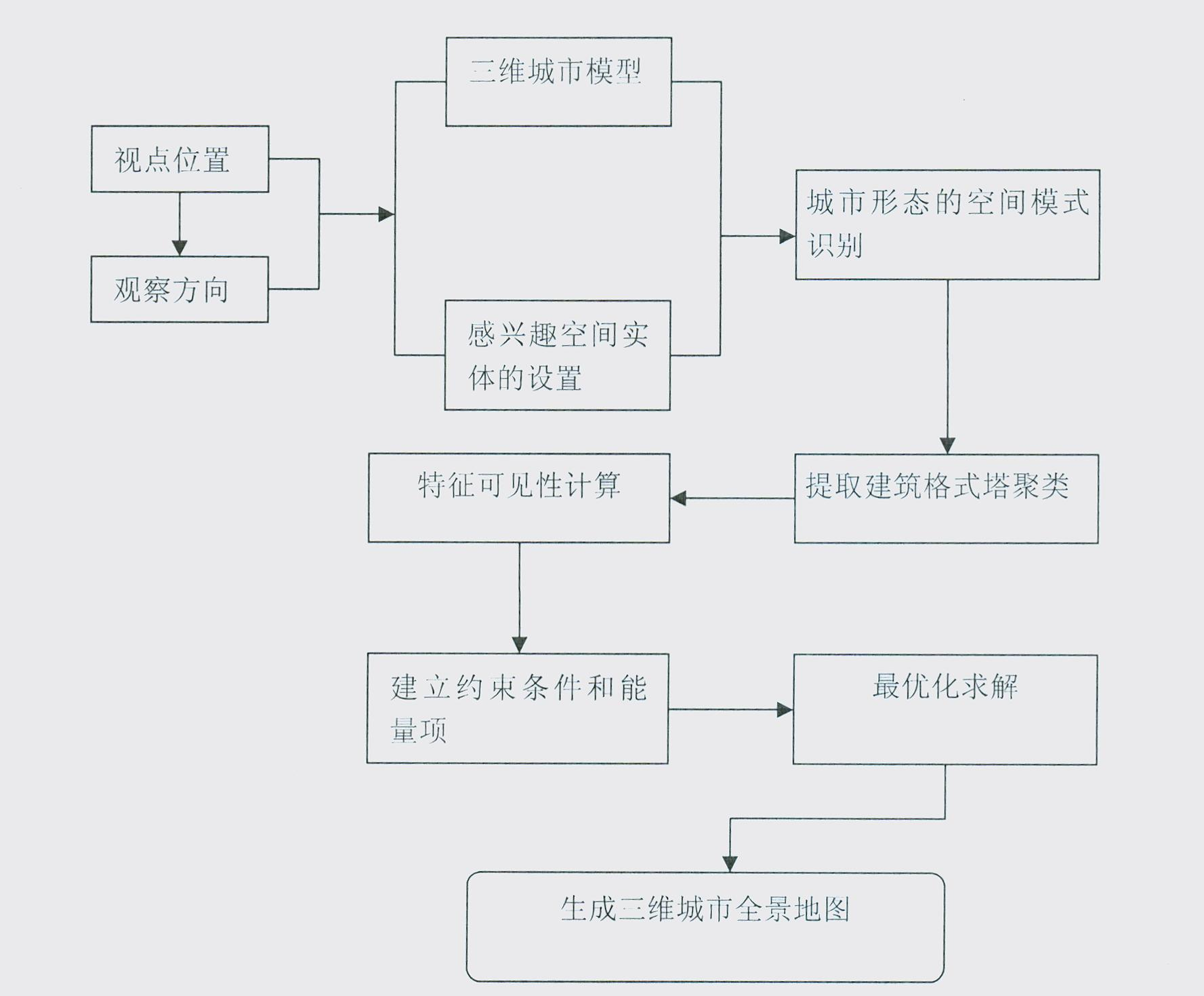
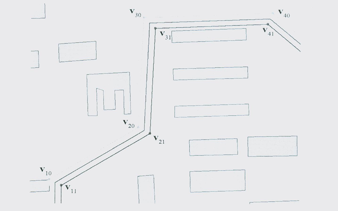
[0262] The method of the present invention is implemented by adopting a piece of terrain and building data (1608 buildings and 1096 road vertices in total) in the urban area of ​​Haidian District, Beijing. In order to fully illustrate the efficiency of the present invention, only the flat-top model of the building without superimposed textures is drawn, while the road data is represented by linear strips. Without panorama view mode turned on, the system can hit a frame rate of nearly 110fps.

[0263] In the panorama view mode, the method of the present invention can still achieve an interactive rate, and the three-dimensional city scene can run at an interactive rate of about 30-40fps. The main calculations in the preprocessing process include urban spatial cognition analysis, establishment of sparse positive definite matrix, calculation of its Cholesky decomposition, and matrix inversion. It takes 1.86 seconds to create DT subgraph and extract Gestalt cluster. The sizes of ...


PUM


Abstract

The invention relates to an automatic generation method of an interactive three dimensional city panoramic map. Based on city morphology and gestalt theory, the method combines roads widening, viewpoint raising, building displacement and building height reducing with optimization method through establishing energy function deviating argument and shielding argument for estimating city space cognition and uses linearization constrained condition energy function to solve minimizing energy function in real time, therefore automatic generation of the interactive three dimensional city panoramic map is achieved. The making method of the three-dimensional digital city panoramic map is characterized by fast visualization speed and little deformation of city scenes, having broad application prospect in city navigation, space position service and the like.

Description

1. Technical field [0001] The invention relates to an automatic generation method of an interactive three-dimensional city panorama map, which belongs to the technical field of spatial information. 2. Background technology [0002] The 3D virtual geographic environment has great application value in the fields of space location service and scientific research. Compared with the two-dimensional electronic navigation map, the three-dimensional electronic navigation map is more intuitive for users, easy to interpret, and highly recognizable, and it also provides a first-person perspective. However, most of the current 3D electronic maps are perspective projections. This projection is designed based on the observation mode of the human eye and the camera to the objective world. It can truly reflect the shape of the objective world in the 3D space environment. The disadvantage is that this projection It will cause the landscape in the city to occlude each other. For example, fea...

Claims


Application Information

Patent Timeline
Patent Type & Authority Applications(China)
IPC IPC(8): G09B29/00G06T17/00G06T19/20
Inventor 张立强邓浩张良
Owner BEIJING NORMAL UNIVERSITY
Why Eureka
Try Eureka