Method for utilizing video files containing global positioning system (GPS) information to synchronously determine movement track

A technology for video file and video synchronization, applied in satellite radio beacon positioning systems, measuring devices, instruments, etc., can solve problems such as inconvenience, inability to obtain geographic location information in real time, and inability to obtain relevant image information, and to facilitate investigation and evidence collection. , the effect of easy query

Inactive Publication Date: 2012-09-19
代松
View PDF3 Cites 13 Cited by
  • Summary
  • Abstract
  • Description
  • Claims
  • Application Information

AI Technical Summary

Problems solved by technology

[0002] The existing map software can only determine the user's geographical location in real time, but cannot obtain the relevant image information of the user's geographical location. If the image information is recorded by the recorder, the geographical location information cannot be obtained in real time, let alone known The user's movement trajectory, which brings a lot of inconvenience to law enforcement activities such as investigation and evidence collection that have strict requirements on the format of evidence

Method used


Image

  • Method for utilizing video files containing global positioning system (GPS) information to synchronously determine movement track
  • Method for utilizing video files containing global positioning system (GPS) information to synchronously determine movement track
  • Method for utilizing video files containing global positioning system (GPS) information to synchronously determine movement track

Examples


Embodiment Construction

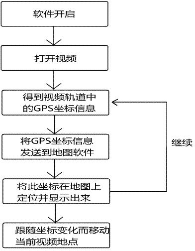
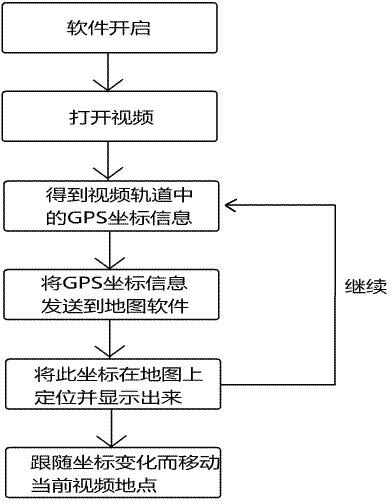
[0015] The present invention relates to a kind of method of the processing of image information, particularly utilize the method for synchronously determining motion locus of the video file that comprises GPS information, it is characterized in that comprising the following steps:

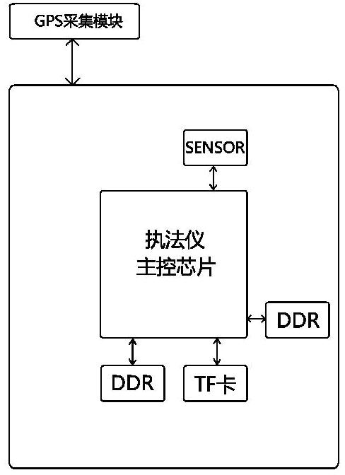
[0016] 1.1. During the process of collecting image information, the recorder collects the GPS data of the current location through the GPS module and writes it into the encoding track of the video H.264;

[0017] 1.2. Use the GPS video synchronous playback software to open the track video file that already contains GPS information, and play the video file and the map software built into the GPS video synchronous playback software on the same screen;

[0018] 1.3. Read the GPS coordinate information in the track video file during the video playback process;

[0019] 1.4. Send the coordinate information to the built-in map software of the GPS video synchronous playback software, and mark and display ...


PUM


Abstract

A movement track during video file shooting is determined synchronously through a method which comprises enabling global positioning system (GPS) data of a current site to be collected through a GPS module and written into an encoding track of video H.264 in the image information collecting process of a recorder, and then synchronously marking geographical position information on map software through GPS video synchronous play software in the playing process. The method has the advantages that not only can geographical position information and relevant image information of a users be obtained, but also the movement track of the user can be marked clearly.

Description

technical field [0001] The invention relates to a method for processing image information, in particular to a method for synchronously determining motion tracks using video files containing GPS information. Background technique [0002] The existing map software can only determine the user's geographical location in real time, but cannot obtain the relevant image information of the user's geographical location. If the image information is recorded by the recorder, the geographical location information cannot be obtained in real time, let alone known The user's movement track, which brings a lot of inconvenience to law enforcement activities such as investigation and evidence collection that have strict requirements on the format of evidence. Contents of the invention [0003] The purpose of the present invention is to provide a method for synchronously determining the motion trajectory using video files containing GPS information. Using this method, not only the user's geo...

Claims


Application Information

Patent Timeline
Patent Type & Authority Applications(China)
IPC IPC(8): G01S19/42G01C11/02
Inventor 代松
Owner 代松
Why Eureka
Try Eureka