Method and server for updating geographic location information
A geographical location information and server technology, applied in the field of updating geographical location information, can solve the problems of positioning accuracy error, poor user experience, deviation, etc., and achieve the effect of improving the low positioning accuracy
- Summary
- Abstract
- Description
- Claims
- Application Information
AI Technical Summary
Problems solved by technology
Method used
Image

Examples
Embodiment 1
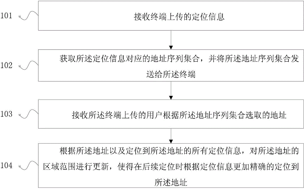
[0046] see figure 1 , the embodiment of the present invention proposes a method for updating geographic location information, including:
[0047] 101: Receive positioning information uploaded by the terminal;
[0048] 102: Obtain an address sequence set corresponding to the positioning information, and send the address sequence set to the terminal;
[0049] 103: Receive an address uploaded by the terminal and selected by the user according to the address sequence set;
[0050] 104: Update the area range of the address according to the address and all positioning information located to the address, so that the address can be located more accurately according to the positioning information during subsequent positioning.
[0051] The embodiment of the present invention continuously optimizes and updates the range of addresses in the map based on user positioning information and the specific address selected by the user based on the positioning information, and gradually improve...
Embodiment 2
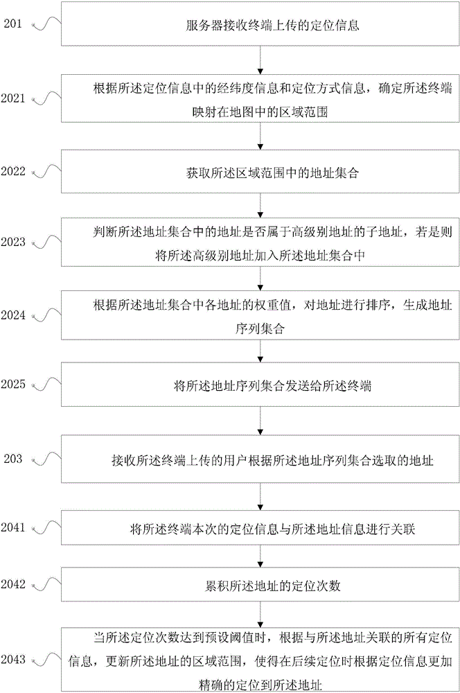
[0053] see figure 2 , the embodiment of the present invention proposes a method for updating geographic location information, including:
[0054] 201: The server receives the positioning information uploaded by the terminal.
[0055] After the terminal performs positioning, it will generate a set of positioning information. The positioning information includes at least the current latitude and longitude information (lat, lon) of the terminal, the current positioning mode information pos_type, and the model identifier model of the terminal to form a set, and the terminal reports the set to the server. The positioning method information pos_tpe is the identification of the positioning method adopted by the terminal. For example, the positioning can be performed through the GPS module of the terminal, and the positioning can be performed through AGPS (Assisted Global Positioning System, assisted global satellite positioning system). The positioning method is not limited here ....
Embodiment 3
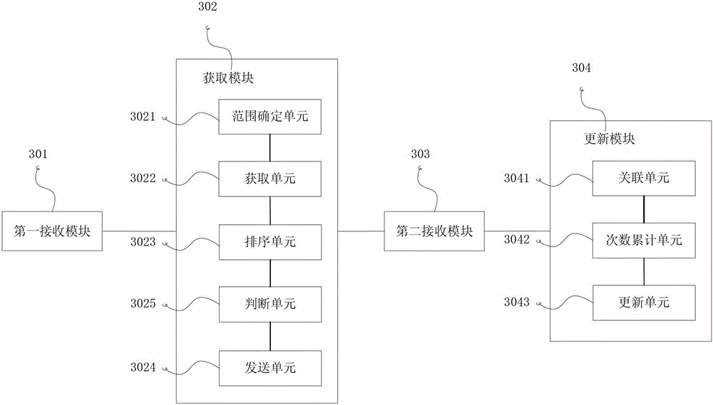
[0102] see image 3 , the embodiment of the present invention proposes a server for updating geographic location information, including:
[0103] The first receiving module 301 is configured to receive positioning information uploaded by the terminal;
[0104]An obtaining module 302, configured to obtain an address sequence set corresponding to the positioning information, and send the address sequence set to the terminal;
[0105] The second receiving module 303 is configured to receive the address uploaded by the terminal and selected by the user according to the set of address sequences;
[0106] The update module 304 is configured to update the area range of the address according to the address and all positioning information located to the address, so that the address can be located more accurately according to the positioning information during subsequent positioning.
[0107] In a specific implementation manner, the acquisition module 302 includes:
[0108] A range d...
PUM
 Abstract
Description
Claims
Application Information
 - Generate Ideas
- Intellectual Property
- Life Sciences
- Materials
- Tech Scout
- Unparalleled Data Quality
- Higher Quality Content
- 60% Fewer Hallucinations
Browse by: Latest US Patents, China's latest patents, Technical Efficacy Thesaurus, Application Domain, Technology Topic, Popular Technical Reports.
© 2025 PatSnap. All rights reserved.Legal|Privacy policy|Modern Slavery Act Transparency Statement|Sitemap|About US| Contact US: help@patsnap.com