Method for building CSG (Constructive Solid Geometry) model according to laser radar grid point cloud

A grid point cloud and laser radar technology, applied in the field of building CSG models, can solve the problems of large data volume of 3D models, difficult data visualization and other problems, and achieve the effect of improving efficiency

Inactive Publication Date: 2013-01-02
BEIJING UNIV OF CIVIL ENG & ARCHITECTURE
View PDF2 Cites 60 Cited by
  • Summary
  • Abstract
  • Description
  • Claims
  • Application Information

AI Technical Summary

Problems solved by technology

However, the data volume of these 3D models is relatively large, and it is not easy to perform data visualization operations efficiently.

Method used


Image

  • Method for building CSG (Constructive Solid Geometry) model according to laser radar grid point cloud
  • Method for building CSG (Constructive Solid Geometry) model according to laser radar grid point cloud
  • Method for building CSG (Constructive Solid Geometry) model according to laser radar grid point cloud

Examples


Embodiment Construction

[0048] The present invention will be further described in detail below in conjunction with the accompanying drawings, so that those skilled in the art can implement it with reference to the description.

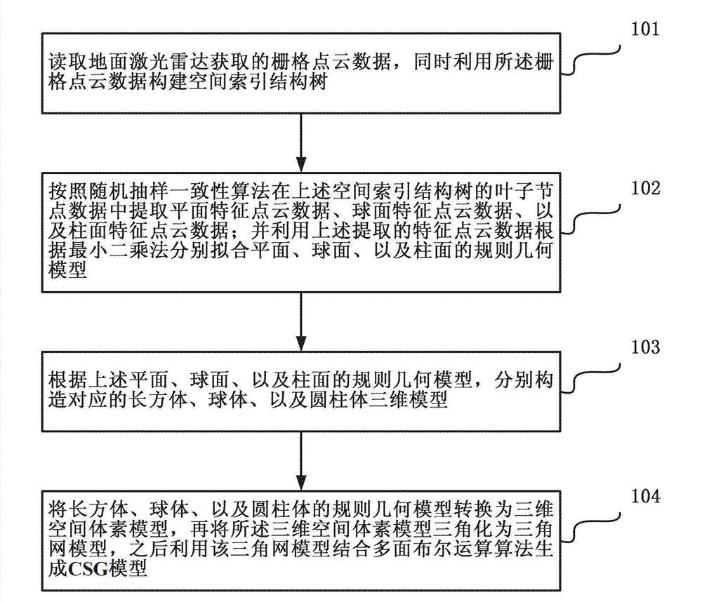
[0049] Such as figure 1 As shown, the method for constructing a CSG model according to the laser radar grid point cloud according to the present invention includes the following steps:

[0050] Step 101, read the grid point cloud data acquired by the ground laser radar, and use the grid point cloud data to construct a spatial index structure tree.

[0051] In the present invention, the data of the leaf nodes of the spatial index structure tree includes the three-dimensional minimum outer box information of the node, the two-dimensional row and column number outer rectangle information, the node name identification information, the identification information of the node storage point coordinates, and the three-dimensional coordinate offset parameter information.

[0052] In ...


PUM


Abstract

The invention discloses a method for building a CSG (Constructive Solid Geometry) model according to laser radar grid point cloud. The method comprises the steps of: reading grid point cloud data and building a spatial index structure tree by using the grid point cloud data; extracting the feature point cloud data of planes, spherical faces and cylindrical surfaces in leaf node data of the spatial index structure tree according to the random sampling consistency algorithm; fitting the regular geometrical models of planes, spherical faces and cylindrical surfaces according to the least square method by using the extracted feature point cloud data, and merging the models belonging to a same regular geometrical model; constructing the corresponding three-dimensional models of cuboids, spheres and cylinders according to the regular geometrical models of planes, spherical faces and cylindrical surfaces; and transforming the regular geometrical models of cuboids, spheres and cylinders into a three-dimensional spatial voxel model, then triangularizing the three-dimensional spatial voxel model into a triangulation network model, and subsequently generating the CSG model by using the triangulation network model and combining the polyhedral Boolean operation algorithm.

Description

technical field [0001] The invention relates to a method for constructing a CSG (constructive solid geometry, structured entity) model, in particular to a method for automatically constructing a CSG model based on a laser radar grid point cloud. Background technique [0002] Laser radar (LIDAR) is an advanced detection method combining laser technology and modern photoelectric detection technology. The laser radar measurement technology used for three-dimensional spatial information acquisition provides efficient technical support for the digital development of spatial information. Terrestrial lidar scanning data processing is one of the hottest research directions in the field of surveying and mapping in recent years. Among them, ground lidar data registration and modeling is the core content of data processing. The most original data stored in lidar scanning is the scanning step angle and the distance from the station to the target point. The scanned three-dimensional poi...

Claims


Application Information

Patent Timeline
Patent Type & Authority Applications(China)
IPC IPC(8): G06T17/10
Inventor 王晏民郭明罗勇
Owner BEIJING UNIV OF CIVIL ENG & ARCHITECTURE
Why Eureka
Try Eureka