Catchment area dividing method based on triangle patch

A triangular and watershed technology, applied in image analysis, image data processing, instruments, etc., can solve problems such as the rareness of triangular patch watershed divisions

Inactive Publication Date: 2013-02-06
吴立新 +2
View PDF2 Cites 9 Cited by
  • Summary
  • Abstract
  • Description
  • Claims
  • Application Information

AI Technical Summary

Problems solved by technology

[0004] To sum up, most of the current watershed divisions are based on grid DEM me

Method used


Image

  • Catchment area dividing method based on triangle patch
  • Catchment area dividing method based on triangle patch
  • Catchment area dividing method based on triangle patch

Examples


Embodiment Construction

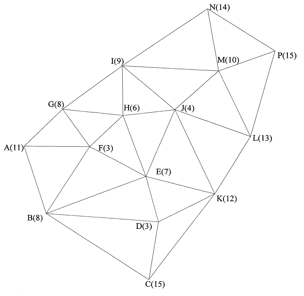
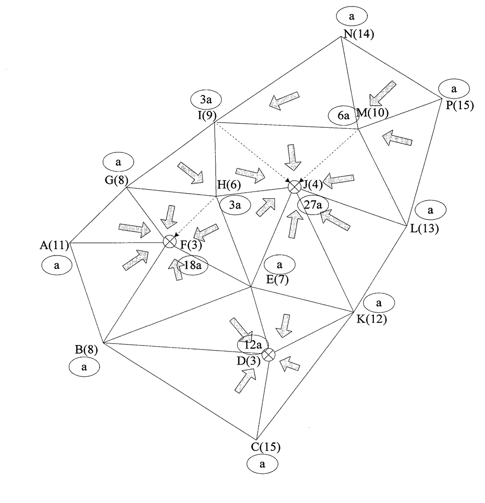
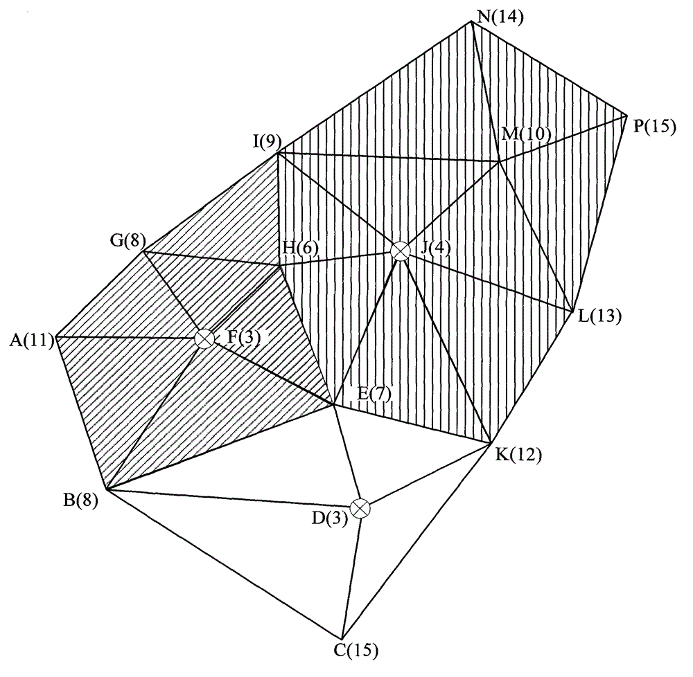
[0049] In order to illustrate the present invention more clearly, the present invention will be further described below in combination with examples of implementation and accompanying drawings. The content specifically described below is illustrative rather than restrictive, and should not limit the protection scope of the present invention.

[0050] It should be further explained that: the present invention relates to the comparison of the elevation value and the slope value. When the situation that the multi-point elevation value is equal or the multi-side slope value is equal, it can be sorted according to certain rules (such as by the ID size of the point number) . Other special case handling methods do not affect the overall content of the present invention, and the present invention should not be replaced, limited or improved by special case handling methods.

[0051] By adopting the above-mentioned content of the invention, the division result of the confluence path an...


PUM


Abstract

The invention discloses a catchment area dividing method based on a triangle patch, which comprises: 1) a confluence path extracting method based on a plane-point-side-point confluence mode that water of the triangle patch converges at the lowest point and then converges at the maximum side along slope; 2) a dividing method for marking a first-level catchment area of an upstream triangle based on the plane-point-side-point confluence mode; and 3) a multi-level catchment area dividing method for filling low-lying vertex in the catchment area based on the elevation of a catchment area water outlet. The catchment area dividing method based on the triangle patch can be applied to basin characteristic analysis of confluence path extraction, catchment area (multi-level) division and water outlet judgment of digital earth surface (comprising complex earth surface based on CD-triangulated irregular network (CD-TIN)) represented by the TIN, provides a new method for TIN-based digital elevation model (DEM) basin characteristic analysis, and can develop the corresponding software for the digital hydrological field (applied to urban waterlogging flood process simulation and simulated analysis).

Description

technical field [0001] The invention relates to a water catchment area division method based on a digital elevation model (Digital Elevation Model, DEM is divided into two expressions: Triangulated Irregular Network, TIN) and grid. More specifically, it relates to a watershed division method based on triangular patches. Background technique [0002] Catchment area, or catchment area, catchment basin, catchment basin, refers to the surface area where surface runoff or other substances flow through when they converge to a common water outlet. It is a closed area. The outlet is the point at which water leaves the catchment and is the lowest point on the catchment boundary. The terrain in a catchment that is lower than the surrounding land surface is called a depression. [0003] Catchments are the basis of hydrological analysis and the basic unit of research in fields such as watersheds and floods. Currently, there are two types of DEM-based watershed division methods: grid-...

Claims


Application Information

Patent Timeline
IPC IPC(8): G06T7/60
Inventor 吴立新李志锋张振鑫
Owner 吴立新
Why Eureka
Try Eureka