Automatic digital map correction method and device

A digital map and automatic technology, applied in the field of communication, can solve the problems of cumbersome correction process and poor correction accuracy, and achieve the effect of improving accuracy and good positioning server

Active Publication Date: 2013-04-03
LENOVO (BEIJING) CO LTD
View PDF4 Cites 20 Cited by
  • Summary
  • Abstract
  • Description
  • Claims
  • Application Information

AI Technical Summary

Problems solved by technology

[0004] The purpose of the embodiments of the present application is to provide a method and device for automatic correction of digital maps t

Method used


Image

  • Automatic digital map correction method and device
  • Automatic digital map correction method and device
  • Automatic digital map correction method and device

Examples


no. 1 example

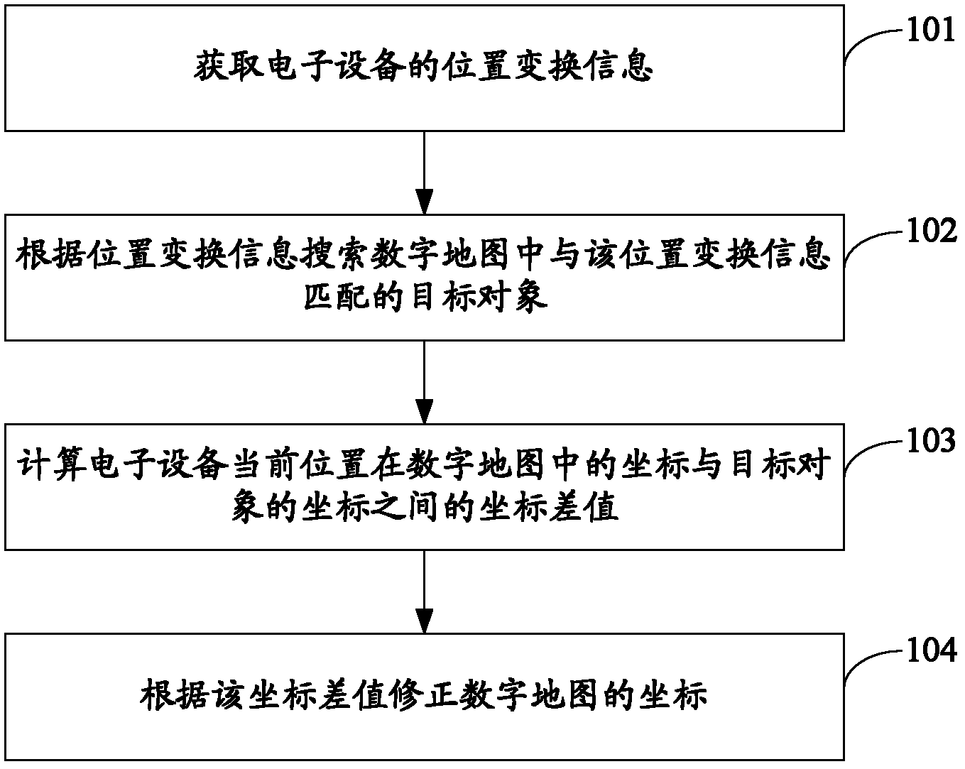
[0045] see figure 1 , is the flow chart of the first embodiment of the digital map automatic correction method of the present application:

[0046] Step 101: Obtain position transformation information of the electronic device.

[0047] The electronic device in this embodiment is usually installed on the vehicle, and is used to obtain the position change information of the vehicle in real time during the driving process of the vehicle, which is equivalent to obtaining the position change information of the electronic device. The electronic device can be specifically installed in An altitude recorder, an angle recorder or a GPS (Global Positioning System, Global Positioning System) navigation device, etc. on the vehicle.

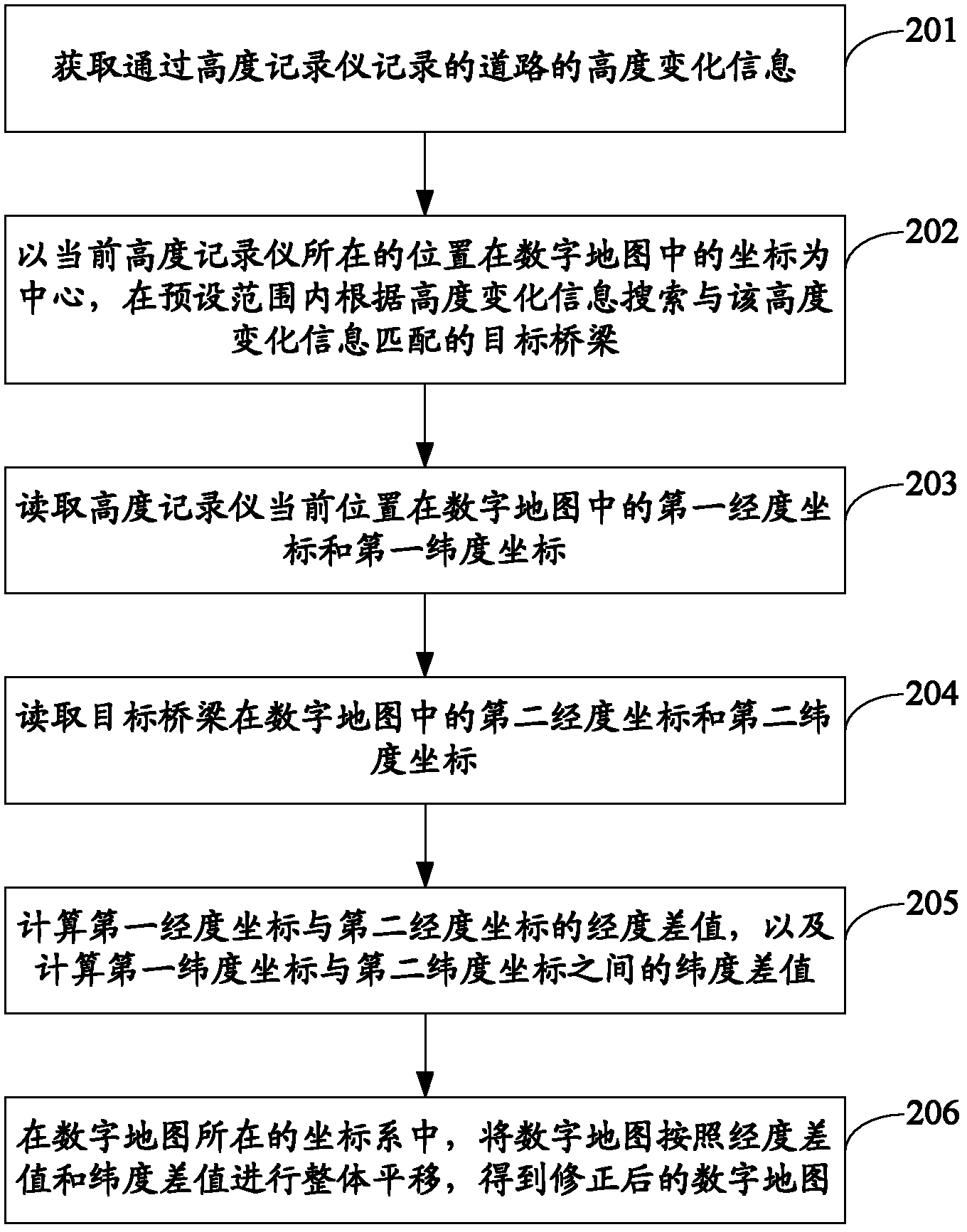
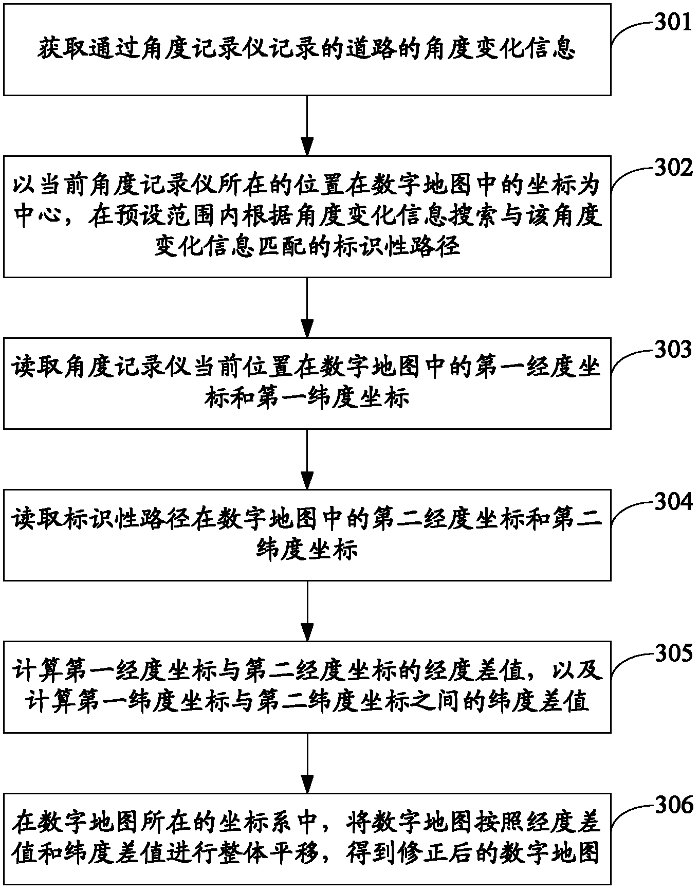
[0048] Wherein, when the electronic device is specifically an altitude recorder, the height change information of the road recorded by the altitude recorder is obtained; when the electronic device is specifically an angle recorder, the angle change informatio...


PUM


Abstract

The invention discloses an automatic digital map correction method and device. The method comprises the steps of: acquiring position conversion information of electronic equipment; according to the position conversion information, searching a target object matched with the position conversion information from a digital map; calculating the coordinate difference between the coordinate of the current position of the electronic equipment in the digital map and the coordinate of the target object; and correcting the coordinate in the digital map according to the coordinate difference. By applying the embodiment of the invention, the coordinate in the digital map can be automatically corrected by comparing the position conversion information recorded by the electronic device with the coordinate of the target object in the digital map; and the correction of the digital map can be conducted in real time by adopting the embodiment of the invention, and the overall coordinate of the digital map can be corrected, so that the accuracy of the digital map can be improved, and relatively good positioning servers can be provided for the digital map.

Description

technical field [0001] The present application relates to the field of communication technology, and in particular to a method and device for automatically correcting a digital map. Background technique [0002] In the prior art, many digital providers provide digital maps for users to use, such as Google Map, but the latitude and longitude on the digital maps often have certain errors. When the user uses GPS on Google Map, due to the existence of errors, it often shows that the user is not walking on the road, but walking in the building. In addition, due to national defense security reasons, the coordinate difference given by the digital map is often greater than 100m or more. [0003] In the process of researching the prior art, the inventor found that in order to avoid errors in the digital map, the coordinates in the digital map are usually corrected by manual correction. However, due to the troublesome manual correction, the scope of modification is limited. For exam...

Claims


Application Information

Patent Timeline
IPC IPC(8): G09B29/10
Inventor 马彬强
Owner LENOVO (BEIJING) CO LTD
Why Eureka
Try Eureka