A Spatiotemporal Quantitative Remote Sensing Fusion Method with Any Number of Sensors

A technology that integrates the number of sensors and space-time, and is used in instruments, image data processing, image enhancement, etc.

Active Publication Date: 2015-09-16
WUHAN UNIV
View PDF3 Cites 0 Cited by
  • Summary
  • Abstract
  • Description
  • Claims
  • Application Information

AI Technical Summary

Problems solved by technology

[0005] The problem to be solved by the present invention is to provide a spatiotemporal quantitative remote sensing fusion method for any number of sensors in view of the technical limitations of the existing observation system

Method used


Image

  • A Spatiotemporal Quantitative Remote Sensing Fusion Method with Any Number of Sensors
  • A Spatiotemporal Quantitative Remote Sensing Fusion Method with Any Number of Sensors
  • A Spatiotemporal Quantitative Remote Sensing Fusion Method with Any Number of Sensors

Examples


Embodiment Construction

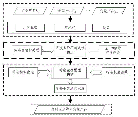
[0033] The technical scheme of the present invention can adopt computer software technology to realize automatic operation. The technical solution of the present invention will be described in detail below in conjunction with the drawings and embodiments.

[0034] Suppose there are quantitative remote sensing products S of n sensors 1 , S 2 ... S n For fusion, from S 1 to S n The spatial resolution decreases sequentially and the temporal resolution increases sequentially. Further assume that in the time series t 0 , t 1 ...t t-1 , t t Can get at least 1 scene S 1 , can get t+1 scene S n , which can obtain quantitative remote sensing products S with intermediate resolutions whose number increases sequentially (the specific number is determined by the time resolution). p (p=2,3,…,n-1), they have at least one reentry time at t 0 . In order to obtain quantitative remote sensing products with the highest spatio-temporal resolution from different sensors, the necessary ...


PUM


Abstract

The invention provides a space-time quantitative remote sensing fusion method of an arbitrary number of sensors. According to the space-time quantitative remote sensing fusion method of the arbitrary number of the sensors, quantitative remote sensing products of the arbitrary number of the sensors are fused to generate a quantitative remote sensing product which is simultaneously provided with highest space-time resolution rates of the sensors. Firstly, necessary preprocessing is conducted on the quantitative product. Secondly, uncertainty of scale difference of the quantitative products of different sensors is expressed accurately, an M estimation theory is combined to improve intra-class fitting precision, and accordingly spectrum scale difference is expressed accurately. Thirdly, windows are formed and centered in each pixel of each highest space-time resolution rate product, a similar pixel is screened in the window, and equal-weighted factors such as the spectrum scale difference are combined to construct a space-time fusion model. Finally, a variation framework is adopted to solve. According to the space-time quantitative remote sensing fusion method of the arbitrary number of the sensors, space-time complementary information and scale transition effect among the different sensors are utilized fully, correct description scale differences such as land cover types are considered, a fusion result is enabled to be close to a real quantitative product. Meanwhile, any auxiliary data are not required, and the fusion method is easy to achieve.

Description

technical field [0001] The present invention relates to the technical field of quantitative remote sensing information processing, in particular to a spatio-temporal quantitative remote sensing fusion method with an arbitrary number of sensors. For quantitative remote sensing products obtained by any sensor with complementary spatio-temporal information, the quantitative remote sensing of different scales of any sensor can be fused at the same time. products to achieve the purpose of simultaneously having high spatio-temporal resolution. Background technique [0002] Due to technical and financial constraints, remote sensing instruments need to balance time resolution and spatial resolution when designing, and the acquired remote sensing data and the inverted quantitative remote sensing products cannot have high temporal and spatial resolution characteristics at the same time. For example: geostationary satellite (GOES) temperature products have a time resolution of up to 15...

Claims


Application Information

Patent Timeline
Patent Type & Authority Patents(China)
IPC IPC(8): G06T5/50
Inventor 沈焕锋吴鹏海艾廷华
Owner WUHAN UNIV
Why Eureka
Try Eureka