GPS (global positioning system) terminal mileage statistical method based on satellite positioning technology

A GPS terminal, satellite positioning technology, applied in the field of sensing technology and the Internet of Things, can solve the problems of inaccurate information such as position and speed, GPS drift and other problems, and achieve the effect of improving the level of informatization

Active Publication Date: 2013-04-17
JIANGSU HONGXIN SYST INTEGRATION
View PDF5 Cites 15 Cited by
  • Summary
  • Abstract
  • Description
  • Claims
  • Application Information

AI Technical Summary

Problems solved by technology

Another reason is that the GPS occasionally drifts, resulting in inaccurate information such as position and speed obtained by the terminal.

Method used


Image

  • GPS (global positioning system) terminal mileage statistical method based on satellite positioning technology
  • GPS (global positioning system) terminal mileage statistical method based on satellite positioning technology
  • GPS (global positioning system) terminal mileage statistical method based on satellite positioning technology

Examples


Embodiment Construction

[0023] Below in conjunction with accompanying drawing, the present invention is described in further detail:

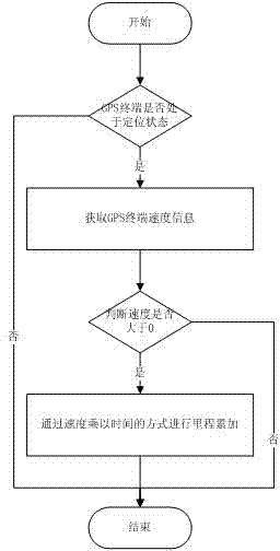
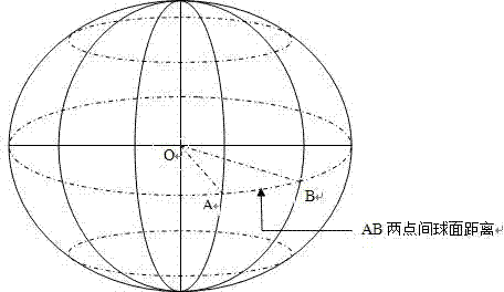
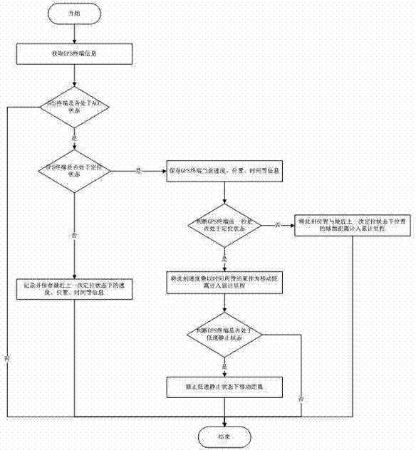
[0024] like image 3 As shown, the present invention designs a GPS terminal mileage statistics method based on satellite positioning technology, including the following steps;

[0025] Step (1): determine whether the GPS terminal is currently in the ACC state;

[0026] If the GPS terminal is not in the ACC state, that is, the mobile object connected to the GPS terminal is in an unignited state, then the GPS terminal must be in a stationary state, and the accumulation of mileage may not be considered. If the GPS terminal is in the ACC state, that is, the mobile object connected to the GPS terminal is currently in the ignition state, then we can decide which method to use to calculate the mileage accumulation by distinguishing the positioning state of the GPS terminal.

[0027] Step (2): determine whether the GPS terminal is currently in a positioning state, and calcu...


PUM


Abstract

The invention discloses a GPS (global positioning system) terminal mileage statistical method based on a satellite positioning technology. The GPS terminal mileage statistical method comprises the following steps: determining whether a GPS terminal is in an ACC (adaptive cruise control) state currently, determining whether the GPS terminal is in a positioning state currently and calculating a generated moving distance, determining whether the generated moving distance is required to be revised or not according to the current state of the GPS terminal, taking the value of the generated corresponding moving distance as a mileage statistical result, and the like. By utilizing the GPS terminal mileage statistical method based on the satellite positioning technology, the GPS terminal mileage statistical accuracy can be effectively improved.

Description

technical field [0001] The invention relates to a GPS terminal mileage statistics method based on satellite positioning technology, which is applied to the intelligent transportation industry and belongs to the technical fields of sensing technology and Internet of Things. Background technique [0002] Satellite positioning is a technology that uses satellites for radio positioning, which can be divided into two categories: stationary satellite positioning and non-stationary satellite positioning. The geostationary satellite positioning technology generally adopts active positioning technology, and the positioning accuracy error is about tens of meters. China's "Beidou" system uses this technology; non-stationary satellite positioning technology generally adopts passive positioning technology, and the positioning accuracy error is within ten. Within meters, a typical use case is GPS (GPS, or Global Positioning System) in the United States. The United States began to develop...

Claims


Application Information

Patent Timeline
Patent Type & Authority Applications(China)
IPC IPC(8): G01C22/00
Inventor 申一彤于学利王伟罗星王力行朱凯
Owner JIANGSU HONGXIN SYST INTEGRATION
Why Eureka
Try Eureka