Vehicle path planning method, vehicle path planning system and vehicle navigation apparatus

A path planning and vehicle path technology, which is applied in the field of vehicle navigation equipment and vehicle path planning, can solve the problem that the static path planning method does not consider real-time traffic conditions, etc., and achieve the effect of improving the calculation speed

Active Publication Date: 2013-05-08
BEIJING TRANWISEWAY INFORMATION TECH
View PDF6 Cites 44 Cited by
  • Summary
  • Abstract
  • Description
  • Claims
  • Application Information

AI Technical Summary

Problems solved by technology

[0006] The purpose of this application is to provide a vehicle route planning method, system and a vehicle navigation device to solve the problem that the static route planning method does not consider real-time traffic conditions

Method used


Image

  • Vehicle path planning method, vehicle path planning system and vehicle navigation apparatus
  • Vehicle path planning method, vehicle path planning system and vehicle navigation apparatus
  • Vehicle path planning method, vehicle path planning system and vehicle navigation apparatus

Examples


Embodiment Construction

[0035] In order to make the above objects, features and advantages of the present application more obvious and comprehensible, the present application will be further described in detail below in conjunction with the accompanying drawings and specific implementation methods.

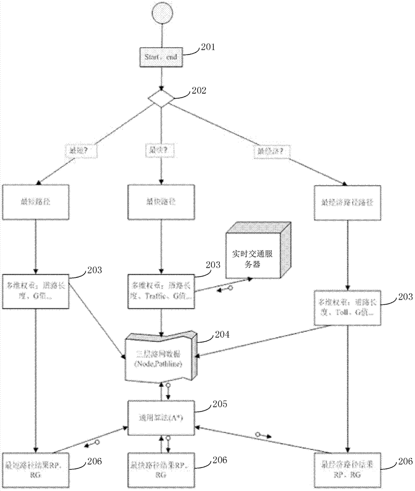
[0036] GIS (Geographic Information System, Geographic Information System) dynamic route planning is mainly based on real-time traffic and road condition information for dynamic route planning, and is mainly used for dynamic navigation of navigation instruments, PND (Portable Navigation Devices) and other equipment.

[0037] The present application proposes a dynamic path planning method, and the implementation process of the method described in the present application will be described in detail below through an embodiment.

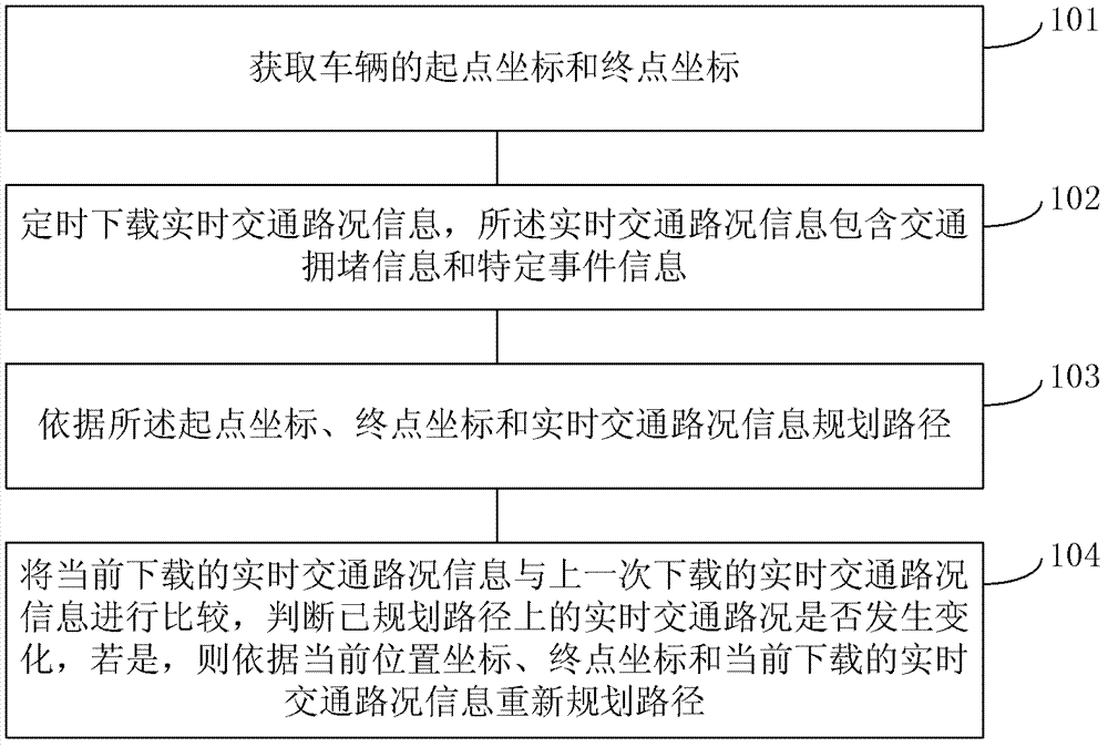
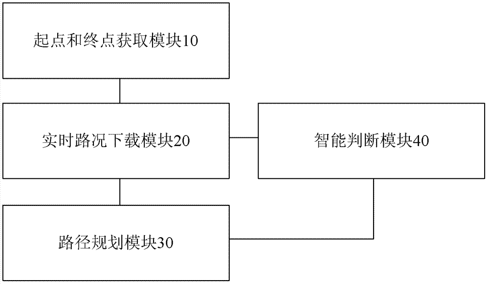
[0038] refer to figure 1 , is a flow chart of a vehicle route planning method described in the embodiment of the present application.

[0039] Step 101, obtaining the starting poin...


PUM


Abstract

The present invention provides a vehicle path planning method, a vehicle path planning system and a vehicle navigation apparatus so as to solve the problem of no real time traffic condition consideration of the static path planning method. The method comprises: acquiring a starting point coordinate and an end point coordinate of a vehicle; periodically downloading real-time traffic information, wherein the real-time traffic information comprises traffic congestion information and specific event information; and according to the starting point coordinate, the end point coordinate and a real-time traffic information planning path, comparing the currently downloaded real-time traffic information to the last downloaded real-time traffic information to determine whether the real-time traffic condition on the planned path is changed, wherein the path is re-planned according to the current position coordinate, the end point coordinate and the currently-downloaded real-time traffic information if the real-time traffic condition on the planned path is changed. With the present invention, traffic congestion roads can be dynamically evaded so as to provide the fastest driving path for a vehicle driver.

Description

technical field [0001] The present application relates to intelligent transportation technology, in particular to a vehicle route planning method and system and a vehicle navigation device. Background technique [0002] With the rapid development of global positioning system, geographic information system, electronic technology, and computer technology, vehicle navigation system is becoming one of the popular fields of comprehensive technology application, which can prevent traffic jams to the greatest extent and reduce the traffic jams of vehicles on the road. Stay time, and finally realize the optimal distribution of traffic flow on each road section in the network, so that the road network can be used most rationally and effectively. [0003] As the core part of the vehicle navigation system, route planning is required to be able to help vehicle drivers quickly and accurately plan the most optimal path. Therefore, the design and research of path planning methods in vehi...

Claims


Application Information

Patent Timeline
Patent Type & Authority Applications(China)
IPC IPC(8): G01C21/34G08G1/0968
Inventor 冯伟张志平张鹤高胡道生周双全夏曙东
Owner BEIJING TRANWISEWAY INFORMATION TECH
Why Eureka
Try Eureka