
Safety Assessment Method for Steep Slopes and Curved Roads

A safety assessment and road technology, applied in special data processing applications, instruments, electrical and digital data processing, etc., can solve the problems of inability to measure, large random errors and accumulated errors, and difficult to measure the geometric characteristics of mountain roads, so as to reduce traffic accidents, The effect of eliminating the influence of accumulated errors and improving the safe driving performance

Active Publication Date: 2015-08-19
XIAN FEISIDA AUTOMATION ENG
View PDF4 Cites 1 Cited by
  • Summary
  • Abstract
  • Description
  • Claims
  • Application Information

AI Technical Summary

Problems solved by technology

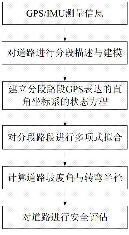
[0006] In order to overcome the technical defects of large random errors and cumulative errors in the existing road slope measurement methods and the inability to measure when data is missing, the present invention proposes a safety assessment method for steep slopes and curved roads. Segment description and segment fitting of road sections eliminate the influence of random errors in single-point measurement. When GPS records are not enough for smoothing or GPS records are missing, such as driving in a cave, combined with IMU measurement information, there are fewer GPS measurement records. Carry out spline interpolation and smoothing processing on the road section, get the fitting surface equation of the road, and then calculate the turning radius and slope of the road, and then use the recursive estimation to move the road forward section by section, and eliminate the accumulated error in the measurement by the limited memory method Improve the calculation accuracy of geometric parameters such as road slope and curvature, solve the technical problem that the geometric characteristics of existing mountain roads are difficult to measure, provide a basis for the traffic management department to monitor and inspect the road surface, and at the same time ensure the safe driving of vehicles on this road section Give load and speed requirements

Method used


Image

  • Safety Assessment Method for Steep Slopes and Curved Roads
  • Safety Assessment Method for Steep Slopes and Curved Roads
  • Safety Assessment Method for Steep Slopes and Curved Roads

Examples


Embodiment Construction

[0033] Refer to attached picture.

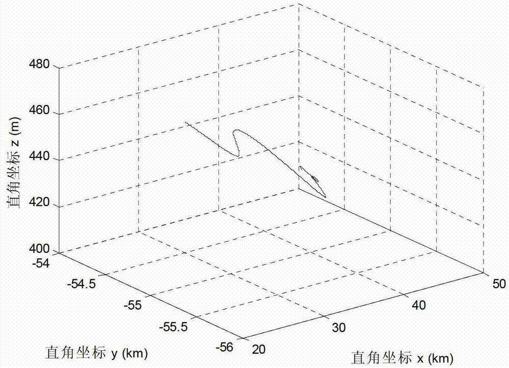
[0034] 1) Describe and model the road segmented according to the linear characteristics of the road: establish a geographic rectangular coordinate system with the initial point of measurement as the coordinate origin, and calibrate the coordinate axis direction of the established rectangular coordinate system so that it is consistent with the earth coordinates The direction of the system is consistent, and the measurement data recorded by the sensor is converted into the geographic Cartesian coordinate system relationship, draw the change trend diagram of the detected road section, see attached figure 2 , describe and model the road segment in the following way:

[0035]

[0036] In the formula, Represents the coordinates in the geographic Cartesian coordinate system with the initial point of measurement as the origin of the coordinates, as well as respectively The segment point location in the direction, is the number of divid...


PUM


Abstract

The invention discloses a safety evaluation method for a steep slope and a bending road, and is used for solving the technical problem that the random error and accumulated error are bigger and the road slope can't be measured when data is lost in the existing road slope measurement, and belongs to the field of road safety. The safety evaluation method for the steep slope and the bending road carries out section description and piecewise fitting for tested road sections according to the vehicle-mounted global position system (GPS) measurement information, combines inertial measurement unit (IMU) measurement information to carry out spline interpolation and smoothing processing for road sections with less GPS measurement records when the GPS records are insufficient to carry out the smooth processing or GPS records are lost as drivers drive in the cave, then get the fitting curved surface equation of the roads so as to calculate the turning radius and the slope of the roads. The safety evaluation method for the steep slope and the bending road then moves the roads ahead hop by hop by using recursive estimation, eliminates the influence of cumulative errors in measurement through the limited memory method, improves the calculation precision of geometrical parameters such as the road slope and the curvature, solves the technical problem that the existing roads are difficult to measure, provides the basis for the traffic management department to carry out road surface monitoring and acceptance inspection, and meanwhile proposes load and speed requirements for the safety traffic on the road section.

Description

technical field [0001] The invention relates to a road safety assessment method, in particular to a safety assessment method for dangerous sections of steep slopes and curved roads, belonging to the field of road driving safety. Background technique [0002] Curved roads with steep slopes are areas where traffic accidents frequently occur. The higher traffic accident rate is related to the road alignment of sharp turns and continuous turns, and the result of traffic accidents on curved roads is more serious than that on straight sections. In addition, continuous The traffic accident rate of the long uphill and downhill sections is significantly higher than that of the horizontal road surface. It can be seen that the unreasonable design of road geometric elements and the bad alignment combination are the direct causes of traffic accidents. The alignment characteristics of the actual road are analyzed Evaluation, combined with the characteristics of the road to limit the load ...

Claims


Application Information

Patent Timeline
Patent Type & Authority Patents(China)
IPC IPC(8): G06F19/00
Inventor 史忠科王慧丽
Owner XIAN FEISIDA AUTOMATION ENG
Learn More