Method for using handheld device to position plane area

A hand-held device and area positioning technology, which is applied in special data processing applications, image data processing, instruments, etc., can solve the problems of short recognition distance, limited scope of application, and inability to achieve positioning well, achieving low cost and convenient promotion and popularization, no need for equipment maintenance and disinfection effect

Inactive Publication Date: 2013-05-15
ZHEJIANG UNIV
View PDF1 Cites 17 Cited by
  • Summary
  • Abstract
  • Description
  • Claims
  • Application Information

AI Technical Summary

Problems solved by technology

[0017] The advantages of two-dimensional code positioning are simple principle, low cost and easy to popularize. The disadvantage is that the recognition distance is short, and not all places are suitable for pasting two-dimensional codes, and the scope of application is limited.
[0018] To sum up, the GPS method is only suitable for outdoor use and has low positioning accuracy. The AGPS and base station method is limited by the density and number of base stations and is mainly used outdoors. RFID positioning is not accurate enough and the scalability is not high. Two-dimensional code positioning Since pasting the two-dimensional code will destroy the two-dimensional plane itself and the interaction method is not direct and natural enough, none of the above positioning methods can well realize the positioning on the handheld device for the plane area.

Method used


Image

  • Method for using handheld device to position plane area

Examples


Embodiment Construction

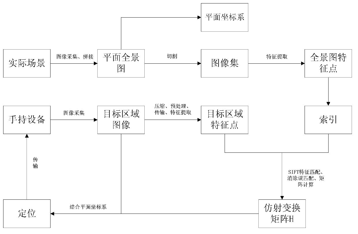
[0044] figure 1 It is a flow chart of the core algorithm of a planar area positioning method using a handheld device. The following is combined figure 1 And specific examples further illustrate the present invention.

[0045] (1) Acquisition of offline planar panoramas

[0046] For any actual scene with rich features, we need to use a high-precision camera to collect images, and through the method of image stitching, the collected image sequences are stitched into a complete planar panorama, which is used for the subsequent feature point extraction of the panorama and collection. For example, we take the big mural of Puxian Bodhisattva in the Three Grottoes of Yulin as an example. After collection and stitching, the size of the plane panorama is 15000×26250 pixels, and the size of a single picture is 216M.

[0047] (2) Establishment of offline plane coordinate system

[0048] According to actual needs, the upper left corner of the plane panorama is used as the origin, the ...


PUM


Abstract

The invention discloses a method of using a handheld device to position a plane area. The method comprises the following steps: obtaining corresponding panoramic view of a plane according to a real scene; erecting a plane coordinate system in the panoramic view of the plane; obtaining features of the panoramic view and corresponding coordinates under the plane coordinate system in the the panoramic view of the plane and erecting an index according to the features of the panoramic view; using the handheld device to collect images of a target area and uploading to a server; obtaining features of the imaged of the target area in the target area through the server, matching the features of the images of the target area with the features of the panoramic view, and erecting an affine transformation matrix H used for the coordinate transformation according to the matching relation; mapping the coordinates of the images of the target area to the panoramic view of the plane according to the affine transformation matrix by the server so as to achieve the positioning of the images of the target area in the real scene; and then passing back the corresponding positioning information to the handheld device. The method of using the handheld device to position the plane area is convenient and fast, real-time, efficient and accurate.

Description

technical field [0001] The invention relates to wireless positioning and image matching technology on a hand-held device, in particular to a planar area positioning method using a hand-held device. Background technique [0002] In the information age, people's demand for personalized, intelligent and precise positioning continues to increase. At the same time, the hardware of handheld devices has been greatly developed. According to the statistics of Flurry, an American mobile communication market analysis company, China has become the second largest mobile phone application market in the world. Chinese mobile phone users have reached 952 million, of which the smartphone market has reached 25.0%. [0003] With the development of handheld device hardware and the popularization of wireless network environments, the positioning technology on handheld devices has made great progress and development. How to naturally and efficiently perform personalized, intelligent and accurate...

Claims


Application Information

Patent Timeline
Patent Type & Authority Applications(China)
IPC IPC(8): G06F17/30G06T7/00
Inventor 鲁东明刘昱杰赵磊郑斌
Owner ZHEJIANG UNIV
Why Eureka
Try Eureka