
Temporal geographic information system (GIS) data management and presentation method

A technology of data management and spatio-temporal data, applied in the direction of electrical digital data processing, special data processing applications, instruments, etc., can solve the problems of low efficiency of historical retrospective, ignoring the evolution process of individual space objects, etc.

Inactive Publication Date: 2013-06-12
NANJING GUOTU INFORMATION IND
View PDF2 Cites 16 Cited by
  • Summary
  • Abstract
  • Description
  • Claims
  • Application Information

AI Technical Summary

Problems solved by technology

[0003] The ground state modified spatio-temporal data model can improve temporal resolution and reduce data redundancy, but in the case of frequent historical dynamic changes, it highlights the disadvantage of low efficiency of historical retrospective[5]
At present, the improvement of the ground state modified spatio-temporal data model focuses on solving the data storage and retrieval problem at a certain moment relative to the ground state within the entire region [1-5], ignoring the evolution process of individual spatial objects

Method used


Image

  • Temporal geographic information system (GIS) data management and presentation method

Examples


Embodiment Construction

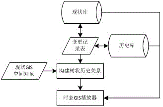
[0025] The specific implementation manners of the present invention will be further described in detail below in conjunction with the accompanying drawings. Such as figure 1 The process shown is carried out, and the change relationship of the spatial object is recorded through the change record table, and the current database and the historical database are connected. The operation method of the history traceback of a single space object is to obtain the current space object that needs to be queried first, and then backtrack to obtain the space object in its initial state, take the initial state space object as the root node, and recursively build the data related to the initial state space object through preorder traversal. All sub-nodes establish a tree-like historical relationship for the backtracking of a single spatial object.

[0026] The acquisition of the initial state space object is based on the status number of the historical relationship that needs to be traced ba...


PUM


Abstract

The invention relates to a temporal geographic information system (GIS) data management and presentation method. The temporal GIS data management and presentation method comprises the following steps: (1) storing temporal GIS data by an improved base state modified spatio-temporal data model; (2) recording the change relationship of a GIS space object by a change record sheet; (3) inquiring the change record sheet by an algorithm and establishing the tree history relationship; and (4) demonstrating the evolution relationship of the GIS space object by the representation mode of a temporal GIS player. By the temporal GIS data management and presentation method, the problems about the history relationship retrieval efficiency and presentation of the GIS space data under the condition of frequent dynamic change are solved.

Description

technical field [0001] The invention relates to the whole life cycle management and historical relationship display of GIS spatial objects based on the improved ground state modified spatio-temporal data model, which describes the temporal change process of GIS spatial objects in the form of animation, and visually displays its historical evolution relationship, which is suitable for time Dynamic GIS data management and presentation. Background technique [0002] With the continuous expansion of GIS application fields and the continuous increase of human needs, temporal GIS has attracted more and more attention from the industry[1]. : Sequence snapshot model, ground state modified spatio-temporal data model, spatio-temporal composite model, non-first normal form spatio-temporal data model, event-based spatio-temporal data model, etc. [2]. Among them, the ground state modified spatio-temporal data model is characterized by sampling at a preset time interval, and only storing...

Claims


Application Information

Patent Timeline
Patent Type & Authority Applications(China)
IPC IPC(8): G06F17/30
Inventor 王履华孙在宏吴长彬吉波狄晓涛高权忠
Owner NANJING GUOTU INFORMATION IND
Learn More