
An Evaluation Method for Geographic Data Watermarking Algorithm

A technology of geographic data watermarking and geographic data, which is applied in image data processing, image data processing, computing and other directions, and can solve problems such as geographic data requirements, inability to find watermarked data errors, and navigation errors.

Active Publication Date: 2015-12-23
WUHAN UNIV
View PDF3 Cites 0 Cited by
  • Summary
  • Abstract
  • Description
  • Claims
  • Application Information

AI Technical Summary

Problems solved by technology

However, geographic data has strict requirements on accuracy. The human visual system cannot detect errors caused by watermarked data, but computers can easily detect such errors and cause navigation errors.

Method used


Image

  • An Evaluation Method for Geographic Data Watermarking Algorithm
  • An Evaluation Method for Geographic Data Watermarking Algorithm
  • An Evaluation Method for Geographic Data Watermarking Algorithm

Examples


Embodiment

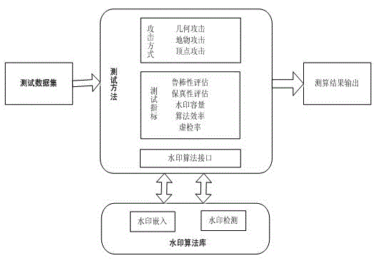
[0079] An evaluation method suitable for geographic data watermarking algorithms, the method mainly starts from several evaluation indicators such as robustness, fidelity, watermark capacity, and running speed.

[0080] Define the benchmark dataset D={M 1 , M 1 ,...,M m} represents m geographic datasets; for each geographic dataset M k ={R k ,P k}, where R k Indicates the reference coordinate system, Represents a collection of various types of features, n is the number of features; each feature It consists of a series of vertices, l is the number of vertices of feature i in the kth data set, k∈{1,2,…,m}, i∈{1,2,…,n}.

[0081] The specific operation steps are as follows:

[0082] Step 1. Select the data set for the benchmark test, and use the watermarking algorithm to be tested to embed the watermark into the geographic data;

[0083] Step 2, quantitatively measure the fidelity of the geographic data after the watermark is embedded, and obtain a quantitative value ba...


PUM


Abstract

The invention discloses an evaluating method for a geographic data watermarking algorithm. The evaluating method includes the steps: firstly, selecting various geographic data with various purposes, multiple scales, different data volumes and different accuracy as a reference data set; secondly, defining a robustness evaluation method for anti-attack degree according to the integral area of a watermarking accuracy-attack amplitude curve; and finally, quantitatively evaluating the fidelity performance of data before and after embedding watermarks in terms of accuracy, the topological relation between ground objects and shape. Indexes also include watermarking capacity and operation speed, and a testing scheme is realized by comprehensively set evaluation indexes, so that the method can fairly and reasonably evaluate the watermarking algorithm under the same condition.

Description

technical field [0001] The invention relates to a watermark evaluation method, in particular to an evaluation method for geographic data watermark algorithms. Background technique [0002] With the development of information technology, geographic information system (GIS) plays an increasingly important role in economic development. At present, GIS technology is widely used in vehicle navigation, online map and military command. Geographical data is the foundation of GIS applications, but geographic data collection costs are high, and production and management are a complex project that consumes a lot of financial and material resources. Therefore, geographic data is a valuable asset for data producers. However, the copying of geographic data is very easy. Once the geographic data is sold, illegal copying is unavoidable, which damages the interests of data owners. [0003] As an effective copyright protection technology, digital watermarking embeds watermark information wi...

Claims


Application Information

Patent Timeline
Patent Type & Authority Patents(China)
IPC IPC(8): G06T1/00
Inventor 彭智勇岳名亮李晓梅彭煜玮
Owner WUHAN UNIV
Learn More