Road network shape point data loading method and device, and navigation method and device

A loading device and shape point technology, applied in the navigation field, can solve problems such as large amount of calculation, affecting user navigation experience, and heavy load of the navigation system, so as to speed up the loading speed and improve the performance of loading and use

Active Publication Date: 2013-07-03
SHANGHAI PATEO ELECTRONIC EQUIPMENT MANUFACTURING CO LTD
View PDF9 Cites 8 Cited by
  • Summary
  • Abstract
  • Description
  • Claims
  • Application Information

AI Technical Summary

Problems solved by technology

[0005] However, when drawing a path on the electronic map, it is often necessary to draw many shape points. During navigation, especially when previewing the route, for example, the navigation path from Beijing to Shanghai is displayed on the navigation electronic map. At th

Method used


Image

  • Road network shape point data loading method and device, and navigation method and device
  • Road network shape point data loading method and device, and navigation method and device
  • Road network shape point data loading method and device, and navigation method and device

Examples


Example Embodiment

[0047] Example one

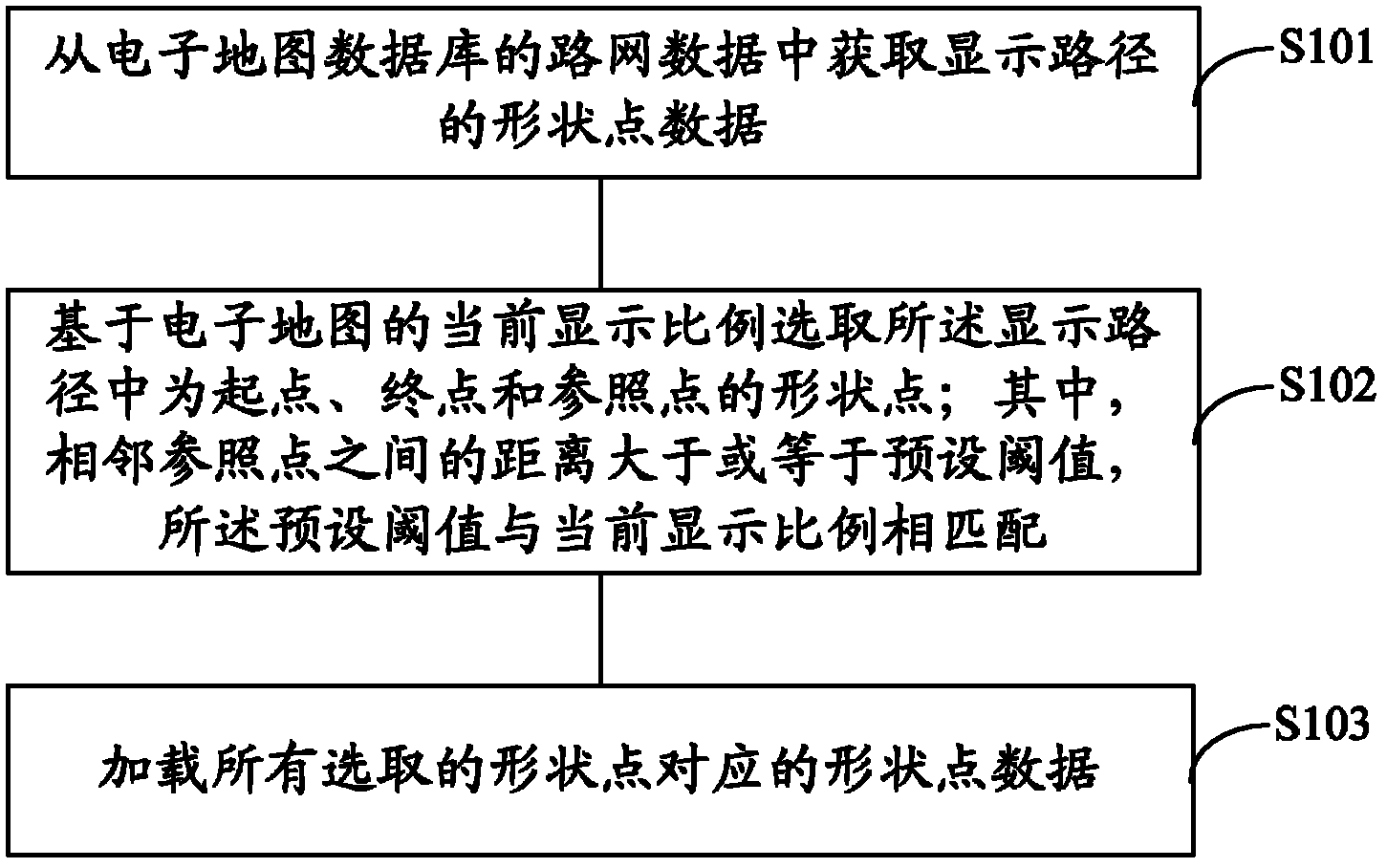
[0048] In this embodiment, the loading of shape point data of the navigation path in the car navigation system is taken as an example for description. The electronic map is specifically a navigation electronic map, and the displayed path is specifically a navigation path obtained after path calculation based on a navigation request. . In other embodiments, the electronic map may also be map software provided by other terminal devices, such as map software running in terminal devices such as mobile phones, computers, handheld multimedia players, etc., and it may not necessarily be based on navigation requirements. It only queries the path from one location to another, and displays the path on the display screen of the terminal device.

[0049] When a user needs a navigation service, by triggering a navigation request, after receiving the navigation request, the car navigation system performs path calculation based on the navigation request (including the inform...

Example Embodiment

[0074] Example two

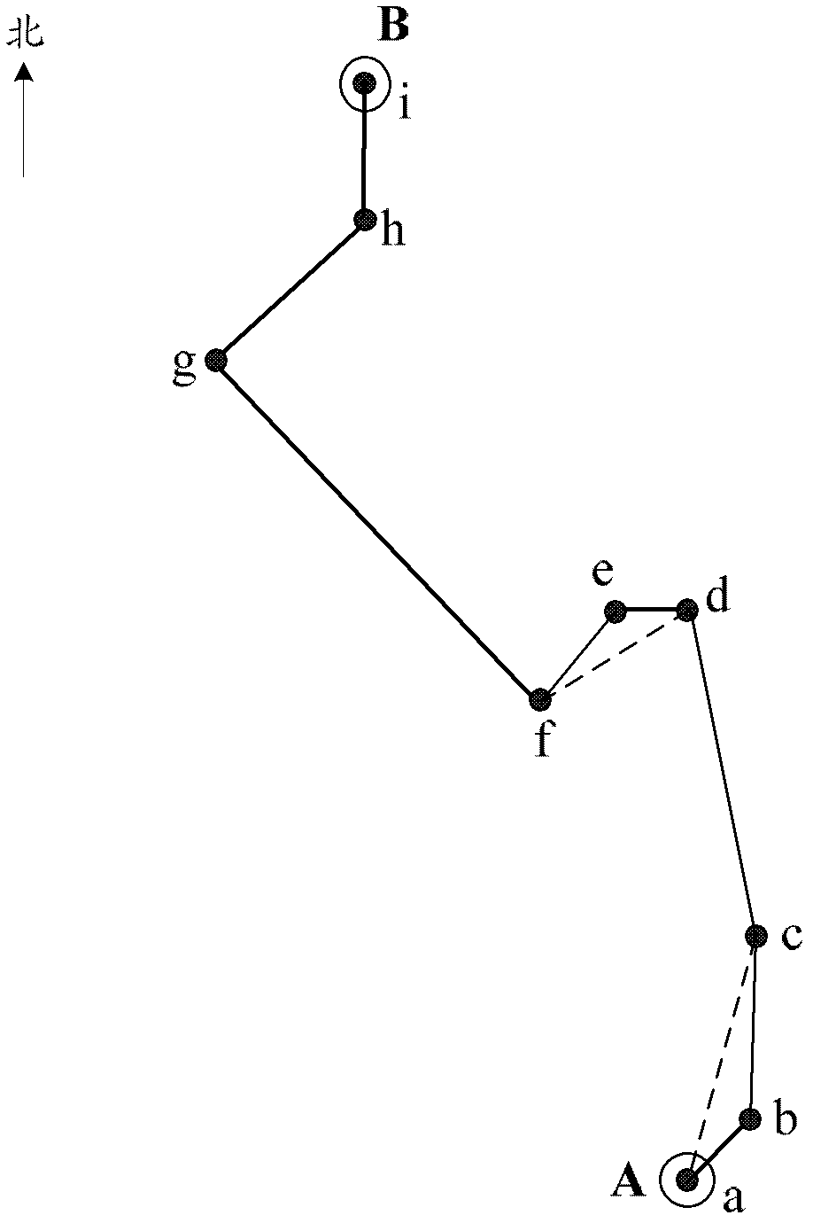
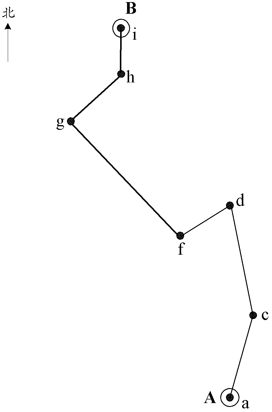
[0075] In the first embodiment, according to the different display scales of the electronic map, the corresponding road network shape point data is extracted to improve the performance of loading and using the shape point data. However, since the path is displayed on the electronic map, in order to see clearly For the details of a local road section or to understand the location of the path in a large range, the display scale needs to be adjusted. At this time, it is necessary to extract the shape points of the displayed path according to the adjusted display scale, and then load the analysis The shape point data corresponding to the shape point obtained later requires a certain amount of calculation time due to the extraction process, which will cause a delay when the user switches the display scale, which affects the user experience. For this reason, the inventor considers that when the displayed path is obtained, the shape points of the displayed path can ...


PUM


Abstract

The invention provides a road network shape point data loading method and device, and a navigation method and device. The road network shape point data loading method comprises: obtaining shape point data of display road from road network data in an electronic map database; and selecting shape points of a start point, an end point and a reference point in the display path based on a current display proportion of an electronic map. Wherein, distance between adjacent reference points is larger than or equal to a preset threshold, and the preset threshold is matched to the current display proportion; shape points relative to all selected shape points are loaded. The technical scheme of the invention, based on the different display proportion of the electronic map, abstracts the relative road network shape point data, to raise the loading and using performances of the shape point data.

Description

technical field [0001] The invention relates to the technical field of navigation, in particular to a method and device for loading road network shape point data, and a navigation method and device. Background technique [0002] With the development of the automobile industry, people pay more and more attention to the user experience when using a car while owning a car. Existing in-vehicle devices can already provide users with many services, including services for multimedia needs such as music, video, and pictures, as well as driving navigation services such as real-time traffic information and destination maps. In particular, the use of vehicle navigation systems is becoming more and more popular. The voice prompts of the navigation system can guide the user to drive, especially when driving in an unfamiliar city, the navigation system can help the user to reach the destination conveniently and quickly. [0003] For the land moving target navigation system, the navigatio...

Claims


Application Information

Patent Timeline
IPC IPC(8): G01C21/26G09B29/00
Inventor 王军
Owner SHANGHAI PATEO ELECTRONIC EQUIPMENT MANUFACTURING CO LTD
Why Eureka
Try Eureka