Indoor map and making method thereof

A technology of indoor maps and production methods, which is applied in the field of indoor maps, can solve problems such as unproduction methods and process research, and achieve avoiding excessive map load, accurate positioning information and occupancy information, spatial orientation relationship and spatial topology The effect of a clear relationship

Inactive Publication Date: 2013-10-02
WUHAN UNIV
View PDF10 Cites 24 Cited by
  • Summary
  • Abstract
  • Description
  • Claims
  • Application Information

AI Technical Summary

Problems solved by technology

[0007] Aiming at the problem of indoor map drawing, there is no corresponding research result in China at present, and there are some academic literatures abroad, mainly including: "The design of a handheld, location-aware guide for indoor environments" (Ciavarella et al., "Personal and ubiquitous computing"), "You-are-here maps in emergencies——the danger of getting lost" (Klippel e

Method used


Image

  • Indoor map and making method thereof
  • Indoor map and making method thereof
  • Indoor map and making method thereof

Examples


Embodiment Construction

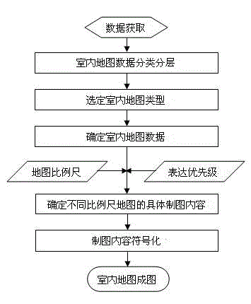
[0031] The technical solutions of the present invention will be described below in conjunction with the drawings and embodiments.

[0032] An indoor map making method provided by the embodiment mainly includes the following contents:

[0033] (1) Classification and stratification of indoor data;

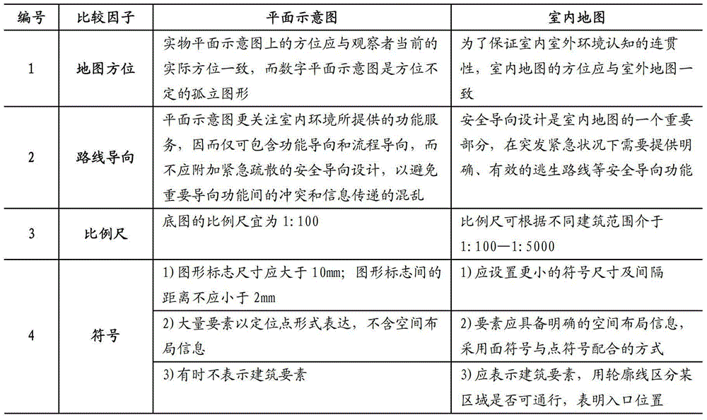
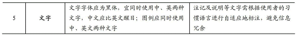
[0034] During specific implementation, objects can be classified according to characteristics such as properties and functions, and those skilled in the art can pre-set the classification rules by themselves. The embodiment provides a more scientific and reasonable division method for reference: divide the indoor data into seven types of elements: architectural elements, connection elements, traffic elements, security elements, convenience facilities, functional areas and annotations. Each feature class is further divided into several feature layers, and the division of each feature class and its feature layers is shown in Table 2.

[0035] Among them, "main building outline" indic...


PUM


Abstract

The invention relates to an indoor map and a making method thereof. The making method comprises the steps of acquiring and obtaining cartographic data of a cartographic area, classifying and layering the cartographic data, further dividing each feature class into a plurality of feature layers, determining an adopted indoor map type, namely an indoor layout map, an indoor route map or an indoor escape map, determining map data of the cartographic area according to the feature layer corresponding to the selected indoor map type, expressing priority according to the feature layers in the map data, determining specific cartographic contents of the maps in different scales, and generating and outputting the indoor map according to the determined specific map contents. According to the indoor map and the making method thereof, the indoor data is classified and layered, so that the method is applicable to various indoor environments; carrying capacities of the maps in different scales are considered; expression priorities are set for indoor data layers; the corresponding map contents are displayed according to different map scales; the requirement of a user on map cognition is met; and the map can better serve for indoor and outdoor navigation.

Description

technical field [0001] The invention relates to a method for classifying indoor map data, the map data of which is beneficial to GIS data management and analysis, and relates to a method for making an indoor map and the indoor map obtained by the method to serve indoor navigation. Background technique [0002] Nowadays, indoor and outdoor navigation is a hot research field. Outdoor navigation is supported by various mature maps, while indoor navigation uses planar diagrams as its map basis. Plane schematic diagrams are usually physical graphics fixed on the interior walls of buildings, etc., facing all kinds of people entering and leaving the place and taking into account the needs of different aspects as much as possible. The production method is based on "GB / T20501.3-2006 Public Information Guidance System Design Principles and Requirements for Elements Part 3: Floor Plans and Information Boards. The plane diagram has no clear data classification and layering, and each da...

Claims


Application Information

Patent Timeline
IPC IPC(8): G09B29/00
Inventor 李霖郭云嫣朱海红应申蒯希谭永滨
Owner WUHAN UNIV
Why Eureka
Try Eureka