
Remote sensing image acquisition method of UAV with variable altitude in the same sortie

A UAV, aerial height technology, applied in surveying and navigation, altitude or depth control, photogrammetry/video surveying and other directions, can solve problems such as equipment loss, accident increase, operation trouble, etc. Consistent, good ground resolution, good consistency

Active Publication Date: 2016-01-20
CHONGQING SURVEY INST
View PDF4 Cites 0 Cited by
  • Summary
  • Abstract
  • Description
  • Claims
  • Application Information

AI Technical Summary

Problems solved by technology

[0004] For mountainous areas, due to the large terrain fluctuations, the relative height between the UAV and the ground is in a dynamic state, and the relative height is an important factor affecting the image resolution. During aerial photography, the ground resolution of aerial photography images is uneven, sometimes good and sometimes bad, which not only increases the difficulty of image matching in the office, but also requires more driving times to ensure the consistency of ground resolution Frequent take-off and landing of UAVs to perform repeated shooting operations at different heights in the same area, the operation is cumbersome, the equipment wears out seriously, and with the increase in the number of take-offs, the probability of accidents also increases relatively

Method used


Image

  • Remote sensing image acquisition method of UAV with variable altitude in the same sortie
  • Remote sensing image acquisition method of UAV with variable altitude in the same sortie
  • Remote sensing image acquisition method of UAV with variable altitude in the same sortie

Examples


Embodiment Construction

[0031] A control method for the same sortie variable flight height in aerial photography of UAVs, including UAVs, UAV flight height control modules, and aerial photography equipment mounted on UAVs. The innovation lies in: setting the aerial photography The lens focal length of the device is f, the pixel size is a, and both f and a are known quantities; during a single flight of a UAV, adjust the flight height of the UAV as follows:

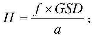
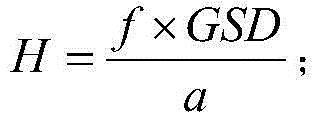
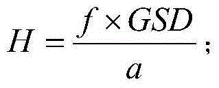
[0032] 1) The theoretical ground resolution GSD is preset in the UAV flight height control module. When just taking off, the UAV flight height control module calculates the theoretical relative height H between the UAV and the ground according to the formula, and adjusts it according to H The initial flying height of the drone:

[0033] H = f × GSD a ;

[0034] After reaching the initial flight altitude and reaching the predet...


PUM


Abstract

Provided is a method for obtaining remote-sensing images by a same-sortie variable-flight-height unmanned aerial vehicle. The method comprises an unmanned aerial vehicle body, an unmanned aerial vehicle flight height control module and aerial photography equipment carried by the unmanned aerial vehicle body. The method is characterized in that in the flying process of the unmanned aerial vehicle, the flight height of the unmanned aerial vehicle is dynamically adjusted according to changes of heights of terrains. The method has the advantages that under the condition that the take-off and landing times are reduced, the situation that the ground resolution of the images is in a good state is effectively guaranteed, meanwhile, consistency of the ground resolution of the different images is good, and processing difficulty of the images in the later period is reduced.

Description

technical field [0001] The invention relates to a technology for aerial photography by using a UAV, in particular to a method for acquiring remote sensing images of an UAV with the same sortie and variable altitude. Background technique [0002] Surveying and mapping, as a preliminary and basic work in social development and economic construction, has very important practical significance for urban and rural overall planning and new rural construction in mountainous areas; UAV technology is an emerging technology that has emerged in recent years , compared with previous aerial photography methods, the use of drones for aerial photography has the advantages of low cost and convenient operation; [0003] In the existing technology, UAV technology has been applied in surveying and mapping operations, but the current application environment is limited to the acquisition of remote sensing images in plain areas. Under the circumstances, when the UAV is taking aerial photography o...

Claims


Application Information

Patent Timeline
Patent Type & Authority Patents(China)
IPC IPC(8): G05D1/04G01C11/00
Inventor 向泽君梁建国胡开全张俊前周智勇王快马红严以成骆亮陈银福刘超祥王昌翰王莉
Owner CHONGQING SURVEY INST
Learn More