
An Aerial Dynamic Acquisition System of Large-Scale Vegetation Coverage

A technology of vegetation coverage and acquisition system, which is applied in the field of large-scale vegetation coverage aerodynamic acquisition system, and can solve problems such as poor spatiotemporal portability, poor model portability, and a large amount of measured data.

Inactive Publication Date: 2015-08-12
CHINA INST OF WATER RESOURCES & HYDROPOWER RES
View PDF5 Cites 2 Cited by
  • Summary
  • Abstract
  • Description
  • Claims
  • Application Information

AI Technical Summary

Problems solved by technology

Among them, the empirical model is mainly suitable for the research area with relatively consistent vegetation growth. For example, the monitoring of large-scale crop vegetation coverage requires obtaining a large number of vegetation growth environmental elements and spatio-temporal elements on the basis of obtaining ground vegetation coverage data. The portability of the established model is poor; remote sensing technology provides the possibility for large-scale coverage measurement with inconsistent vegetation growth conditions on the ground. Using spectral information and ground vegetation coverage to establish a model relationship to obtain large-area ground vegetation coverage, this method can be roughly divided. It is a statistical model method and a physical model method. The former is simple and easy to calculate, but requires a large amount of measured data and has poor temporal and spatial transferability. The latter uses the characteristics of vegetation spectral information to select a vegetation index that has a good correlation with vegetation coverage to estimate vegetation. Coverage, good universality, but poor ability to eliminate the influence of background information, and relatively low accuracy; pixel decomposition model method requires high spatial resolution of remote sensing data, which limits the promotion of the method
It can be seen that the above three methods have their own advantages and disadvantages, and all of them can be used to extract macroscopic vegetation coverage information in a large area with high work efficiency. Data availability and effectiveness cannot be guaranteed

Method used


Image

  • An Aerial Dynamic Acquisition System of Large-Scale Vegetation Coverage

Examples


Embodiment Construction

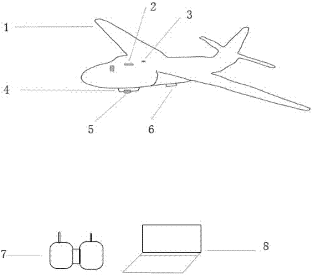
[0022] See figure 1 , The present invention is an aerial dynamic acquisition system (VC-ADAD) of vegetation coverage, which is composed of two main parts: hardware and software. The hardware mainly includes: UAV platform 1, automatic navigator 2, GPS receiver 3, aerial photography fixture 4, digital aerial photography instrument 5, wireless digital image transmission system 6, navigation controller 7 and notebook computer 8. The position connection relationship between them is: automatic navigator 2, GPS receiver 3, aerial photography fixed device 4, wireless digital image transmission system 6 are installed on UAV platform 1, and digital aerial photography instrument 5 is installed on aerial photography fixed On the device 4; the navigation controller 7 is placed on the ground and operated by the drone operator; the notebook computer 8 is placed on the ground, and the aerial photography task flight management and control system and the vegetation coverage dynamic acquisition ...


PUM


Abstract

The invention discloses an aerial dynamic large-scale vegetation coverage acquisition system which consists of an unmanned plane platform, a GPS (global positioning system) receiver, an automatic navigator, an aerial photography fixing device, a digital aerial photographic camera, a wireless digital image transmission system, a navigation controller, notebook computer hardware and two pieces of software, namely an aerial photography task flying management and control system and a dynamic vegetation coverage acquisition system, wherein the digital aerial photographic camera is arranged on the aerial photography fixing device of the unmanned plane platform; the aerial photography fixing device, the GPS receiver, the automatic navigator and the wireless digital image transmission system are arranged on the unmanned plane platform; the two pieces of software are arranged in a notebook computer; an unmanned plane flies with the assistance of the automatic navigator; the flying and the landing of the unmanned plane are guided and adjusted through the navigation controller; a user observes images shot by the digital aerial photographic camera and captures images through the wireless digital image transmission system and the dynamic vegetation coverage acquisition system, and then vegetation coverage information can be overall and directly calculated.

Description

technical field [0001] The present invention is a large-scale vegetation coverage aviation dynamic acquisition system (LSVC-ADAD) used in water conservancy and water and soil conservation monitoring business, which is used in the field to conduct dynamic observation of land cover in a large area, especially in areas that are difficult for workers to reach , taking pictures, combined with the Vegetation Coverage Dynamic Acquisition System (VC-DAS) to directly measure large-scale vegetation coverage information in real time, dynamically, and in batches, which belongs to the technical application field of the water conservancy industry. Background technique [0002] Vegetation coverage refers to the ratio of the vertical projection area of ​​the canopy, branches and leaves of all vegetation, including trees, shrubs, grasses and crops, to the area of ​​the research statistical area. As an important indicator of vegetation coverage, vegetation coverage is the basic data that wate...

Claims


Application Information

Patent Timeline
Patent Type & Authority Patents(China)
IPC IPC(8): G01C11/02B64C39/02G08C17/02G01C21/20
Inventor 路京选庞治国宋文龙付俊娥李青曹大岭曲伟
Owner CHINA INST OF WATER RESOURCES & HYDROPOWER RES
Learn More