Eureka AIR delivers breakthrough ideas for toughest innovation challenges, trusted by R&D personnel around the world.

Quick drought index monitoring method based on land surface temperature and vegetation index feature space

A technology of surface temperature and vegetation index, applied in the field of drought inversion of satellite remote sensing data, can solve the problems of unstable wet and dry edges, excessive amplification of variable differences, etc., and achieve the effect of clarifying biophysical significance

Inactive Publication Date: 2014-03-26
INST OF REMOTE SENSING & DIGITAL EARTH CHINESE ACADEMY OF SCI
View PDF3 Cites 23 Cited by
  • Summary
  • Abstract
  • Description
  • Claims
  • Application Information

AI Technical Summary

Problems solved by technology

[0006] In view of the problems existing in the prior art, the purpose of the present invention is to provide a method for quickly determining the drought index based on the feature space of surface temperature and vegetation index, which solves the problem of unstable dry and wet edges in the previous feature space method, and excessively magnifies the difference in variables. Even the value of the obtained parameter exceeds the value range of the parameter's physical meaning.

Method used


Image

  • Quick drought index monitoring method based on land surface temperature and vegetation index feature space
  • Quick drought index monitoring method based on land surface temperature and vegetation index feature space
  • Quick drought index monitoring method based on land surface temperature and vegetation index feature space

Examples


Embodiment Construction

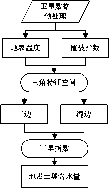
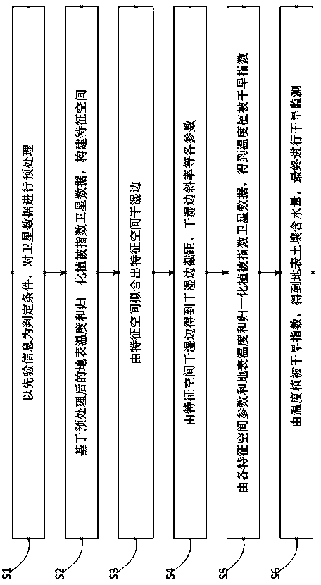
[0032] Below, refer to the attached figure 1 , figure 2 , the present invention will be described more fully, and exemplary embodiments of the present invention are shown in the accompanying drawings. This invention may, however, be embodied in many different forms and should not be construed as limited to the exemplary embodiments set forth herein. Rather, these embodiments are provided so that this disclosure will be thorough and complete, and will fully convey the scope of the invention to those skilled in the art.

[0033] The monitoring method of the present invention utilizes MODIS L2 data to construct a feature space with the preprocessed normalized difference vegetation index satellite data as the horizontal axis and the preprocessed surface temperature as the vertical axis. A feature space method normalization coefficient is proposed, and the normalization coefficient is set as a variable, which is substituted into the calculation expression of temperature vegetati...


PUM


Abstract

The invention discloses a quick drought index monitoring method based on a land surface temperature and vegetation index feature space. The method specifically comprises the following steps: remotely sensing land surface temperature and vegetation index of a monitored area by utilizing a satellite; taking prior information as a determination condition, and preprocessing the data of the satellite; constructing a feature space based on the preprocessed land surface temperature and normalized vegetation index satellite data; fitting out wet sides and dry sides of the feature space by the feature space; obtaining the intercept of the wet sides and the dry sides, the slopes of the wet sides and the dry sides and the like by the wet sides and the dry sides of the feature space; obtaining a temperature vegetation drought index according to each feature space parameter, the land surface temperature and the normalized vegetation index satellite data; obtaining the water content of land surface soil according to the temperature vegetation drought index, and finally performing drought monitoring. According to the method, the problems that the dry sides and the wet sides in the conventional feature space method are instable, variable difference is magnified excessively, and even an error phenomenon that the numerical values of the obtained parameters exceed the due physical meaning range of the parameters appears are solved.

Description

technical field [0001] The invention relates to the field of drought inversion of satellite remote sensing data, in particular to a rapid monitoring method for drought index based on surface temperature and vegetation index feature space. Background technique [0002] Drought has caused huge losses to human society, especially agricultural production. Among the losses caused by various natural disasters in China, drought ranks first. According to statistics, nearly 60% of China's agricultural natural disasters are caused by drought. Therefore, the study of drought monitoring is of great significance for understanding the degree and distribution of drought, taking effective measures for drought prevention and drought relief, and scientifically guiding agricultural production. [0003] However, the traditional drought monitoring method is mainly based on the determination of soil moisture content based on limited drought measurement stations for drought monitoring. The samp...

Claims


Application Information

Patent Timeline
IPC IPC(8): G01N33/24
Inventor 顾坚斌陈良富陶金花苏林范萌邹铭敏
Owner INST OF REMOTE SENSING & DIGITAL EARTH CHINESE ACADEMY OF SCI
Why Eureka
Eureka Blog
Learn More