Multi-source data fusion and environmental pollution source and pollutant distribution analysis method

A pollutant distribution and multi-source data technology, applied in the field of multi-source data fusion and analysis of environmental pollution sources and pollutant distribution, can solve problems affecting climate change, visibility reduction, etc., to achieve improved inversion accuracy, high time resolution, The effect of high spatial resolution

Inactive Publication Date: 2019-08-30
河北中科遥感信息技术有限公司
View PDF0 Cites 35 Cited by
  • Summary
  • Abstract
  • Description
  • Claims
  • Application Information

AI Technical Summary

Problems solved by technology

Compared with particulate matter such as TSP and PM10, PM2.5 is easy to attach toxic and harmful substances such as heavy metals and microorganisms due to its small particle diameter, and can pass through the nasal cavity and respiratory tract to reach the alveolar area of ​​the human body, which has a greater impact on human health. ; It has a strong extinction of visible light, and when it is high in concentration, the visibility will decrease sharply, causing traffic accidents, highway closures and flight delays; the scattering and absorption of solar radiation will also affect climate change

Method used


Image

  • Multi-source data fusion and environmental pollution source and pollutant distribution analysis method
  • Multi-source data fusion and environmental pollution source and pollutant distribution analysis method
  • Multi-source data fusion and environmental pollution source and pollutant distribution analysis method

Examples


Embodiment 1

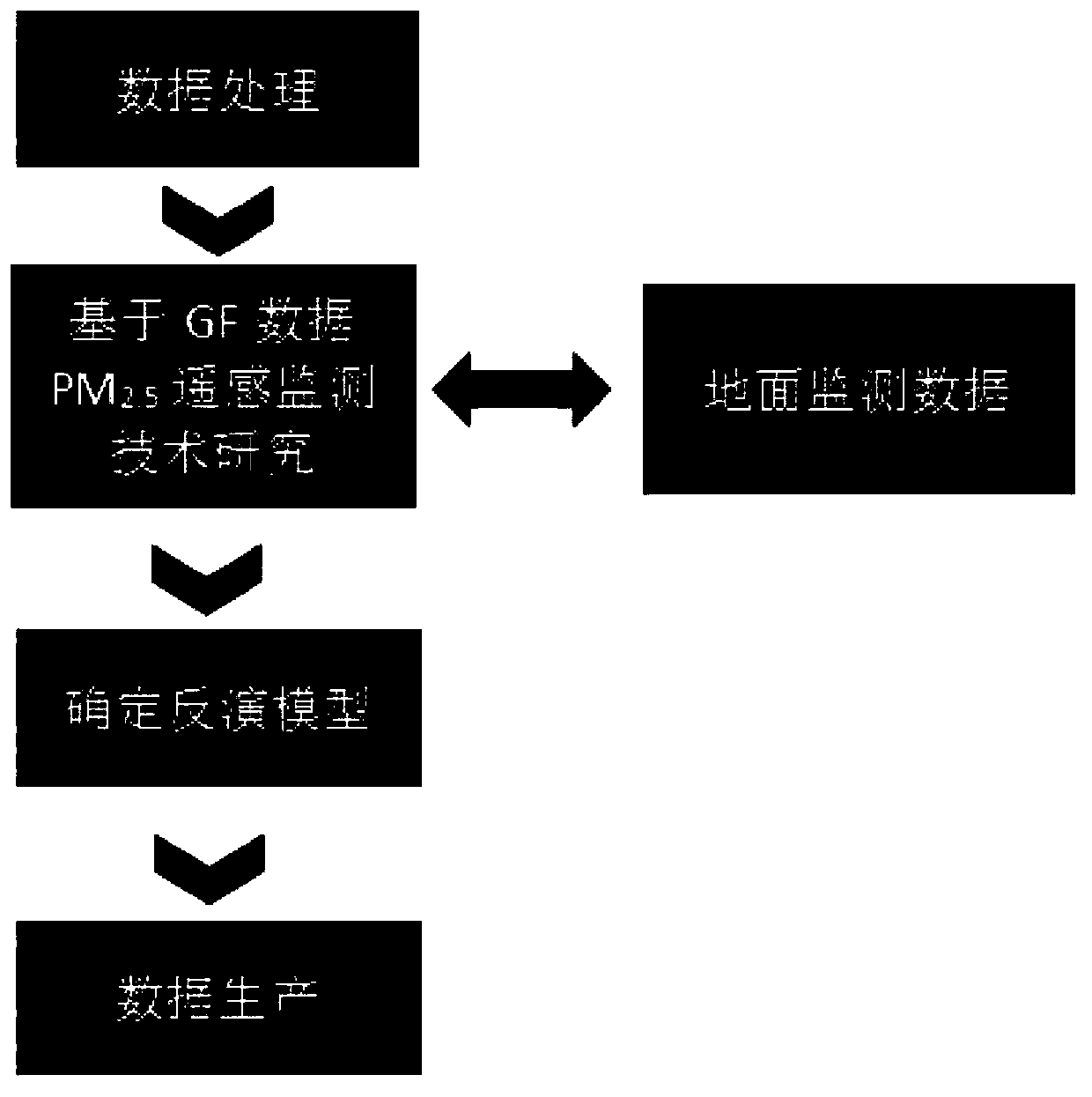
[0054] Multi-source data fusion and environmental pollution sources and pollutant distribution analysis methods, which are mainly composed of data preprocessing, aerosol inversion, and PM2.5 inversion;

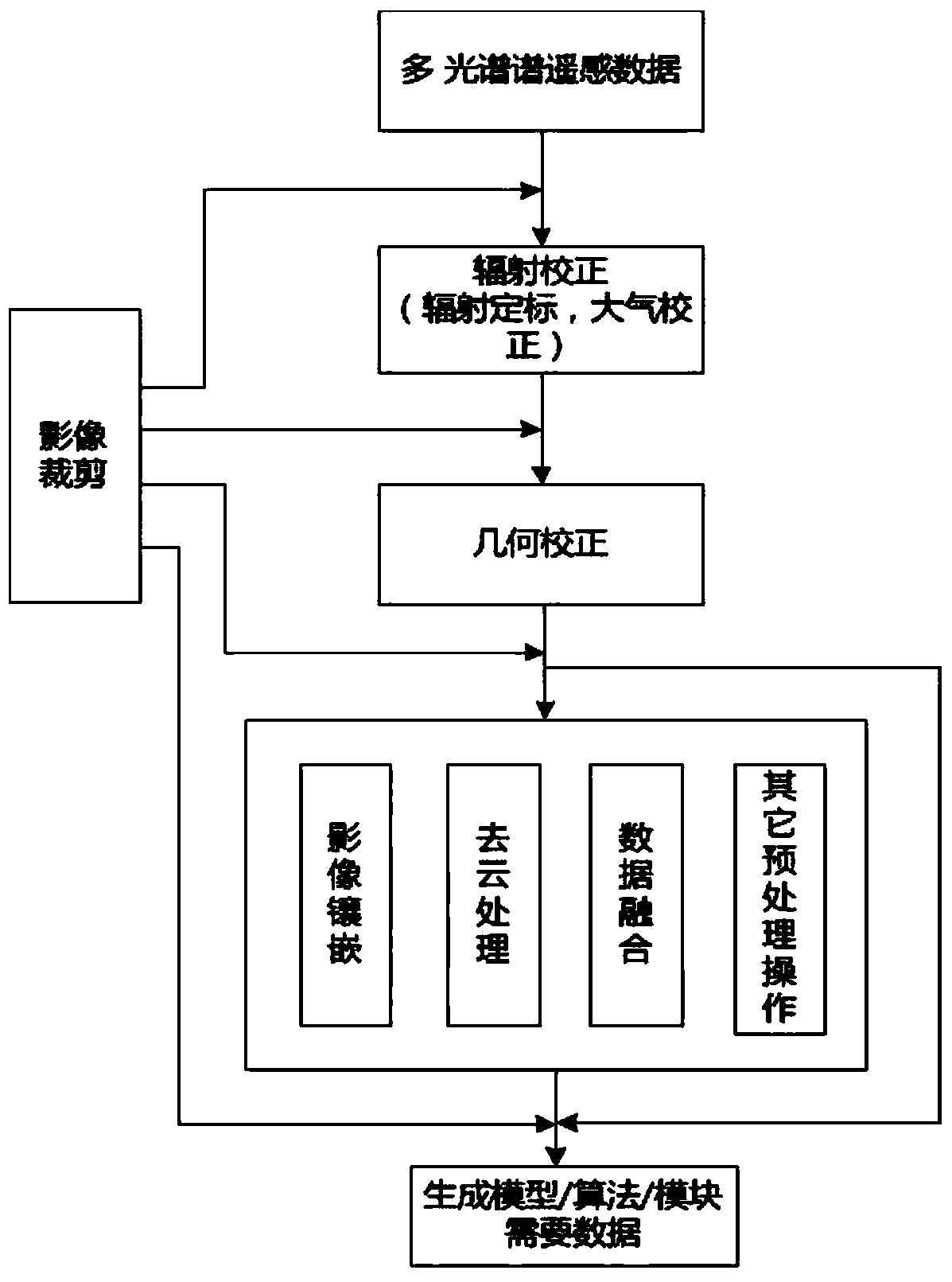
[0055] The data preprocessing performs a series of processing on the original remote sensing data, and outputs the data that meets the requirements of the model operation as the data basis of the inversion module. The data preprocessing performs preprocessing operations on the atmospheric remote sensing data used for remote sensing monitoring. The process includes geometric correction and radiation correction methods, high-precision image registration methods, multi-source satellite data fusion methods, cloud removal and shadow processing, and atmospheric correction links;

[0056] The aerosol inversion is based on GF satellite data combined with ground point monitoring data, selects an estimation method / model suitable for the environment, establishes an inversion model library...

Embodiment 2

[0059] The fine correction of remote sensing image is to eliminate the geometric deformation in the image and generate a new image that meets the requirements of a certain map projection or graphic expression. Radiation correction refers to the process of eliminating or correcting various noises added to the radiation energy output by the sensor during the imaging process of remote sensing images. Aiming at the characteristics of GF satellites, an executable technical solution for geometric fine correction and radiometric fine correction of remote sensing images is proposed.

[0060] polynomial geometry correction

[0061] Polynomial correction avoids the spatial geometric process of imaging and directly digitally simulates the image deformation itself. The geometric deformation of remote sensing images is caused by many factors, and its changing law is very complicated. For this reason, the overall deformation of remote sensing images is regarded as the result of the compre...

Embodiment 3

[0280] Aerosol Concentration Monitoring Products

[0281] Aerosols refer to various liquid or solid particles suspended in the atmosphere, usually referred to as smoke, fog, dust, etc. are all aerosols, aerosols not only affect global changes, but also the main factor affecting the quality of regional atmospheric environment. Many physicochemical processes that occur in the atmosphere have important effects. Remote sensing is a powerful tool for monitoring the distribution of aerosols from local to global levels.

[0282] In terms of remote sensing monitoring of aerosols, high-resolution satellite remote sensing makes up for the shortcomings of general ground observations that are difficult to reflect the specific distribution and variation trends of aerosols in space, and provides research data for the study of global and regional climate and the analysis of urban pollution. . The use of satellite remote sensing to monitor aerosols is a better alternative to ground-based re...


PUM


Abstract

The invention provides a multi-source data fusion and environmental pollution source and pollutant distribution analysis method. Specifically, the method is mainly composed of data preprocessing, aerosol retrieval, and PM 2.5 inversion; the data preprocessing performs a series of processing on original remote sensing data, outputs data that meets requirements of model operation to be utilized as adata basis of an inversion module, and performs preprocessing operation on the atmospheric remote sensing data used by remote sensing monitoring, and a process of the data preprocessing involves a geometric correction and radiation correction method, a high-precision image registration method, a multi-source satellite data fusion method, cloud removal and shadow processing, and an atmospheric correction link; and the method utilizes GF series data as a main remote sensing data source, combines ground monitoring equipment, develops remote sensing monitoring of particulate matter PM 2.5 and draws a thematic map, and provides remote sensing technology and information support for air quality monitoring and management work of Beijing-Tianjin-Hebei regions.

Description

technical field [0001] The invention relates to the field of environmental detection, in particular to multi-source data fusion and analysis methods for environmental pollution sources and pollutant distribution. Background technique [0002] PM2.5 refers to aerosol particles suspended in the air with an aerodynamic diameter of less than 2.5 μm, also known as "fine particulate matter", mainly composed of sulfate, nitrate, ammonium salt, black carbon and volatile organic compounds emitted by humans. and so on. Compared with particulate matter such as TSP and PM10, PM2.5 is easy to attach toxic and harmful substances such as heavy metals and microorganisms due to its small particle diameter, and can pass through the nasal cavity and respiratory tract to reach the alveolar area of ​​the human body, which has a greater impact on human health. ; It has a strong extinction of visible light, and when it is high in concentration, the visibility will decrease sharply, causing traffi...

Claims


Application Information

Patent Timeline
Patent Type & Authority Applications(China)
IPC IPC(8): G01N15/06G01N15/00G06T7/30
CPCG01N15/00G01N15/06G01N2015/0693G06T7/30G06T2207/10032
Inventor 郝震寰黄瑶陈旭
Owner 河北中科遥感信息技术有限公司
Why Eureka
Try Eureka