Calculation method for large spatial scale vegetation coverage by combining with unmanned aerial vehicle (UAV) image

A technology of vegetation coverage and calculation method, which is applied in the field of large-scale vegetation coverage calculation, can solve problems such as vegetation type errors, achieve a solid theoretical foundation, improve the application range, and improve the effect of estimation accuracy

Active Publication Date: 2017-11-24
PEARL RIVER HYDRAULIC RES INST OF PEARL RIVER WATER RESOURCES COMMISSION
View PDF7 Cites 35 Cited by
  • Summary
  • Abstract
  • Description
  • Claims
  • Application Information

AI Technical Summary

Problems solved by technology

[0011] Aiming at the problem of endmember selection in the hybrid pixel decomposition method, as well as the error problems caused by th

Method used


Image

  • Calculation method for large spatial scale vegetation coverage by combining with unmanned aerial vehicle (UAV) image
  • Calculation method for large spatial scale vegetation coverage by combining with unmanned aerial vehicle (UAV) image
  • Calculation method for large spatial scale vegetation coverage by combining with unmanned aerial vehicle (UAV) image

Examples


Embodiment Construction

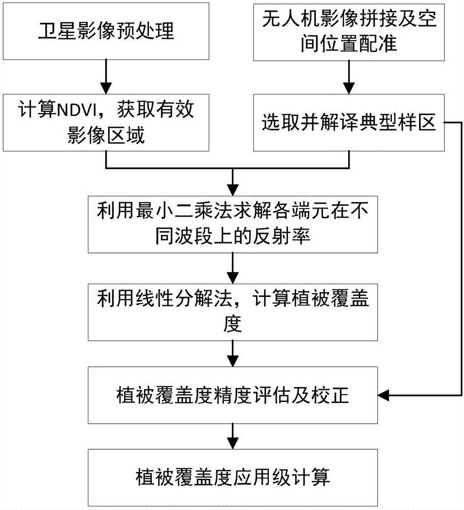
[0044] The present invention will be further described in detail below in conjunction with the embodiments and the accompanying drawings, but the embodiments of the present invention are not limited thereto. All other embodiments obtained by those skilled in the art without creative efforts fall within the protection scope of the present invention.

[0045] In this example, Landsat8OLI is used as the satellite remote sensing data source, and a karst area in southern my country is used as the experimental area. Combined with the features of the karst area, the types of ground vegetation are divided into three types: soil, vegetation, and rock.

[0046] Step 1: Obtain the Landsat8 image, and perform atmospheric correction on the image to eliminate the influence of radiation error caused by atmospheric scattering, and convert the DN value of the image into the real surface reflectance.

[0047] Perform geometric correction on atmospherically corrected images to obtain spatially p...


PUM


Abstract

The invention discloses a calculation method for large spatial scale vegetation coverage by combining with an unmanned aerial vehicle (UAV) image. The calculation method comprises the following steps: carrying out atmospheric correction and geometrical correction on a remote sensing image, calculating NDVI (Normalized Difference Vegetation Index) and obtaining an effective region according to a predetermined threshold value; splicing UAV pictures and obtaining an orthoimage, registering satellite data subjected to geometrical correction with the spatial position, selecting a typical sample area from the UAV image, and interpreting proportions of all ground objects in the typical sample area by using unsupervised classification; randomly selecting one part of the sample area, and solving the reflectivity of all ground object end elements by using the proportions of all the ground objects in the sample area and the corresponding satellite remote sensing band reflectivity and combining with a least square method; solving the vegetation coverage of all pixels in the effective image area by using a spectral decomposition model and the reflectivity of all the ground object end element; correcting calculation results of the vegetation coverage by using data of a residual sample area. The core of the calculation method disclosed by the invention is based on a method of acquiring the end-element reflectivity of the UAV and a vegetation coverage correction model, and the calculation accuracy of the large spatial scale vegetation coverage can be effectively improved.

Description

technical field [0001] The invention belongs to the application field of remote sensing technology, and in particular relates to a method for calculating vegetation coverage on a large spatial scale combined with drone images. Background technique [0002] Vegetation coverage is the ratio of the vertical projected area of ​​vegetation on the ground to the total area of ​​the region. It is an important parameter to describe the vegetation coverage on the surface of the ground. The important basic data of land surface processes are widely used in agriculture, forestry, resource and environment management, land use, hydro-ecological process, soil erosion investigation, disaster risk monitoring, drought monitoring and other fields. Due to its large-scale observation capability, remote sensing technology has become an important means to obtain regional and even global vegetation coverage. After decades of development, the vegetation coverage estimation method using remote sensin...

Claims


Application Information

Patent Timeline
IPC IPC(8): G01C11/00
CPCG01C11/00
Inventor 扶卿华亢庆王晓刚顾祝军
Owner PEARL RIVER HYDRAULIC RES INST OF PEARL RIVER WATER RESOURCES COMMISSION
Why Eureka
Try Eureka