Supercharge Your Innovation With Domain-Expert AI Agents!

Positioning unit and its method

A positioning unit and positioning data technology, applied in the field of global navigation satellite systems, can solve problems such as dead reckoning device errors, and achieve the effect of accurate positioning data

Inactive Publication Date: 2016-03-16
ACCTON TECHNOLOGY CORPORATION
View PDF4 Cites 0 Cited by
  • Summary
  • Abstract
  • Description
  • Claims
  • Application Information

AI Technical Summary

Problems solved by technology

However, position estimates from dead reckoning devices have large errors and can only be used for short periods of time

Method used


Image

  • Positioning unit and its method
  • Positioning unit and its method
  • Positioning unit and its method

Examples


Embodiment Construction

[0065] In order to make the purpose, features, and advantages of the present invention more obvious and understandable, the preferred embodiments are specifically cited below, together with the attached drawings Figure 1 to Figure 6 , give a detailed explanation. The description of the present invention provides different examples to illustrate the technical features of different implementations of the present invention. Wherein, the arrangement of each element in the embodiment is for illustration purpose, and is not intended to limit the present invention. Moreover, part of the reference numerals in the embodiments is repeated, for the sake of simplicity of description, it does not imply the correlation between different embodiments.

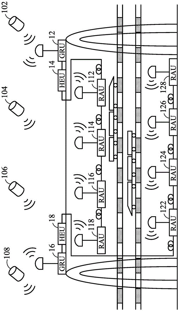
[0066] figure 1 It is a schematic diagram showing the configuration of a positioning system according to an embodiment of the present invention. Such as figure 1As shown, a first global navigation satellite system transceiver unit (GNSSRa...


PUM


Abstract

The invention provides a positioning unit and a method thereof. The positioning system includes first and second global navigation satellite system transceiver units and a positioning unit. The positioning unit includes first and second global navigation satellite system units, a dead reckoning unit and a geographic information system unit. The first and second global navigation satellite system units receive multiple global navigation satellite signals and generate first and second satellite positioning data respectively. The first and second global navigation satellite system units respectively receive the first and second satellite positioning data. The dead reckoning unit estimates the first positioning data and the second positioning data according to the measurement data, the first and the second satellite positioning data, and determines to output the positioning data. The GIS unit matches the output positioning data to a map as the final output of the positioning system. The positioning data provided by the invention is more accurate.

Description

technical field [0001] The present invention relates to a global navigation satellite system (Global Navigation Satellite System, hereinafter referred to as GNSS), in particular to a GNSS combined with a dead reckoning system (Dead Reckoning System). Background technique [0002] GNSS is a standard term for satellite navigation systems that provide independent global geospatial positioning. In the United States, GNSS is famous as the Global Positioning System (Global Positioning System, hereinafter referred to as GPS). A GNSS receiver determines its location based on wireless signals transmitted by satellites, including longitude, latitude, and altitude. GNSS receivers can also calculate precise time. Therefore, devices with GNSS receivers can easily obtain precise positioning data. For example, according to the navigation instructions of the GNSS device, the driver can easily drive the car to the destination. [0003] GNSS devices also have their drawbacks. There are m...

Claims


Application Information

Patent Timeline
Patent Type & Authority Patents(China)
IPC IPC(8): G01S19/42
CPCG01C21/165G01S19/11G01S19/47G01C21/12
Inventor 刘一如刘德曜
Owner ACCTON TECHNOLOGY CORPORATION
Features
  • R&D
  • Intellectual Property
  • Life Sciences
  • Materials
  • Tech Scout
  • Unparalleled Data Quality
  • Higher Quality Content
  • 60% Fewer Hallucinations
Learn More