Multi-person multi-dimensional remote sensing consultation collaborative studying and judging method and device

A multi-dimensional, remote sensing technology, applied in the field of remote sensing emergency monitoring and remote sensing interpretation, can solve the problem of lack of data real-time automatic synchronization, etc., to achieve the effect of facilitating communication and learning, improving multi-dimensional, accurate disaster situation and decision support

Inactive Publication Date: 2014-05-14
INST OF GEOGRAPHICAL SCI & NATURAL RESOURCE RES CAS +1
View PDF5 Cites 6 Cited by
  • Summary
  • Abstract
  • Description
  • Claims
  • Application Information

AI Technical Summary

Problems solved by technology

[0005] The embodiment of the present invention provides a multi-person multi-dimensional remote sensing consultation collaborative research and judgment method and device to provide a platform for experts in different places to conduct video consultations to perform collaborative multi-dimensional remote sensing interpretation of geological disasters, which solves the current geological disaster data analysis The lack of real-time and automatic data synchronization in the process helps users communicate seamlessly face-to-face and improves the efficiency of geological disaster interpretation

Method used


Image

  • Multi-person multi-dimensional remote sensing consultation collaborative studying and judging method and device
  • Multi-person multi-dimensional remote sensing consultation collaborative studying and judging method and device
  • Multi-person multi-dimensional remote sensing consultation collaborative studying and judging method and device

Examples


Embodiment Construction

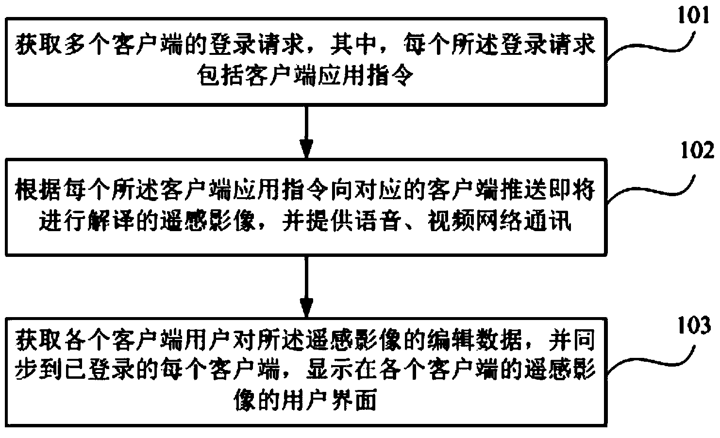
[0032] The following will clearly and completely describe the technical solutions in the embodiments of the present invention with reference to the accompanying drawings in the embodiments of the present invention. Obviously, the described embodiments are only some, not all, embodiments of the present invention. Based on the embodiments of the present invention, all other embodiments obtained by persons of ordinary skill in the art without making creative efforts belong to the protection scope of the present invention.

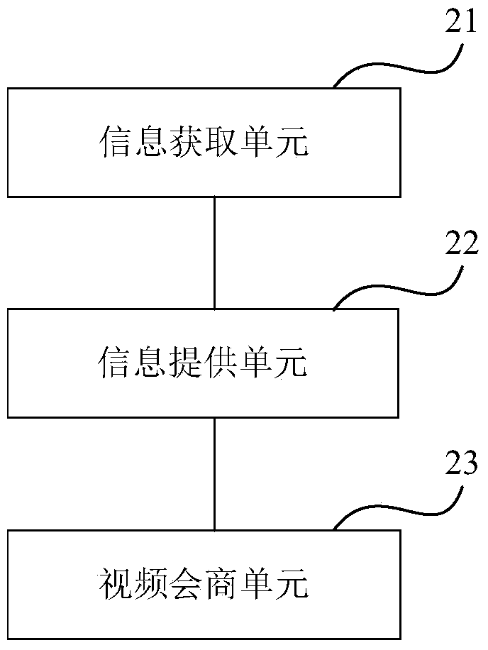
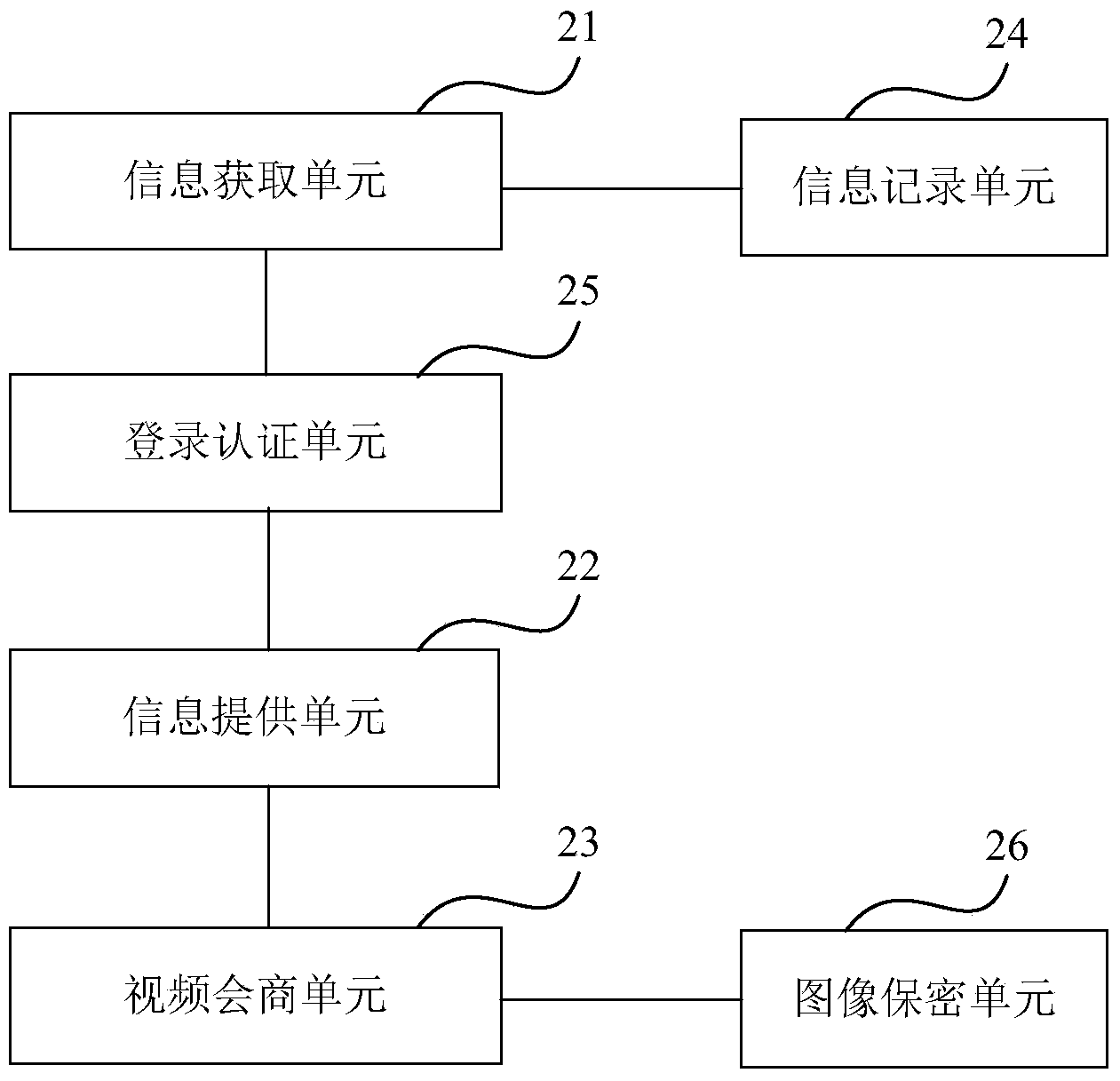
[0033] In order to achieve remote sensing image expert consultation and judgment in remote sensing emergency monitoring of geological disasters, multi-person collaboration, visual interpretation, comprehensive research and judgment, data sharing, and information interaction. The embodiment of the present invention provides a multi-person multi-dimensional remote sensing consultation collaborative research method and device to provide a platform for experts in d...


PUM


Abstract

The embodiment of the invention provides a multi-person multi-dimensional remote sensing consultation collaborative studying and judging method and device. The multi-person multi-dimensional remote sensing consultation collaborative studying and judging method includes the steps that login requests of a plurality of clients are obtained, wherein each login request comprises a client application instruction; remote sensing images to be interpreted are pushed to the corresponding clients according to the client application instructions, and voice and video network communication is provided; data, edited by client users, of the remote sending images are obtained, and the edited data are synchronously arranged in the logged-in clients and displayed on user interfaces of the remote sensing images of the clients. The method allows professionals at different places to perform multi-directional, consultative, collaborative studying and judging interpretation on the remote sensing images through audio and video communication under the support of the WEB-GIS and WEB-RS technologies. According to the method, the interpretation efficiency of the remote sensing images under the condition that significant events and emergencies (such as geological disasters) occur is improved, and a supporting means is provided for emergency monitoring through remote sensing.

Description

technical field [0001] The invention relates to the field of remote sensing emergency monitoring and remote sensing interpretation, in particular to a method and device for multi-person multi-dimensional remote sensing consultation and collaborative research and judgment. Background technique [0002] Judging from the current remote sensing emergency monitoring field and the development process of remote sensing interpretation, each country has deficiencies in the capabilities of "departmental linkage, remote collaboration, data coexistence, and information services" to varying degrees, but they also recognize these four capabilities. The development of remote sensing technology can maximize the utilization efficiency of remote sensing technology and provide more perfect services for real life and work. The platform that combines remote sensing image interpretation with video conferencing technology will effectively solve the above-mentioned lack of capabilities, promote the...

Claims


Application Information

Patent Timeline
Patent Type & Authority Applications(China)
IPC IPC(8): H04N7/15
Inventor 鲁学军薛安李柳柯武鹏达
Owner INST OF GEOGRAPHICAL SCI & NATURAL RESOURCE RES CAS
Why Eureka
Try Eureka