Global geographical name data integrating and encoding method

A technology of data integration and place names, applied in geographic information databases, electronic digital data processing, structured data retrieval, etc., can solve the problems of slow query speed and high construction costs, and achieve the promotion of comprehensiveness, uniqueness, and improvement of place name data information effect

Inactive Publication Date: 2014-06-04
BEIJING AEROSPACE TITAN TECH CO LTD
View PDF4 Cites 18 Cited by
  • Summary
  • Abstract
  • Description
  • Claims
  • Application Information

AI Technical Summary

Problems solved by technology

[0006] At present, many of the various GIS place name service systems that have been constructed are manual positioning, which is slow in query speed and high in construction costs. After the establishment of a global place name database, the positioning speed can be greatly improved and the labor cost can be reduced.

Method used


Image

  • Global geographical name data integrating and encoding method
  • Global geographical name data integrating and encoding method
  • Global geographical name data integrating and encoding method

Examples


Embodiment Construction

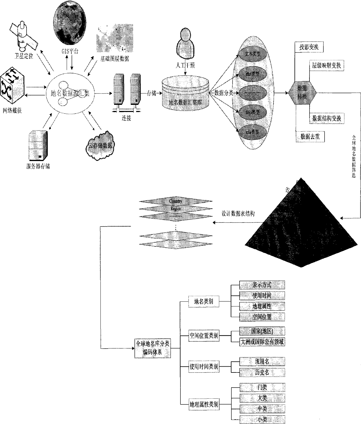
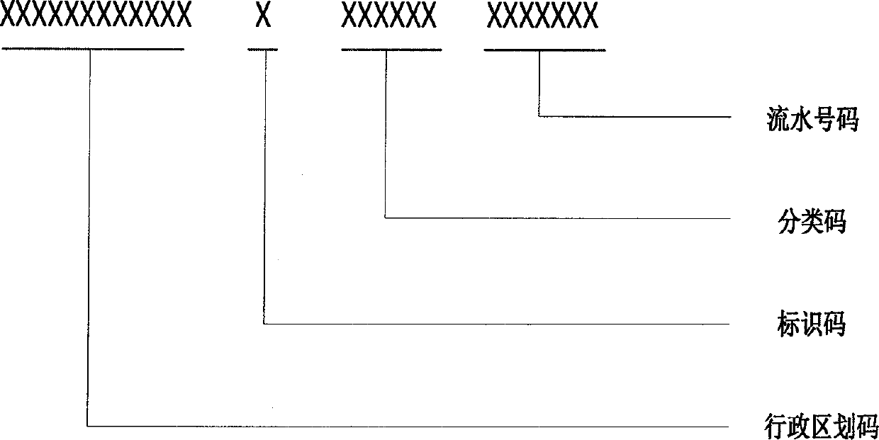
[0038] 1. Global geographical name data integration

[0039] 1. Data Collection

[0040]The data collection methods mainly include place name text data from Internet sites, vector data and image data from the GIS platform, historical data of research materials, and existing basic databases of cumulative results. Among them, the text data information intercepted through the Internet does not have spatial attribute information, and the collected form is recorded and stored in text; the vector and image information of place name data can be obtained through the GIS service platform, and the location of the positioning point can be determined according to the positioning function of the platform. Information collection, the main content of data collection refers to vector and remote sensing image information, spatial attribute information and other interest information are included in its attribute data table; historical data information obtained from research data may be text inf...


PUM


Abstract

The invention discloses a global geographical name data integrating and encoding method. GIS geographical name data information obtained through multiple channels is integrated and uniformly encoded to form a bank of global geographical names, domestic names are specified at the township level, and overseas names are specified at the county and municipal level. Design is conducted for the time characteristic and the space characteristic of the geographic name structure, and the global geographical name data integrating and encoding method combined with the traditional technology is put forward. The geographic data integrating process of the method includes the steps of organizing and classifying multi-source data, setting up the level mapping relation, and conducting projection conversion, data duplicate removal and the like, wherein geographic name data information can be more comprehensively completed, and the uniqueness, positioning accuracy and searching rapidness of geographic name data can be ensured. Meanwhile, on the basis that an existing national geographic name code standard is abided by and inherited, expanded encoding is conducted on the collected geographic name data, and the reasonable data table structure is designed. The method has the advantages of being large in data size, wide in coverage, high in accuracy and standard in encoding.

Description

technical field [0001] The present invention standardizes integration and unified coding of global place-name data by analyzing and collecting place-name data in different formats and types, and belongs to the technical field of GIS place-name service application (belonging to the field of cartography and geographic information system). Geographical name data integration production process and code compilation method. Background technique [0002] A place name is a code given to a specific geographical entity in the objective world, and it is a sign to distinguish a specific geographical entity from other geographical entities. As one of the most commonly used social public information, place names are not only closely related to people's daily life, but also an indispensable basic information resource for national administration, economic construction, and international exchanges. [0003] With the rapid development of social informatization, the establishment of global ge...

Claims


Application Information

Patent Timeline
Patent Type & Authority Applications(China)
IPC IPC(8): G06F17/30
CPCG06F16/29
Inventor 倪金生刘翔樊军伟
Owner BEIJING AEROSPACE TITAN TECH CO LTD
Why Eureka
Try Eureka