Cors-based gps control measurement method for long-distance pipeline

A long-distance pipeline and control measurement technology, applied in the field of GPS control measurement, can solve the problems of low efficiency and low precision of GPS control measurement technology, and achieve the effects of improving data accuracy, standardizing data processing, and flexible and convenient operation.

Active Publication Date: 2016-09-07
国家管网集团广东省管网有限公司 +1
View PDF1 Cites 0 Cited by
  • Summary
  • Abstract
  • Description
  • Claims
  • Application Information

AI Technical Summary

Problems solved by technology

[0004] The present invention aims to solve the technical problems of low precision and low efficiency of GPS control measurement technology in the prior art, and provides a CORS-based long-distance pipeline GPS control measurement method that can effectively improve measurement accuracy and save time

Method used


Image

  • Cors-based gps control measurement method for long-distance pipeline
  • Cors-based gps control measurement method for long-distance pipeline

Examples


Embodiment Construction

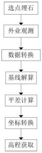
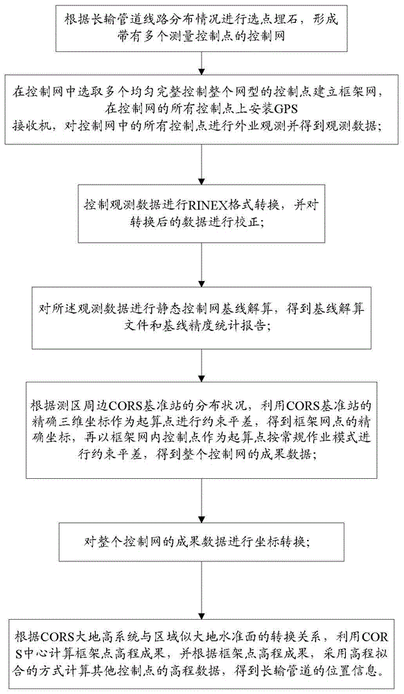
[0030] In order to make the technical problems, technical solutions and beneficial effects solved by the present invention clearer, the present invention will be further described in detail below in conjunction with the accompanying drawings and embodiments. It should be understood that the specific embodiments described here are only used to explain the present invention, not to limit the present invention.

[0031] CORS (Comprehensive System for Continuously Operating Satellite Positioning Services) is the product of network technology and GNSS (Global Navigation Satellite System) positioning technology, modern geodesy, and geodynamics. By establishing one or more continuously operating GNSS systems covering a certain area Reference stations, using computer network technology, provide users with a variety of data in real time or on time, including different types of GNSS observations (carrier phase, pseudo-range, etc.), various GNSS error correction numbers such as tropospher...


PUM


Abstract

A long-distance pipeline GPS control measurement method based on CORS comprises the steps of 1 performing point selection and stone filling according to the distribution situation of long-distance pipelines and forming a control network with multiple measurement control points; 2 performing field observation on the control points and obtaining observation data; 3 performing RINEX format conversion; 4 performing control network baseline solution on the observation data; 5 using accurate three-dimensional coordinates of CORS base stations as starting points to perform constrained adjustment according to the distribution situation of the CORS base stations on the periphery of a measurement region to obtain accurate coordinates of frame network nodes, then using control points in a frame network as starting points to perform constrained adjustment in a conventional operation mode to obtain result data of the whole control network; 6 performing coordinate conversion; 7 performing height fitting to calculate height data of other control points. The data accuracy and the working efficiency are effectively improved.

Description

technical field [0001] The invention belongs to the field of GPS control measurement, in particular to a CORS-based GPS control measurement method for long-distance pipelines. Background technique [0002] GPS (Global Positioning System) surveying work is similar to classic geodetic surveying work, and can be divided into two parts: field work and office work according to its nature. Among them: field work mainly includes point selection (that is, selection of observation site), establishment of observation marks, field observation operations, and quality inspection of results, etc.; office work mainly includes technical design of GPS measurement, post-measurement data processing, and technical summary Wait. According to the working procedure implemented by GPS measurement, it can be roughly divided into the following stages: technical design, point selection and establishment of signs, field observation, result verification and processing. [0003] The implementation of c...

Claims


Application Information

Patent Timeline
Patent Type & Authority Patents(China)
IPC IPC(8): G01S19/14G01C5/00
CPCG01C5/00G01S19/14
Inventor 王革许罡于桂章林其明李建辉
Owner 国家管网集团广东省管网有限公司
Why Eureka
Try Eureka