Al technical title is built by PatSnap Al team. It summarizes the technical point description of the patent document.
A navigation method and a navigation signal technology, applied in the field of navigation
Active Publication Date: 2014-07-23
BEIJING BDSTAR NAVIGATION CO LTD
View PDF6 Cites 12 Cited by
Summary
Abstract
Description
Claims
Application Information
AI Technical Summary
This helps you quickly interpret patents by identifying the three key elements:
Problems solved by technology
Method used
Benefits of technology
Problems solved by technology
[0004] The technical problem to be solved by the present invention is how to organically combine satellite navigat
Method used
Image
Click on the blue label to locate the original text in one second.
Reading with bidirectional positioning of images and text.
Examples
Example Embodiment
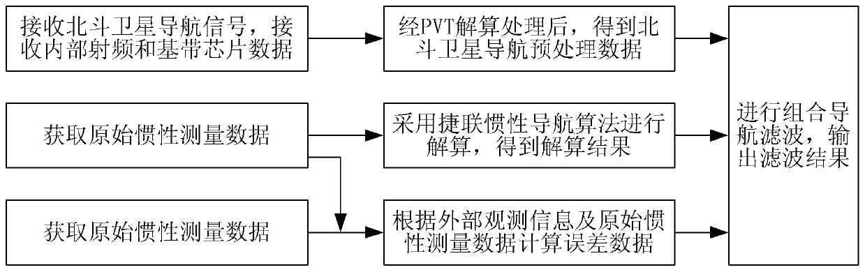
[0141] Embodiment 1. A navigation method, such as figure 1 Shown, including:
[0142] Receive Beidou satellite navigation signals, receive internal radio frequency and baseband chip data, and obtain Beidou satellite navigation pre-processed data after PVT (position, speed, time) calculation and processing;
[0143] Acquire original inertial measurement data, use strapdown inertial navigation algorithm to solve the original inertial measurement data, and obtain a solution result;
[0144] Obtain external observation information, and calculate error data based on the external observation information and the original inertial measurement data; the external observation information includes temperature, startup time, etc.;
[0145] Perform integrated navigation filtering according to the Beidou satellite navigation preprocessing data, the error data and the solution result, and output the filtering result.
[0146] This embodiment can also synchronously output the calculation results of Bei...
Example Embodiment
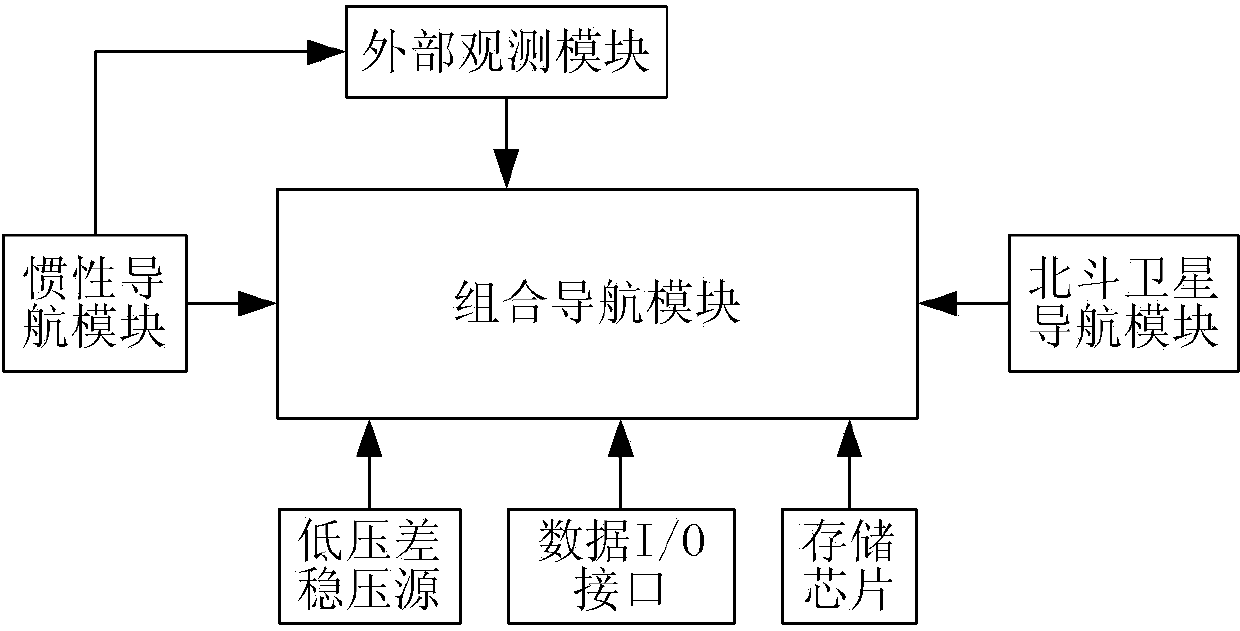
[0225] Embodiment 2. A navigation terminal, such as figure 2 As shown, the following modules are included:
[0226] The Beidou satellite navigation module is used to receive Beidou satellite navigation signals, receive internal radio frequency and baseband chip data, and obtain Beidou satellite navigation pre-processed data after PVT calculation;
[0227] Inertial navigation module, used to obtain original inertial measurement data; use strap-down inertial navigation algorithm to solve the original inertial measurement data to obtain the solution result;
[0228] The external observation module is used to obtain external observation information, and calculate error data based on the external observation information and the original inertial measurement data; the external observation information includes temperature and startup time;
[0229] The integrated navigation module is used to perform integrated navigation filtering according to the Beidou satellite navigation preprocessed dat...
PUM
Abstract
The invention provides a navigation method and terminal. The navigation method includes the steps of receiving a Beidou satellite navigation signal, receiving internal radio frequency and base band chip data, and obtaining Beidou satellite navigation preprocessed data after position, speed and time resolving processing; obtaining external observation information and original inertia measurement data; calculating error data according to the external observation information and the original inertia measurement data, wherein the external observation information includes the temperature and the starting time; resolving the original inertia measurement data with a strapdown inertial navigation algorithm to obtain the resolving result; carrying out combined navigation filtering according to the Beidou satellite navigation preprocessed data, the error data and the resolving result, and outputting the filtering result. By means of the navigation method and terminal, satellite navigation and inertia navigation are organically combined, and the navigation accuracy and the navigation reliability which are superior to the navigation accuracy and the navigation reliability of any single navigation system are achieved.
Description
technical field [0001] The invention relates to the field of navigation, in particular to a navigation method and a navigation terminal. Background technique [0002] The global satellite navigation system (GNSS) can provide all-weather, continuous and precise three-dimensional positioning and navigation services on a global scale. It has been widely used in the navigation and positioning of aviation, spaceflight, navigation and ground vehicles. The independently developed and independently operated global satellite navigation system implemented is an independent, open and compatible, technologically advanced, stable and reliable satellite navigation system. The outstanding advantage of the Beidou satellite navigation system is that its navigation and positioning accuracy is high, and the navigation and positioning accuracy is basically not limited by time and region. However, when the satellite signal is blocked or interfered, its advantages cannot be brought into play, an...
Claims
Application Information
Patent Timeline
Application Date:The date an application was filed.
Publication Date:The date a patent or application was officially published.
First Publication Date:The earliest publication date of a patent with the same application number.
Issue Date:Publication date of the patent grant document.
PCT Entry Date:The Entry date of PCT National Phase.
Estimated Expiry Date:The statutory expiry date of a patent right according to the Patent Law, and it is the longest term of protection that the patent right can achieve without the termination of the patent right due to other reasons(Term extension factor has been taken into account ).
Invalid Date:Actual expiry date is based on effective date or publication date of legal transaction data of invalid patent.