Co-location method of AUVs (Autonomous Underwater Vehicles) in curvilinear motion state based on polar coordinate system

A polar coordinate system and co-location technology, applied in the directions of measuring devices, instruments, surveying and navigation, etc., can solve the problem that distance information cannot describe the motion state of AUV well.

Active Publication Date: 2014-08-06
HARBIN ENG UNIV
View PDF3 Cites 15 Cited by
  • Summary
  • Abstract
  • Description
  • Claims
  • Application Information

AI Technical Summary

Problems solved by technology

At present, most of the AUV collaborative positioning systems are established based on the Cartesian coordinate system, and most of their motion states are straight and constant speed, while the polar coordinate system is for curved motion, so a collaborative positioning system based on the polar coordinate system is proposed. In addition, when the AUV is moving in a curve, the pure distance information cannot describe the motion state of the AUV well, so a collaborative navigation positioning algorithm using distance plus azimuth information as the observation is proposed and the observability is carried out. analyze

Method used


Image

  • Co-location method of AUVs (Autonomous Underwater Vehicles) in curvilinear motion state based on polar coordinate system
  • Co-location method of AUVs (Autonomous Underwater Vehicles) in curvilinear motion state based on polar coordinate system
  • Co-location method of AUVs (Autonomous Underwater Vehicles) in curvilinear motion state based on polar coordinate system

Examples


Embodiment Construction

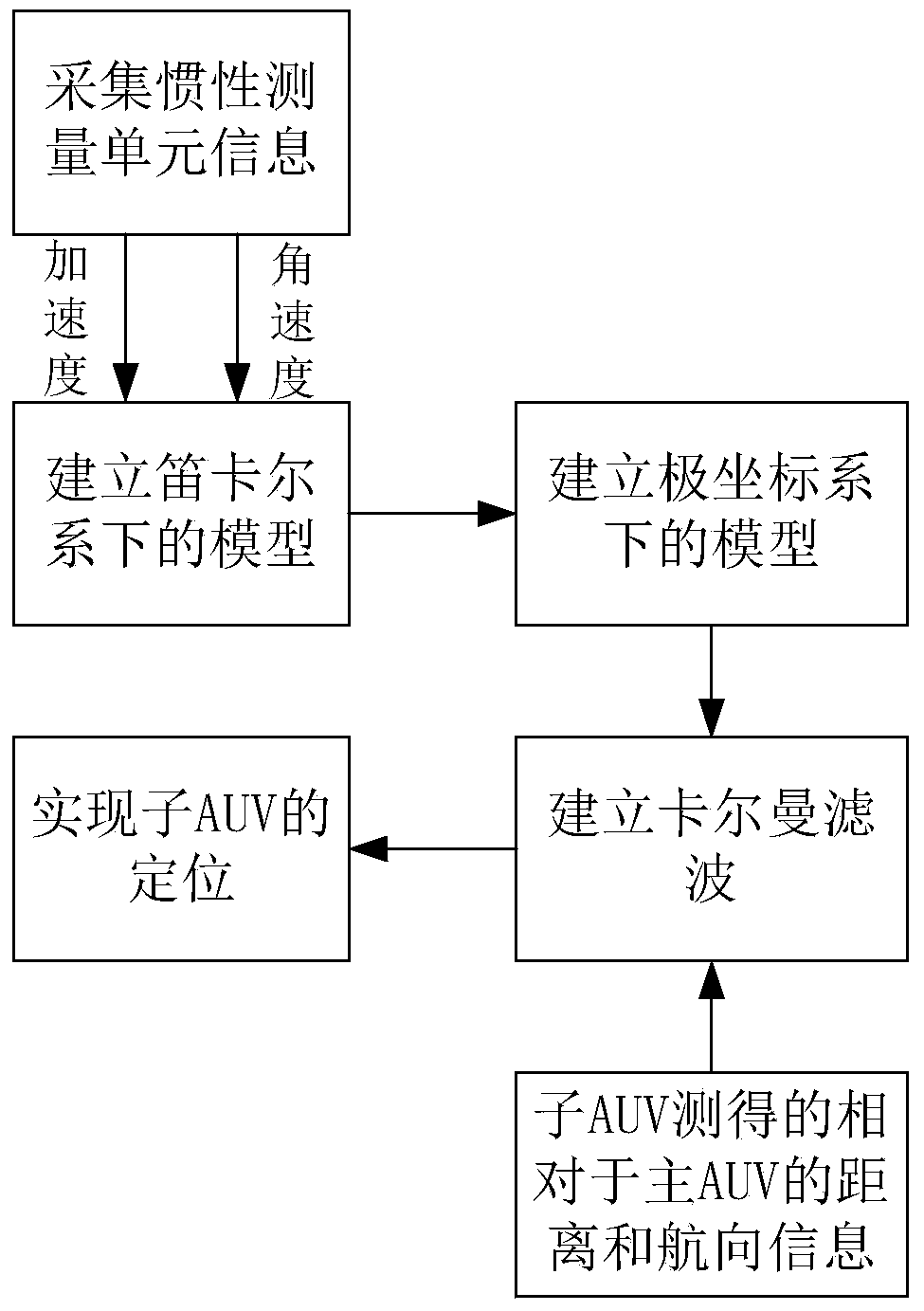
[0055] The present invention will be further described in detail below in conjunction with the accompanying drawings.

[0056] The new co-location algorithm based on the polar coordinate system under the AUV curve motion state includes the following steps:

[0057] Step 1: Collect acceleration and angular velocity information measured by an inertial measurement unit (Inertial Measurement Unit, IMU).

[0058] Step 2: Use the acceleration information and angular velocity information measured by the IMU to integrate the velocity and heading information of the carrier AUV, and use this information to establish the system equation of the AUV in the traditional Cartesian coordinate system.

[0059] Step 3: Using the conversion relationship between the polar coordinate system and the Cartesian coordinate system in step 2, the system equation of the AUV in step 2 is transformed into polar coordinates.

[0060] Step 4: Collect the distance and orientation information of the sub-AUV re...


PUM


Abstract

The invention provides a co-location method of AUVs (Autonomous Underwater Vehicles) in a curvilinear motion state based on a polar coordinate system. A main AUV is equipped with an IMU (Inertial Measurement Unit) with high precision, and sub SUVs are equipped with IMUs with relatively low precision. The co-location method comprises the steps of measuring motion information of a carrier by fusion of the IMUs of the sub AUVs, measuring information of distances and orientations of the sub AUVs relative to the main AUV, and finally, performing co-location by virtue of EKF (Extend Kalman Filter). Compared with a traditional algorithm based on a Cartesian coordinate system, the co-location method is higher in precision when the AUVs do curvilinear motion.

Description

technical field [0001] The invention relates to a collaborative positioning method in a curved motion state of an AUV based on a polar coordinate system in a curved motion state. Background technique [0002] The future is the century of marine civilization, and the exploration of the marine field will become the development trend of the world. Therefore, the research on the operation and application of surface ships has broad prospects. Autonomous Underwater Vehicle (AUV) is actually an underwater unmanned platform, which has become a research hotspot due to its advantages of small size, strong mobility and low cost; it can perform various navigations and underwater geographical surveys, etc. Complex tasks [1]. As humans further develop and understand the ocean, the theoretical value and practical significance of AUV research and application are more prominent. Compared with conventional boats, AUV is easy to operate, flexible and fast, and can withstand the test of vario...

Claims


Application Information

Patent Timeline
Patent Type & Authority Applications(China)
IPC IPC(8): G01C21/16G01C21/20
CPCG01C21/16G01C21/203
Inventor 高伟史宏洋刘博杨建于春阳张丽丽张亚梁宏兰海钰夏建忠
Owner HARBIN ENG UNIV
Why Eureka
Try Eureka