Method, device and system for navigation of electric automobile
A technology for electric vehicles and batteries, applied in the field of intelligent navigation, can solve the problems of inability to grasp the cruising range of electric vehicles and low navigation efficiency.
- Summary
- Abstract
- Description
- Claims
- Application Information
AI Technical Summary
Problems solved by technology
Method used
Image
Examples
Embodiment 1
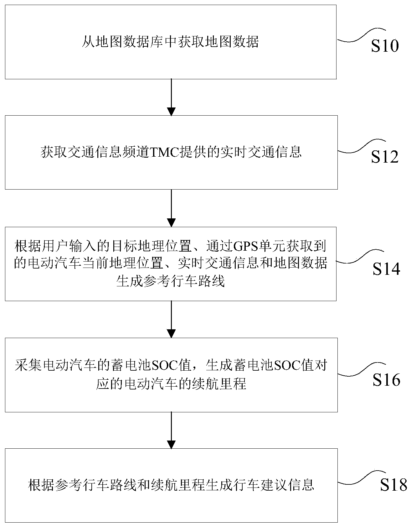
[0023] The embodiment of the present invention provides a navigation method based on an electric vehicle. Such as figure 1 As shown, the electric vehicle-based navigation method includes the following steps:
[0024] Step S10: Obtain map data from the map database.
[0025] Specifically, the above-mentioned map database may include all map data within a certain geographic area. For example, if the electric vehicle is in China, this solution can obtain the map data of China from the above-mentioned map database.
[0026] Step S12: Acquire real-time traffic information provided by the traffic information channel TMC.
[0027] Specifically, the traffic information channel TMC in step S12 may be an open data application (Open Date Applications, ODA) that generates real-time traffic information and weather conditions by means of RDS (an FM subcarrier system). In an alternative embodiment, the real-time traffic information provided by the traffic information channel TMC can be obtained th...
Embodiment 2
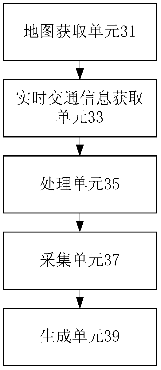
[0079] The embodiment of the present invention also provides an electric vehicle-based navigation device, such as image 3 As shown, the device may include:
[0080] The map obtaining unit 31 is configured to obtain map data from a map database.
[0081] Specifically, the navigation of an electric vehicle first needs to obtain map data from the database to achieve map matching, that is, use digital map information to fuse sensor position data to generate the best position estimate, which is to combine the driving track of the electric vehicle with the road in the electronic map database. The network compares, finds the route closest to the driving track on the map, and maps the actual positioning data to an intuitive digital map.
[0082] Map matching coordinates the display error between the positioning information and the road information of the electronic map, and the positioning point is forced to register with the actual road according to a certain rule, so as to ensure that the...
Embodiment 3
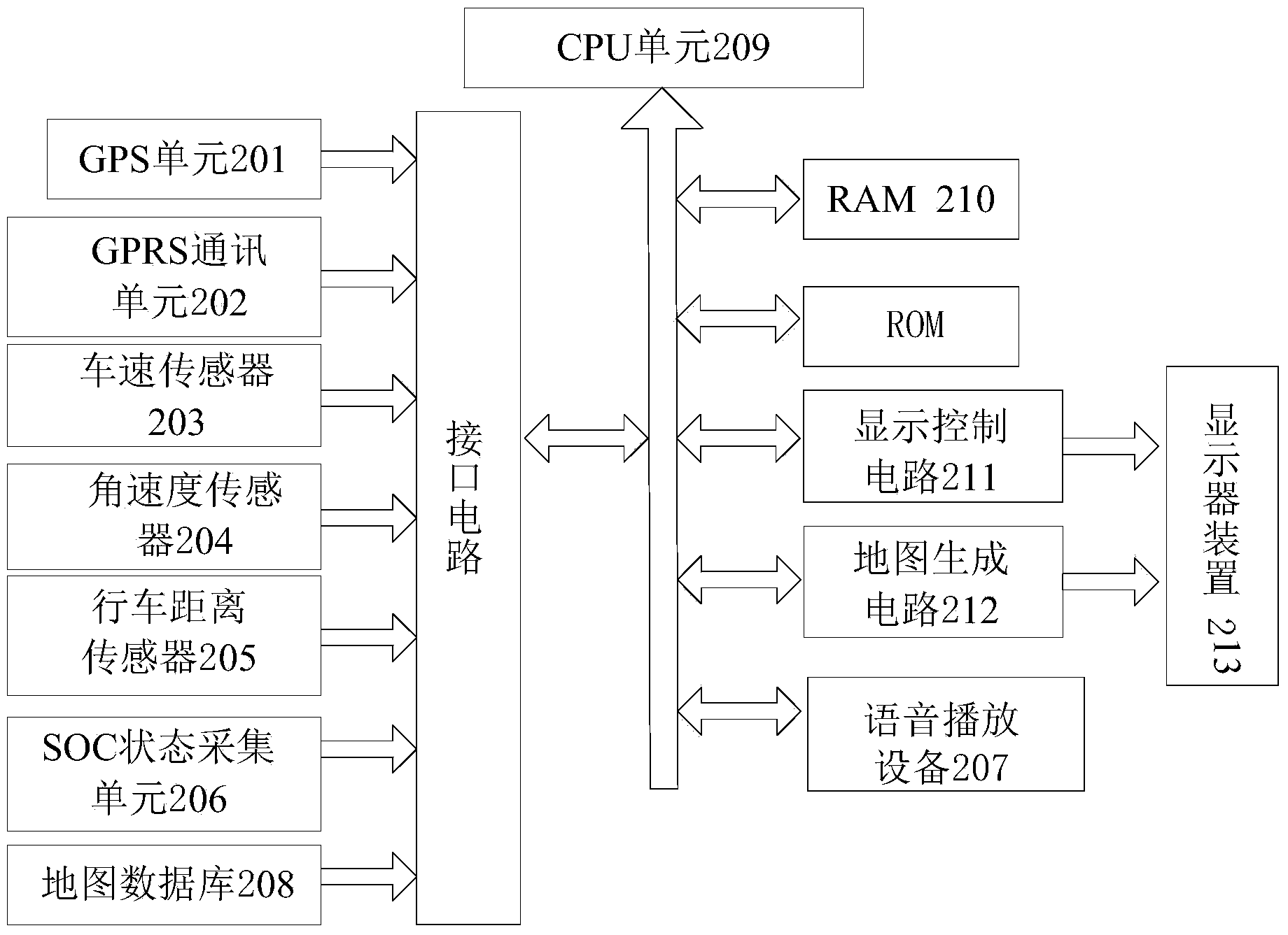
[0099] The embodiment of the present invention also provides a navigation system based on electric vehicles, such as Figure 4 As shown, the system includes a vehicle speed sensor 401, an angular velocity sensor 402, a driving distance sensor 403, a map database 404, a GPS unit 405, an SOC state collection unit 406, and a CPU unit 407.
[0100] Among them, the vehicle speed sensor 401 is used to detect the vehicle speed of the electric vehicle. The angular velocity sensor 402 is used to measure the change of the rotation angle of the rotating body. The sensor alone cannot measure the acceleration, and the change of the rotation angle must be processed and displayed by the secondary instrument to complete the measurement. The driving distance sensor 403 is used to measure the distance traveled by the vehicle this time.
[0101] The map database 404 is used to store map data and display it on the screen to form a map image.
[0102] Specifically, the above-mentioned map database may i...
PUM
 Abstract
Description
Claims
Application Information
 - R&D
- Intellectual Property
- Life Sciences
- Materials
- Tech Scout
- Unparalleled Data Quality
- Higher Quality Content
- 60% Fewer Hallucinations
Browse by: Latest US Patents, China's latest patents, Technical Efficacy Thesaurus, Application Domain, Technology Topic, Popular Technical Reports.
© 2025 PatSnap. All rights reserved.Legal|Privacy policy|Modern Slavery Act Transparency Statement|Sitemap|About US| Contact US: help@patsnap.com


