Automatic horizon tracking method adopting dip angle propagation method

A layer tracking and automatic tracking technology, applied in the field of oil and gas exploration and development, can solve problems such as stack overflow, large amount of seismic data, recursive call function time and space occupation, etc., to enhance continuity and improve accuracy Effect

Active Publication Date: 2015-02-25
BC P INC CHINA NAT PETROLEUM CORP +1
View PDF5 Cites 13 Cited by
  • Summary
  • Abstract
  • Description
  • Claims
  • Application Information

AI Technical Summary

Problems solved by technology

[0020] The recursive flood filling method increases the recursive level when the filling area is large, and the stack overflow of the operating system will be caused by repeated calls of the function, especially because the data volume of

Method used


Image

  • Automatic horizon tracking method adopting dip angle propagation method
  • Automatic horizon tracking method adopting dip angle propagation method
  • Automatic horizon tracking method adopting dip angle propagation method

Examples


Embodiment Construction

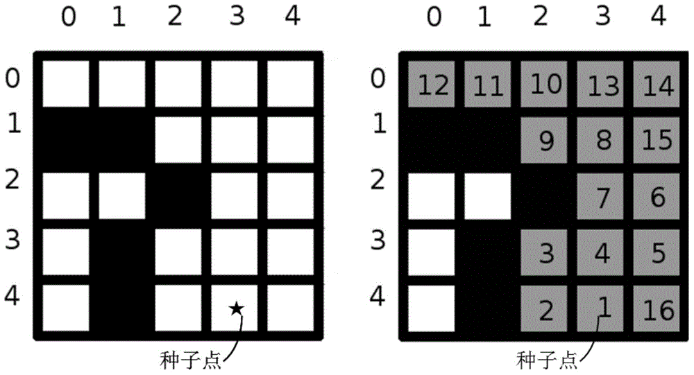
[0073] According to the characteristics of seismic data and the requirements of seismic layer tracking, the present invention transforms the classic "Flood Fill" image processing technology, constructs an "Inverse Flood Fill" algorithm, and uses various technologies to enhance the seismic layer It can improve the continuity of layer tracking and improve the accuracy of layer tracking near faults. The invention can be applied to two-dimensional seismic horizon automatic tracking and three-dimensional seismic horizon automatic tracking.

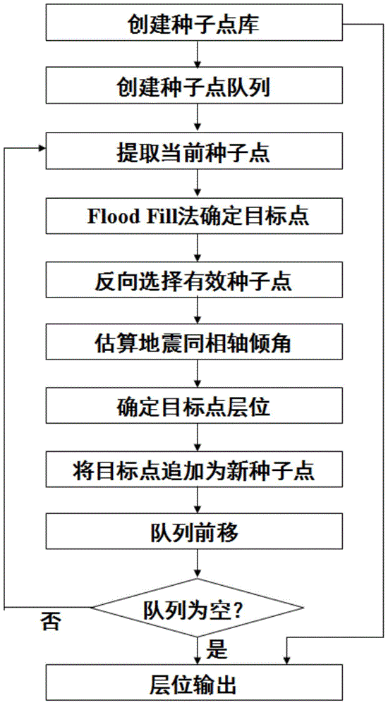
[0074] According to the content of the invention of the present invention, the present invention has the following implementation steps ( figure 1 ):

[0075] (1) Determine the seismic horizon on the seismic profile according to the geological research target, pick up the seed points, and create the seed point library;

[0076] The creation of the seed point library is as follows: first, for different geological research targets, select the t...


PUM


Abstract

The invention relates to a seismic data structural interpretation technology, and provides an automatic horizon tracking method adopting a dip angle propagation method. The classic flood fill image processing technology is modified according to the characteristics of seismic data and the seismic horizon tracking requirement, an inverse flood fill algorithm is constructed, and automatic horizon tracking is achieved through reserve seed point searching, stratum damping coefficient setting, fault blocking and other technologies. By means of the method, seismic horizon tracking continuity can be enhanced, accuracy of horizon tracking near a fault is improved, the requirement for high-precision automatic horizon tracking and efficient seismic data structural interpretation are met, and the automatic horizon tracking method can be used for horizon tracking of a two-dimensional work area and a three-dimensional work area.

Description

technical field [0001] The invention relates to oil and gas exploration and development technology, and belongs to an automatic layer tracking method under the control of formation dip angle in structural interpretation of seismic data. Background technique [0002] Structural interpretation and analysis of seismic data is an important stage of seismic exploration engineering. At this stage, seismic data can be used to find out the characteristics of underground structures and provide basic information for finding favorable oil and gas reservoirs and oil and gas reservoirs. Structural feature analysis based on seismic data is not only the basis of reservoir feature analysis but also directly affects the quality of reservoir feature analysis. [0003] The seismic horizon refers to the seismic reflection interface corresponding to a stratum in the subsurface medium. Generally, in the same fault block, a seismic reflection interface appears as a seismic reflection event that c...

Claims


Application Information

Patent Timeline
IPC IPC(8): G01V1/28
Inventor 陈茂山詹仕凡于海生郝彦国赵海珍左红光
Owner BC P INC CHINA NAT PETROLEUM CORP
Why Eureka
Try Eureka