High-resolution construction land graph spot identification method based on PanTex and linear characteristic

A high-resolution, straight-line feature technology used in character and pattern recognition, instrumentation, computer components, etc.

Inactive Publication Date: 2015-03-11
中国土地勘测规划院
View PDF3 Cites 12 Cited by
  • Summary
  • Abstract
  • Description
  • Claims
  • Application Information

AI Technical Summary

Problems solved by technology

[0004]From a technical point of view, existing construction land extraction methods can be divided into two types of research directions: one type usually divides construction land into specific research objectives, such as Roads, airports, buildings, ports, etc., and then perform target extraction or classification; another type uses the construction land as a whole to mine its structural or texture features, or uses the construction land as man-made objects (man-made objects) Collective research, the representative result of this type of research is the PanTex index proposed by Martino Pesaresi (detailed reference: A.G.Martino Pesaresi, Francois Kayitakire, "A robust built-up area presence index by anisotropic rotation-invariant textural measure," IEEE Journal of selected topics in applied earth observations and remote sensing, vol.1, pp.180-192, 2008), but the optimal resolution of the index to extract construction land is 5 meters, especially in high spatial resolution remote sensing images, the resolution is better than In the 1-meter high-resolution image, especially when there are areas such as large factory buildings and large roofs in the image, PanTex can hardly indicate these areas

Method used


Image

  • High-resolution construction land graph spot identification method based on PanTex and linear characteristic
  • High-resolution construction land graph spot identification method based on PanTex and linear characteristic
  • High-resolution construction land graph spot identification method based on PanTex and linear characteristic

Examples


Embodiment Construction

[0070] The following will refer to Attached picture The present invention will be described in detail in conjunction with the embodiments.

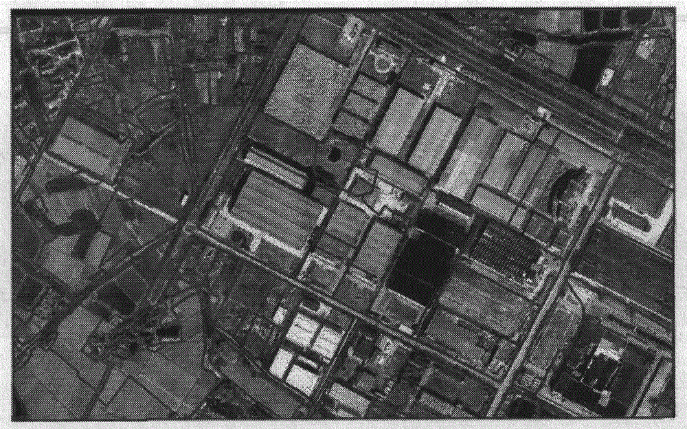
[0071] The present invention uses the WorldViewl panchromatic image and the land use of the corresponding time phase in Wujin District, Jiangsu Province picture Taking Spot as an example, the experimental image was shot in December 2012.

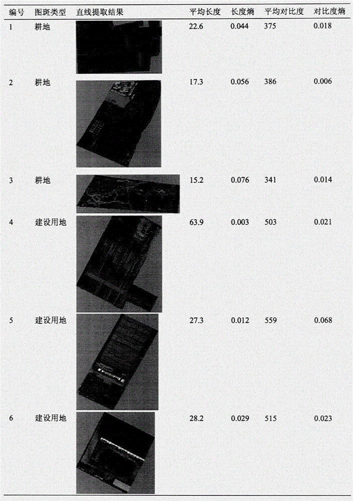
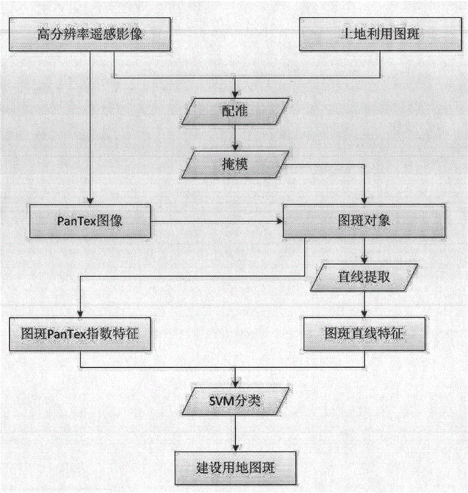
[0072] figure 1 Shows high-resolution building land based on PanTex indices and line features picture The flow process of spot recognition method, comprises the following steps:

[0073] Step 1. High-resolution remote sensing images and corresponding land use picture spot for image and vector registration;

[0074] land use picture Spot refers to a component of land use elements in the land use database. It is a vector file composed of a series of polygons. The file format is mainly ESRI Shapefile. Each polygon in the vector file contains the spatial information and attribute information of th...


PUM


Abstract

The invention discloses a high-resolution construction land graph spot identification method based on PanTex and a linear characteristic. The method comprises the following specific steps: step one, performing registering on high-resolution remote sensing images and corresponding land utilization graph spots; step two, performing superposing mask on the land utilization graph spots and the high-resolution remote sensing images to obtain independent graph spot images corresponding to graph spot polygons; step three, calculating the PanTex characteristic images of the high-resolution remote sensing images after processing, and counting the sum of PanTex indexes in each graph spot; step four, extracting straight lines in graph spot images for the independent graph spot images after the processing; step five, calculating the linear characteristics of the graph spots; and step six, classifying the graph spots by use of two types of SVM classifiers, and extracting construction land graph spots. According to the invention, the problem of failure of the PanTex indexes in large workshops and large roofs in the high-resolution remote sensing images is solved, the algorithm is simple and highly-efficient, the result is in the form of the graph spots, and a GIS database can be conveniently updated.

Description

technical field [0001] The invention belongs to the technical field of remote sensing image processing, and mainly relates to construction land in land use databases picture A method for spot recognition, specifically involving a high-resolution construction land based on PanTex and line features picture spot recognition method. Background technique [0002] The use of satellite remote sensing technology to carry out land resource survey has a rapid development in our country. As early as the early 1980s, my country adopted satellite and aerial imagery picture Carry out land resource surveys nationwide at 1:10,000 in agricultural areas, 1:25,000 in forest areas, and 1:50,000-1:100,000 in pastoral areas. 1996, nation The Bureau of Land Management organized the application of Landsat TM data to monitor the construction land scale of 17 cities. In the second national land survey started in 2007, high, medium and low resolutions and the combination of macro and micro metho...

Claims


Application Information

Patent Timeline
Patent Type & Authority Applications(China)
IPC IPC(8): G06K9/62
CPCG06F18/2411
Inventor 尤淑撑孟瑜武斌刘顺喜岳安志陈静波王忠武袁媛沈均平
Owner 中国土地勘测规划院
Why Eureka
Try Eureka