Unpiloted system navigation control method based on global positioning system or mobile communication network

A technology of mobile communication network and satellite positioning system, which is applied in the field of navigation of unmanned driving system, and can solve problems such as inaccurate routes, difficult targets of unmanned driving system, endangering national and social security, etc.

Active Publication Date: 2015-04-01
黑龙江云顶航空科技有限公司
View PDF9 Cites 19 Cited by
  • Summary
  • Abstract
  • Description
  • Claims
  • Application Information

AI Technical Summary

Problems solved by technology

[0002] At present, the unmanned driving system is developing rapidly and has been widely used in the military and civilian fields. However, due to the radio remote control of the unmanned system itself or the characteristics of its own program control, the route is not accurate and it is inevitable to drive into a specific area. It will...

Method used


Image

  • Unpiloted system navigation control method based on global positioning system or mobile communication network

Examples


Embodiment Construction

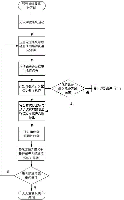
[0018] Combine below figure 1 A method for controlling the navigation of an unmanned system based on a satellite positioning system or a mobile communication network of the present invention is further described:

[0019] A method of controlling the navigation of an unmanned system based on a satellite positioning system or a mobile communication network of the present invention uses a satellite positioning system or a mobile communication network to monitor the path and navigation process of the unmanned system, and then avoids a specific area. When entering an area to be avoided for any reason, take emergency measures, and the specific steps are as follows:

[0020] a. After the navigable area and avoidance area are preset in the remote background (that is, the control background) and / or the unmanned system, the navigation route and avoidance point are preset; and the country is pre-installed in the remote background and the unmanned system Information on no-fly areas deter...


PUM


Abstract

The invention discloses an unpiloted system navigation control method based on a global positioning system or a mobile communication network, and relates to an unpiloted system navigation method. The unpiloted system navigation control method comprises the following steps: using the global positioning system or the mobile communication network to monitor the navigation process of the unpiloted system, according to the parameters obtained by monitoring, calculating to obtain the current navigation track of the unpiloted system, so as to avoid certain regions, and adopt emergency treatment method when the unpiloted system accidentally enters the region required to be avoided. The unpiloted system navigation control method disclosed by the invention completely uses the positioning function of the satellite positioning system and the mobile communication network, and utilizes the compensating parameter obtained through measurement by the mobile communication network to correct the motion parameter obtained through measurement by the satellite positioning system, so as to obtain the relatively accurate navigation track; according to comparison between the navigation track and the preset route, the method can accurately correct the navigation state of the unpiloted system to be matched with the preset route; meanwhile the avoiding region is preset in the navigation region, so that the unpiloted system can automatically avoid the avoiding region.

Description

technical field [0001] The invention relates to a navigation method of an unmanned system, in particular to a method for controlling navigation of an unmanned system based on a satellite positioning system or a mobile communication network. Background technique [0002] At present, the unmanned driving system is developing rapidly and has been widely used in the military and civilian fields. However, due to the radio remote control of the unmanned system itself or the characteristics of its own program control, the route is not accurate and it is inevitable to drive into a specific area. It will make it difficult to fully realize the expected goals of the unmanned driving system and endanger the security of the country and society. It will increasingly become an obstacle restricting the development of unmanned driving systems. As the scale of unmanned driving system development continues to expand, this problem is particularly urgent . Contents of the invention [0003] T...

Claims


Application Information

Patent Timeline
IPC IPC(8): G05D1/02G05D1/10
Inventor 徐嘉荫
Owner 黑龙江云顶航空科技有限公司
Why Eureka
Try Eureka