Eureka AIR delivers breakthrough ideas for toughest innovation challenges, trusted by R&D personnel around the world.

A video map-based disaster rescue simulation training method and system

A technology for simulating training and video, applied in the field of video maps, can solve the problems of fusion of real space and video space, poor training effect, etc., and achieve the effect of reducing costs

Active Publication Date: 2018-06-22
SHENZHEN INST OF ADVANCED TECH
View PDF4 Cites 0 Cited by
  • Summary
  • Abstract
  • Description
  • Claims
  • Application Information

AI Technical Summary

Problems solved by technology

[0003] The present invention provides a disaster lifesaving simulation training method and system based on a video map, aiming to solve the problem that the existing emergency and lifesaving training cannot integrate the real space and the video space, thereby simulating various disaster scenarios and enabling users to Conducting life-saving training in an immersive experience, resulting in poor training results due to technical problems

Method used


Image

  • A video map-based disaster rescue simulation training method and system
  • A video map-based disaster rescue simulation training method and system
  • A video map-based disaster rescue simulation training method and system

Examples


Embodiment Construction

[0033] In order to make the object, technical solution and advantages of the present invention clearer, the present invention will be further described in detail below in conjunction with the accompanying drawings and embodiments. It should be understood that the specific embodiments described here are only used to explain the present invention, not to limit the present invention.

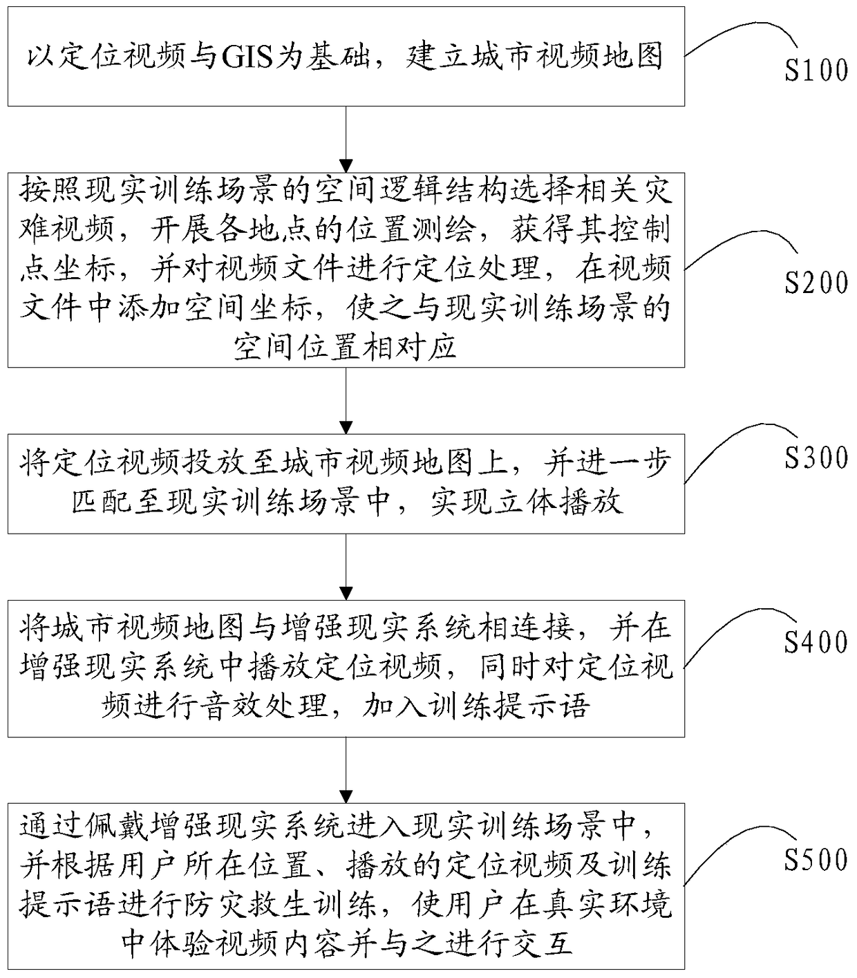
[0034] see figure 1 , is a flowchart of a video map-based disaster rescue simulation training method according to an embodiment of the present invention. The disaster rescue simulation training method based on the video map of the embodiment of the present invention comprises the following steps:

[0035] Step 100: Based on the positioning video and GIS, a city video map is established;

[0036] In step 100, the method for establishing a city video map is as follows: through video surveying and mapping and coordinateization, the city monitoring video is projected onto the electronic map according...


PUM


Abstract

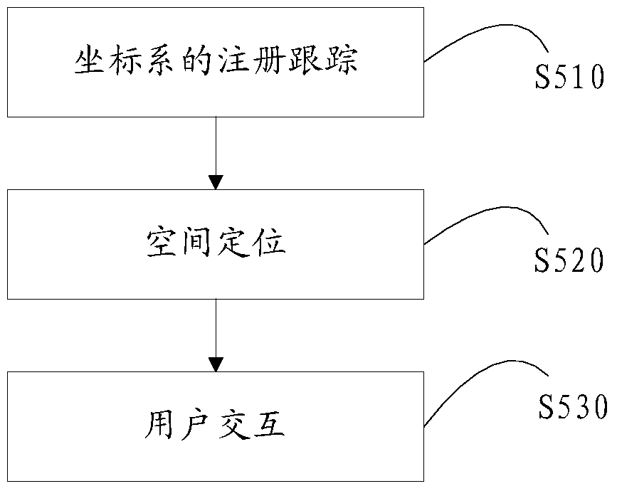
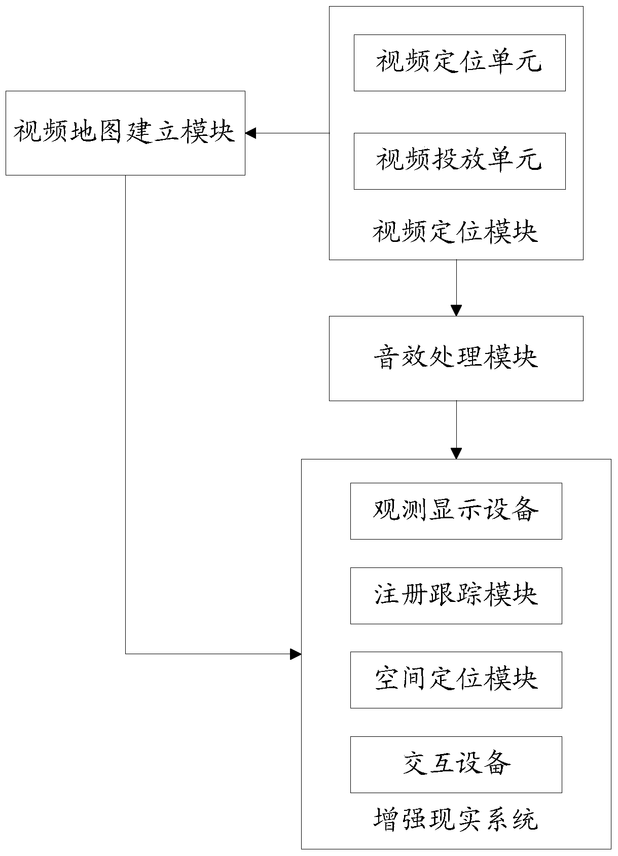
The invention belongs to the technical field of video maps, and particularly relates to a disaster lifesaving simulated training method and a disaster lifesaving simulated training system based on the video map. The disaster lifesaving simulated training method based on the video map comprises the following steps: step a, based on located video and GIS (Geographic Information System), establishing an urban video map; step b, selecting a disaster video file, performing the locating treatment on the video file, adding space coordinates, enabling the located video to be displayed on the urban video map and to corresponds to the actual training site; step c, using an augmented reality system to display the located video, wearing the augmented reality system by a user to enter the actual training scene, and performing disaster-preventing lifesaving training according to the user location and the displayed located video. The disaster lifesaving simulated training method and the system disclosed by the invention display the located video, and integrate the augmented reality technology to simulate various disaster scenes, so as to enable the user to receive the lifesaving training in the reality-simulating scene and achieve a high sense of reality.

Description

technical field [0001] The invention belongs to the technical field of video maps, in particular to a video map-based disaster rescue simulation training method and system. Background technique [0002] Carrying out disaster emergency and lifesaving training and improving the public's ability to protect themselves has become a major issue in public security and social governance today. However, due to management and technical reasons, the existing emergency and lifesaving training cannot integrate real space and video space to simulate Various disaster scenarios enable users to carry out life-saving training in an immersive experience, resulting in poor training results. Contents of the invention [0003] The present invention provides a disaster lifesaving simulation training method and system based on a video map, aiming at solving the problem that the existing emergency and lifesaving training cannot integrate the real space and the video space, thereby simulating vario...

Claims


Application Information

Patent Timeline
Patent Type & Authority Patents(China)
IPC IPC(8): H04N7/18H04N13/00G06F17/30
Inventor 修文群
Owner SHENZHEN INST OF ADVANCED TECH
Why Eureka
Eureka Blog
Learn More