Distributed GIS accelerating system and GIS service processing method
A technology for accelerating systems and processing methods, applied in the field of GIS, and can solve problems such as low access efficiency
- Summary
- Abstract
- Description
- Claims
- Application Information
AI Technical Summary
Problems solved by technology
Method used
Image
Examples
Embodiment 1
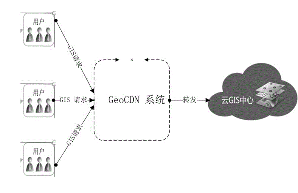
[0032] This embodiment provides a distributed GIS acceleration system (GeoCDN system), which is set between the client and the cloud GIS center, such as figure 1 As shown, the GeoCDN system receives the GIS request from the client user. If the GeoCDN system can process the received GIS request, the GeoCDN system will complete the processing of the GIS request. If the GeoCDN system cannot process the received GIS request , and then forwarded to the cloud GIS center.
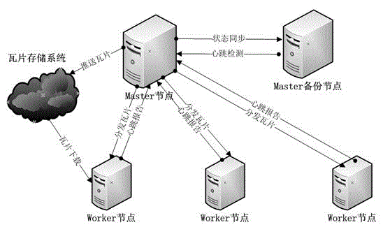
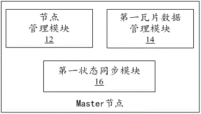
[0033] Such as figure 2 As shown, the GeoCDN system consists of one or more master nodes (also known as Master nodes or management node servers) and multiple sub-nodes (also known as Worker nodes or work node servers). Among them, the Master node is used to manage and schedule the Worker nodes, distribute tiles to the Worker nodes and receive the heartbeat reports of the Worker nodes, and push tiles to the tile storage system, etc. In order to ensure the data security of the Master node, a backup node of the Ma...
Embodiment 2
[0097] This embodiment provides a GIS service processing method, which is applied to the distributed GIS acceleration system in the first embodiment above, wherein, as Figure 5 As shown, the execution subject of the method is the Worker node of the distributed GIS acceleration system, which specifically includes the following steps S102 to S110.
[0098] Step S102: Receive the GIS request sent by the client.
[0099] When the user needs to request the GIS service of the cloud GIS center, the client sends a GIS request, and the Worker node located between the client and the cloud GIS center receives the GIS request.
[0100] Step S104: Parse the GIS request.
[0101]The Worker node resolves the service requested by the GIS according to the requested URL.
[0102] For example, whether the request is a request to obtain map tiles, 3D image tiles, 3D terrain tiles, or 3D model tiles, or whether the request is a SQL query request, or whether the request is Bounds query requests...
Embodiment 3
[0116] This embodiment provides a processing method for GIS services, which should be a further preferred embodiment on the basis of the above-mentioned embodiment two, such as Figure 5 As shown, this embodiment includes the following steps S202 to S218.
[0117] Step S202: Receive the GIS request sent by the client.
[0118] When the user needs to request the GIS service of the cloud GIS center, the client sends a GIS request, and the Worker node located between the client and the cloud GIS center receives the GIS request.
[0119] Step S204: Parse the GIS request.
[0120] The Worker node parses out whether the service requested by the GIS is a map service, data service, 3D service or analysis service according to the requested URL, and further, can analyze whether the type of the request is a map tile, vector tile or data of the map service Requests for attribute tiles, requests for model tiles, terrain tiles, image tiles, and vector tiles for 3D services, requests that ...
PUM
 Abstract
Description
Claims
Application Information
 - R&D
- Intellectual Property
- Life Sciences
- Materials
- Tech Scout
- Unparalleled Data Quality
- Higher Quality Content
- 60% Fewer Hallucinations
Browse by: Latest US Patents, China's latest patents, Technical Efficacy Thesaurus, Application Domain, Technology Topic, Popular Technical Reports.
© 2025 PatSnap. All rights reserved.Legal|Privacy policy|Modern Slavery Act Transparency Statement|Sitemap|About US| Contact US: help@patsnap.com


