On-orbit satellite image geometric positioning accuracy evaluation method on basis of multi-source remote sensing data

A technology of geometric positioning and satellite images, applied in image analysis, image enhancement, image data processing, etc., can solve problems such as increasing the difficulty of extracting control points, failing to meet requirements, and various distortions

Active Publication Date: 2015-04-29
NANJING UNIV OF SCI & TECH
View PDF2 Cites 50 Cited by
  • Summary
  • Abstract
  • Description
  • Claims
  • Application Information

AI Technical Summary

Problems solved by technology

There are large differences in the gray information of such reference images, and there are positioning accuracy errors and various distortions (generally rotation, stretching, translation, etc.) in the on-orbit images. These factors increase the difficulty of extracting control points, thus , the pixel-based method is no longer applicable, and the feature-based method cannot meet the demand

Method used


Image

  • On-orbit satellite image geometric positioning accuracy evaluation method on basis of multi-source remote sensing data
  • On-orbit satellite image geometric positioning accuracy evaluation method on basis of multi-source remote sensing data
  • On-orbit satellite image geometric positioning accuracy evaluation method on basis of multi-source remote sensing data

Examples


Embodiment Construction

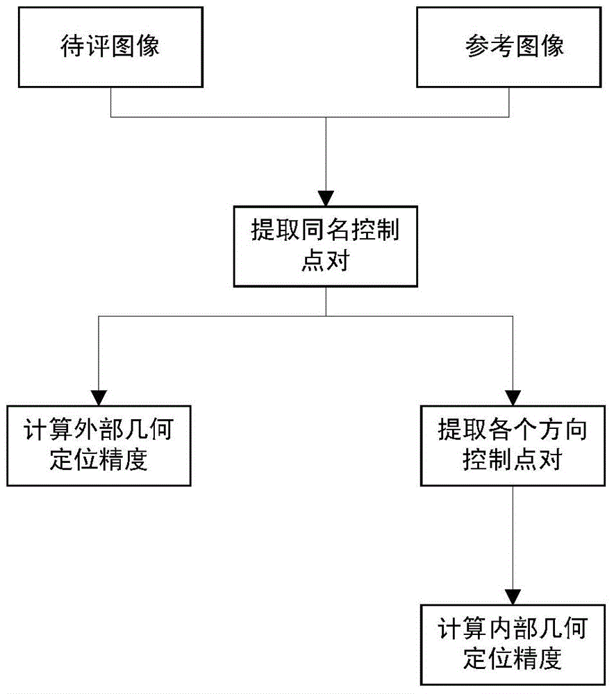
[0092] Concrete steps of the present invention are as follows:

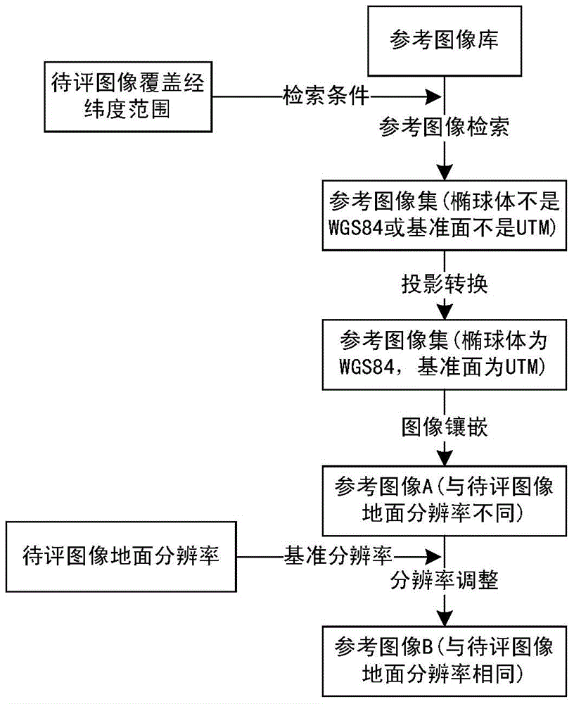
[0093] 1. Construct the reference image corresponding to the image to be evaluated.

[0094] First, the corresponding reference image set is searched according to the latitude and longitude range covered by the image to be evaluated. Since the image to be evaluated and the reference image set have different scales (with different resolutions, ellipsoids, and datums), a projective transformation of the image to be evaluated and the reference image set is required. Finally, the reference image set is stitched into a complete reference image.

[0095]

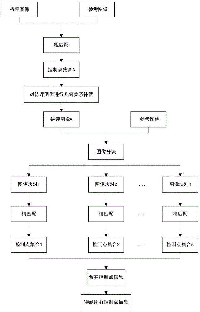
[0096] 2. Coarse matching

[0097] Due to the different imaging models and related parameters of multi-source remote sensing images, it is difficult to directly extract the same-named control point information between the image to be evaluated and the reference image. Therefore, the present invention adds rough matching to the image to be evaluated to perform geo...


PUM


Abstract

The invention discloses an on-orbit satellite image geometric positioning accuracy evaluation method on the basis of multi-source remote sensing data. The on-orbit satellite image geometric positioning accuracy evaluation method comprises the following steps: Step 1, regulating an image to be evaluated and a reference image into two images under the condition of the same spheroid, datum plane and resolution; Step 2, carrying out down-sampling on the two images and carrying out radiometric enhancement; Step 3, carrying out rough matching on the two images by using an Surf (Speed up robust features) algorithm and removing mismatched dot pairs by epipolar geometry; Step 4, according to a rough matching result, carrying out geometrical relationship compensation on the image to be evaluated and carrying out accurate blocking on the image to be evaluated, which is subjected to geometrical compensation, and the reference image; Step 5, aiming at block pairs of the image to be evaluated and the reference image, carrying out precise matching by using the Surf algorithm and removing mismatched dot pairs by epipolar geometry; Step 6, calculating external geospatial positioning accuracy and calculating internal geospatial positioning accuracy according to the screened direction control dot pairs. The on-orbit satellite image geometric positioning accuracy evaluation method can realize automatic, rapid and accurate evaluation on multisource high-accuracy remote sensing images from different sensors, different spectral regions and different time phases.

Description

technical field [0001] The invention relates to the field of remote sensing image evaluation, in particular to a method for evaluating geometric positioning accuracy of in-orbit satellite images based on multi-source remote sensing data. Background technique [0002] With the rapid development of domestic remote sensing satellites, the size of satellite images is getting larger and larger. When evaluating the geometric positioning accuracy of on-orbit images, it is necessary to stitch multiple reference images into one reference image. However, the reference image library is composed of remote sensing images taken from different time phases, different sensors and different satellites, which makes the spliced ​​reference images show the characteristics of multi-source. Therefore, extracting accurate and evenly distributed control point information between satellite images and reference images has become a technical difficulty in the evaluation of geometric positioning accura...

Claims


Application Information

Patent Timeline
Patent Type & Authority Applications(China)
IPC IPC(8): G06T7/00G06T5/50
CPCG06T7/344G06T7/75G06T2207/10032
Inventor 孙权森耿蕾蕾宋艳涛王思文陈艺虾
Owner NANJING UNIV OF SCI & TECH
Why Eureka
Try Eureka