Measurement and control communication method and system based on low-altitude unmanned aerial vehicle self-network

A technology of unmanned aerial vehicles and low-altitude aircraft, which is applied in the field of measurement and control communication, can solve the problems of unmanned aerial vehicle flight distance, single function, measurement and control communication system and method that cannot meet application requirements, and limited functions, so as to achieve communication efficiency and data throughput capacity, highly redundant backup performance, optimized communication and synergistic effects

Inactive Publication Date: 2015-04-29
NO 63655 TROOPS OF THE CHINESE PEOPLES LIBERATION ARMY
View PDF1 Cites 33 Cited by
  • Summary
  • Abstract
  • Description
  • Claims
  • Application Information

AI Technical Summary

Problems solved by technology

[0003] However, due to factors such as flight distance and single function, a single unmanned aerial vehicle plays a limited role in tasks such as reconnaissance and data relay under wide-area conditions.
Therefore, it is an important development direction in the field of unmanned aerial vehicles to form a cluster advan

Method used


Image

  • Measurement and control communication method and system based on low-altitude unmanned aerial vehicle self-network
  • Measurement and control communication method and system based on low-altitude unmanned aerial vehicle self-network

Examples


Embodiment 1

[0048] Embodiment 1: A certain long-distance communication relay task.

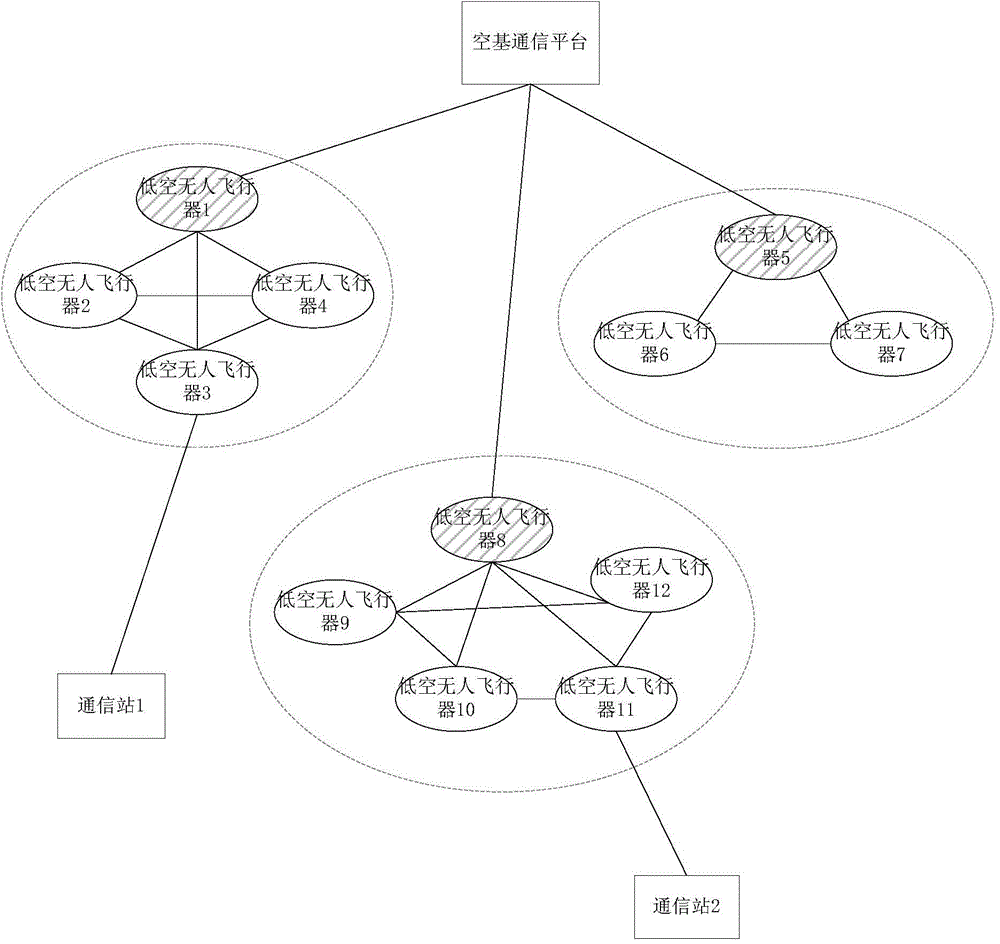
[0049] The business of a certain group needs to be completed by two node groups belonging to two different regions. The communication between the two regions requires a long-distance wireless data relay. The low-altitude UAVs are clustered and named C1~C3. Such as figure 1 As shown, in L1 administrative region, a data terminal sends a certain data sequence to communication station 1 through ground routing, and communication station 1 sends it to an aircraft node with communication relay function in cluster C1 through a wireless transmitting antenna, such as low-altitude unmanned Aircraft 3, the node transmits the communication relay demand to the cluster head of cluster C1, such as low-altitude unmanned aerial vehicle 1, after the cluster head calculates multiple alternative paths according to the best overall link performance priority routing algorithm, according to the transmitted data The type is opt...

Embodiment 2

[0051] Embodiment 2: A certain wide-area geological survey task.

[0052] For a large-scale geological survey task, the monitoring range of a single specific aircraft is small and the cost is high, and multiple low-altitude unmanned aerial vehicles are required to complete it together. Due to the continuous movement of low-altitude unmanned aerial vehicles, the number of aircraft above the target area is constantly changing. Need to adopt the method and system described in the present invention to accomplish. At a certain moment, it is assumed that the target area is covered by 3 sub-clusters, which are respectively named C1-C3, and the optical image data streams acquired by each sub-cluster are respectively P1-P3. After the cluster heads of clusters C1 and C2 calculate multiple alternative paths according to the best overall link performance routing algorithm, they optimize the routing sequence for data transfer according to the type of data transferred, and P1 and P2 are tra...


PUM


Abstract

The invention provides a measurement and control communication method and a measurement and control communication system based on a low-altitude unmanned aerial vehicle self-network, which are wide in acting coverage range and can realize cooperative matching and dynamic stabilization. The method comprises the steps of performing self-network clustering on low-altitude unmanned aerial vehicles at different heights in different regions; respectively linking the low-altitude aerial vehicles to an airborne communication platform and a ground communication terminal by taking a cluster as a unit; regularly updating and maintaining clusters in the low-altitude unmanned aerial vehicle self-network. The system comprises the airborne communication platform and a plurality of low-altitude unmanned aerial vehicles; the space-based communication platform is communicated with the low-altitude unmanned aerial vehicles, the ground communication terminal and other airborne communication platforms; the low-altitude unmanned aerial vehicles carry task loads and are used for being communicated with the airborne communication platform, the ground communication terminal and other low-altitude unmanned aerial vehicles. The airborne communication platform and all the self-networked low-altitude unmanned aerial vehicles are organized to form a two-layer composite three-dimensional information network. Therefore, the integral efficiency of the system is improved, and the stability is high.

Description

technical field [0001] The invention relates to the field of measurement and control communication, in particular to a measurement and control communication method and system based on an ad hoc network for low-altitude unmanned aerial vehicles. Background technique [0002] Low-altitude unmanned aerial vehicles refer to unmanned aerial vehicles that fly at and below the stratosphere, including multi-purpose drones and quadrotor aircraft. Low-altitude unmanned aerial vehicles have the advantages of simple control, strong maneuverability, clear images, and high cost-effectiveness. They are of great value for site surveys, emergency search, and communication support. [0003] However, due to factors such as flight distance and single function, a single unmanned aerial vehicle plays a limited role in tasks such as reconnaissance and data relay under wide-area conditions. Therefore, it is an important development direction in the field of unmanned aerial vehicles to form a clust...

Claims


Application Information

Patent Timeline
IPC IPC(8): H04W40/02H04W84/18
CPCH04W40/02H04W40/32H04W84/18
Inventor 唐佩佳谢永杰张文明徐欢施健康张颂张华良
Owner NO 63655 TROOPS OF THE CHINESE PEOPLES LIBERATION ARMY
Why Eureka
Try Eureka