Adaptive weight dark channel defogging algorithm for maritime aerial images of unmanned aerial vehicle

A self-adaptive, aerial image technology, applied in image enhancement, image data processing, computing and other directions, can solve the problems of affecting eyesight, navigation, the inability of imaging system to obtain clear images, different limitations, etc., to achieve remarkable effects and fog removal. better effect

Inactive Publication Date: 2015-05-06
OCEAN UNIV OF CHINA
View PDF5 Cites 4 Cited by
  • Summary
  • Abstract
  • Description
  • Claims
  • Application Information

AI Technical Summary

Problems solved by technology

[0004] However, in the practical application of image defogging algorithms, especially for the dehazing processing of unmanned aerial vehicle images at sea, these methods have shown different limitations sex
Because in the actual aerial photography of drones at sea, the impact of sea fog is particularly serious. Sea fog is a dangerous weather phenomenon, and its interaction with fog seriously affects the visual aid of navigation. The system was unable to obtain a clear image to provide data
In additio

Method used


Image

  • Adaptive weight dark channel defogging algorithm for maritime aerial images of unmanned aerial vehicle
  • Adaptive weight dark channel defogging algorithm for maritime aerial images of unmanned aerial vehicle
  • Adaptive weight dark channel defogging algorithm for maritime aerial images of unmanned aerial vehicle

Examples


Embodiment Construction

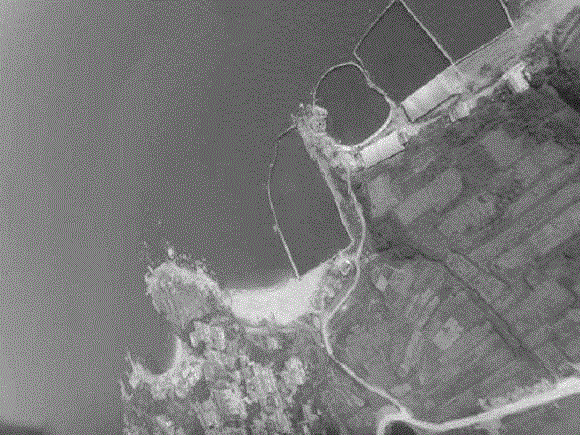
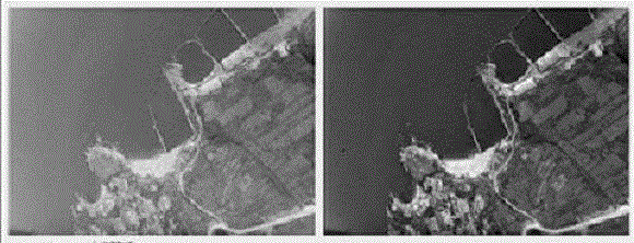
[0020] The self-adaptive weight dark primary color defogging algorithm based on unmanned aerial vehicle aerial photography image of the present invention comprises the following steps:

[0021] (1) First, extract the atmospheric illumination value and preliminary atmospheric transmittance value of the aerial image of the UAV.

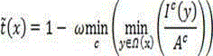
[0022] (2) According to the application of the adaptive weight algorithm, the color distance and spatial distance in the pixel information determine the size of the image block in the defogging, so as to obtain the corresponding transmittance value and correct the transmittance value of the UAV aerial image.

[0023] (3) According to the atmospheric illumination value obtained above and the transmittance value corrected by the adaptive weight algorithm, the aerial image of the UAV is dehazed.

[0024] (4) Comprehensively consider the various characteristics of UAV sea aerial images and perform dehazing processing on them, and compare the obtained fog-fr...


PUM


Abstract

The invention relates to the maritime aerial image defogging field and discloses an adaptive weight dark channel defogging algorithm for maritime aerial images of an unmanned aerial vehicle. The adaptive weight dark channel defogging algorithm for the maritime aerial images of the unmanned aerial vehicle fully considers the maritime aerial image defogging specificity, to be specific, the adaptive weight dark channel defogging algorithm for the maritime aerial images of the unmanned aerial vehicle does not only consider the effective defogging for a maritime specific object but also considers the fast, effective and correct defogging for a sea surface region in an image. The adaptive weight dark channel defogging algorithm combines foggy image quality degradation features with specific features of the sea area in the maritime aerial image, abandons a traditional defogging method, and fully considers the specificity of the sea area in the maritime foggy image. The adaptive weight dark channel defogging algorithm for the maritime aerial images of the unmanned aerial vehicle mainly includes that acquiring maritime aerial images of the unmanned aerial vehicle, performing dark channel defogging algorithm, performing adaptive weight algorithm, and defogging the maritime aerial images of the unmanned aerial vehicle. The adaptive weight dark channel defogging algorithm for the maritime aerial images of the unmanned aerial vehicle realizes the fast defogging for the maritime aerial images of the unmanned aerial vehicle and has broad prospect in the maritime or island aerial monitoring aspect.

Description

technical field [0001] The present invention relates to a defogging technology based on unmanned aerial vehicle aerial images in the field of image processing, in particular to an adaptive weight dark primary color defogging algorithm based on unmanned aerial aerial images. Background technique [0002] Due to the advantages of UAVs such as controllability, portability, low cost, low loss, reusability, low risk, and wide application fields, UAV applications have been widely developed in recent years. The integration of UAV and remote sensing technology makes UAV more automated and intelligent, and due to the characteristics of UAV, UAV aerial photography has the characteristics of high timeliness and high resolution, which further expands its application field. However, due to the local weather conditions and other reasons in the process of drone aerial photography, the aerial photography images of drones are often blurred, with mist and other phenomena, which degrades the q...

Claims


Application Information

Patent Timeline
IPC IPC(8): G06T5/00
Inventor 于方杰韩勇马纯永田丰林陈戈范龙庆孔庆红姜瑞
Owner OCEAN UNIV OF CHINA
Why Eureka
Try Eureka