Method for demarcating large-deformation landslide displacement field based on high-resolution remote sensing image

A technology of remote sensing images and calibration methods, applied in image analysis, image data processing, instruments, etc., can solve problems such as unsatisfactory matching results, errors in calculating landslide displacement, and low matching accuracy

Inactive Publication Date: 2015-06-10
NORTHEASTERN UNIV
View PDF3 Cites 31 Cited by
  • Summary
  • Abstract
  • Description
  • Claims
  • Application Information

AI Technical Summary

Problems solved by technology

Therefore, the algorithm is susceptible to noise interference, and the matching accuracy is low, and the matching results are not ideal, resulting in large errors in delineating the range of landslides and calculating the displacement of landslides under c

Method used


Image

  • Method for demarcating large-deformation landslide displacement field based on high-resolution remote sensing image
  • Method for demarcating large-deformation landslide displacement field based on high-resolution remote sensing image
  • Method for demarcating large-deformation landslide displacement field based on high-resolution remote sensing image

Examples


Embodiment

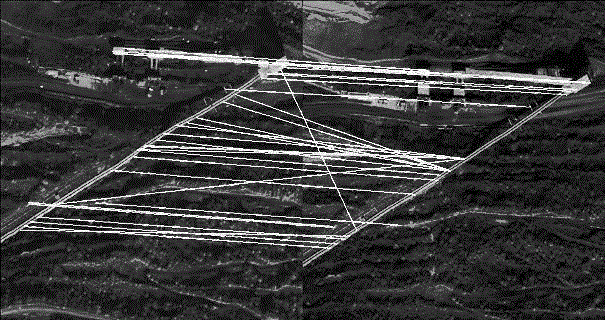
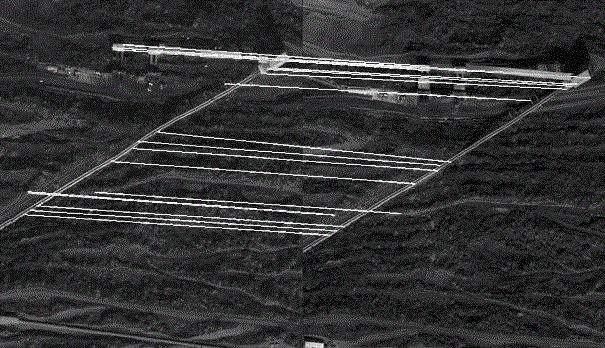
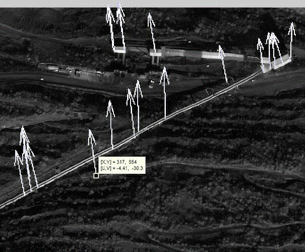
[0052] Taking a large landslide in China as an example, this research method is used to monitor the landslide body (including rock slope, soil slope, dangerous rock and rolling stone).

[0053] 1. Orthorectification of remote sensing images: first purchase two phases of high-resolution remote sensing images (with a spatial resolution of 0.5m), such as image 3 , Figure 4 . Since the shooting angles of the two remote sensing images are not orthographic, and the shooting angles are different, the two images are deformed to different degrees relative to the real ground conditions, and orthorectification is required. The method is to use the two-period DEM data ( Figure 5 , Figure 6 ) respectively correct the two images into orthophotos.

[0054] 2. Remote sensing image preprocessing: fusion and registration of two orthophoto images. Among them, the fusion is to make the image have the high-resolution advantages and multi-spectral advantages of the panchromatic image at the...


PUM


Abstract

The invention discloses a method for demarcating a large-deformation landslide displacement field based on a high-resolution remote sensing image. The method is that two geometric models are utilized to perform ortho-rectification for the high-resolution remote sensing image and corresponding DEM at different time phases in a search area; after the preprocessing and high-precision image matching, a vector set model is created based on the accurately matched feature points with the same feature points; the space displacement field of a landslide body can be demarcated according to the model. With the adoption method for early warning of large landslide disaster, in particular the landslide disaster under a complex terrain, the sliding landslide can be automatically found out and subjected to macroscopic monitoring, so that the macroscopic displacement direction and displacement of the large deformation landslide body at some time quantum can be obtained, and the sliding range can be determined; the basic data and basis can be provided to accurately monitor the landslide displacement and early warn the landslide disaster. The system and the method are mature in technology, low in cost, convenient to operate, quick to calculate, and high in accuracy; the scientific basis can be provided to monitor and evaluate the landslide disaster, and the safety in fire preventing and reduction can be ensured.

Description

technical field [0001] The invention relates to the technical field of target monitoring, and relates to a system and method for calibrating displacement fields of large deformation landslides based on high-resolution images. Background technique [0002] With the acceleration of economic and social development, the intensification of economic activities, the over-exploitation of natural resources, and the deterioration of the ecological environment, the natural disasters in our country are showing an increasingly serious development trend. Among many natural disasters, landslide disasters are one of the geological disasters with wide distribution, great impact and serious damage. The landslide movement is uncertain in time and space, and there is a huge energy conversion in the movement process, which brings great impact on human life, production and other fields. Inconvenience, or even major economic losses. [0003] Landslide disaster is the sliding phenomenon of slope r...

Claims


Application Information

Patent Timeline
IPC IPC(8): G06T7/00
Inventor 刘善军黄建伟王涵
Owner NORTHEASTERN UNIV
Why Eureka
Try Eureka