Method and system for planning paths in road networks

A technology of route planning and road network, applied in the field of geospatial information navigation, it can solve the problems of not considering the service of active points, unable to meet the service needs of users, etc., and achieve the effect of meeting the service needs.

Inactive Publication Date: 2015-09-30
SUZHOU UNIV
View PDF5 Cites 12 Cited by
  • Summary
  • Abstract
  • Description
  • Claims
  • Application Information

AI Technical Summary

Problems solved by technology

[0005] In view of this, this application provides a method and system for path planning in the road network to overcome the problem that the existing technology only considers distance or time, does not consider the service on the active point, and cannot meet the service needs of users. question

Method used


Image

  • Method and system for planning paths in road networks
  • Method and system for planning paths in road networks
  • Method and system for planning paths in road networks

Examples


Embodiment 1

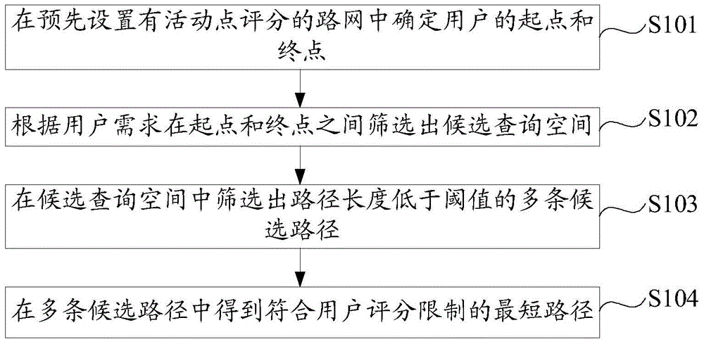
[0054] Embodiment 1 of the present application provides a method for path planning in a road network, such as figure 1 shown. The method includes:

[0055] S101: Determine the user's start point and end point in the road network with preset activity point scores.

[0056] There are many activity points on the road network, and these activity points are divided into many categories, such as gas stations, banks, restaurants, coffee shops, hospitals, etc. In this application, the activity points on the road network need to have ratings, and these ratings are obtained based on the feedback of users who have been to the activity points.

[0057] Specifically, the road network in this application can set its own rating system, that is, directly receive user ratings on activity points and store and display them; Scores and displays are stored in the road network system; or, both are used at the same time. Specifically, it can be set according to actual conditions, and is not limi...

Embodiment 2

[0091] On the basis of Embodiment 1, Embodiment 2 of the present application provides a system for path planning in a road network. like Figure 8 As shown, the system includes:

[0092] The determining module 501 is configured to determine the starting point and the ending point of the user in the road network preset with activity point scores.

[0093]Specifically, the road network in this application can set its own rating system, that is, directly receive user ratings on activity points and store and display them; Scores and displays are stored in the road network system; or, both are used at the same time. Specifically, it can be set according to actual conditions, and is not limited in this application.

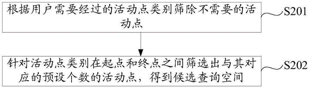
[0094] The first filtering module 502 is configured to filter out candidate query spaces between the starting point and the ending point according to user requirements.

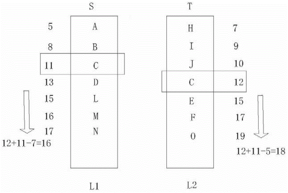
[0095] Specifically, such as Figure 9 as shown, Figure 9 It is a schematic structural diagr...


PUM


Abstract

The application provides a method and a system for planning paths in road networks. The method comprises the following steps: determining a starting point and an end point of a user in a road network with preset graded active points; screening out candidate query space between the starting point and the end point according to user needs; and screening out a path, the length of which is shorter than a threshold, from the candidate query space. With full consideration on service requirements of a user, the method and the system can be used for rapidly and conveniently providing a convenient and fast path meeting the service requirements of the user in a complicated road network environment.

Description

technical field [0001] The invention relates to the technical field of geospatial information navigation, in particular to a method and system for path planning in a road network. Background technique [0002] Path planning refers to planning a path that meets the user's needs according to the actual needs of the user, such as the path with the shortest distance or shortest time. [0003] Existing path planning methods mainly focus on path planning between identified multiple points. The most common path planning method is to plan a path between two known points, such as Dijskstra algorithm, Floyd algorithm, A* algorithm, etc. There are also some path planning methods between multiple points, such as the traveling salesman TSP problem, the travel planning query TPQ problem, and so on. [0004] However, the existing methods only consider the distance or time, without more consideration of the service on the active point, and there is no way to meet the user's service demand...

Claims


Application Information

Patent Timeline
Patent Type & Authority Applications(China)
IPC IPC(8): G01C21/34
CPCG01C21/34G01C21/3446
Inventor 刘冠峰戴军强许佳捷刘安李直旭赵雷周晓方
Owner SUZHOU UNIV
Why Eureka
Try Eureka